
Participatory zoning initiatives are underway in scores of protected areas in the tropics where forests are rich, but people are poor. Ideally, participatory zoning promises to
In this exercise, you will assume the role of a real-life stakeholder from Tambopata. Based on your stakeholder’s interests, you will define your land-use priorities for TNR, find allies, and negotiate with your opponents as you collectively negotiate and vote on one of four zoning proposal maps created in the local participatory planning process. In thinking about which map should guide land use activities in Tambopata’s future, consider the following: Why do your interests deserve priority? What kinds of activities will generate income without destroying biodiversity? Does your character have special interest in a certain area, e.g. the fertile, gold-rich and scenic riversides? Which areas have old-growth forests? Conversely, which areas are already deforested? Which activities are taking place up-stream from your character’s areas of interest?
You will advocate for your stakeholder’s vision for Tambopata by participating in a role-played roundtable and writing a position paper. At the roundtable and in the paper, you will identify the map you think best matches your character’s priorities, and (most importantly) defend your character’s position using moral, environmental and/or economic arguments:
Moral Arguments: Who should benefit from Tambopata’s forests and why? The area's original indigenous inhabitants? Or the largest group, namely small-scale farmers of mixed ancestry, some of whom have lived in Tambopata for decades, others only a few years? Which kinds of land use activities can offer security for Tambopata’s residents? Do Tambopata's forests and wildlife deserve protection apart from human economic concerns?
Environmental Arguments: What land uses are most likely to maintain biodiversity and/or other ecosystem services? How can environmentally destructive practices be mitigated? Why should certain activities be conducted in certain areas of TNR (e.g. where does old-growth forest persist? Where has forest already been cleared? Which areas are up/down stream? Which areas are closer to the Bahuaja-Sonene National Park?)?
Economic Arguments: Tambopata is poor. What kind of economic activities should have priority? Why? Which kinds of land use activities can generate capital and taxes to improve Tambopata’s services?
Instructors: If you are interested in using this assignment, contact naughton@geography.wisc.edu for a teacher’s guide.
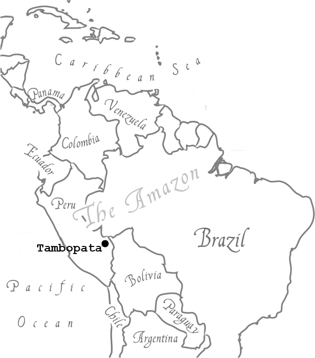
The Tambopata National Reserve (TNR) was created in 1990 to protect one of the most biologically diverse and least disturbed forests on the planet. The region is also home to indigenous people, like the Ese’eja, who see their very survival threatened by development. Many other local residents see Tambopata as a poor region of Peru that contains untapped reserves of timber, gold, and farmland.
To balance biodiversity protection with economic development, officials are promoting participatory zoning of the 272,000 hectares of land within TNR.
Leading this zoning exercise is Peru’s Ministry of the Environment. The Ministry has invited local stakeholder groups to propose zoning maps and promote their map at a public roundtable.
The consensus map selected at the roundtable will guide future management.
Madre de Dios: (Literally “Mother of God”) the name of the 8.5 million ha Department (region) surrounding Tambopata. It is the least populated area in Peru (~ 1 person/km2).
Hectare: A 100 x 100 m unit of land (1 hectare = 2.3 acres). Abbreviated “ha". Most Tambopata farms are ~40 ha.
Puerto Maldonado: The largest city (~90,000) in Madre de Dios. It has doubled in size in the last 10 yrs.
SERNANP: The National Service for Natural Protected Areas is the govt. agency in charge of parks, reserves, wildlife and forests. It is part of Peru’s Ministry of Environment.
Castañeros: People who harvest castañas (Brazil nuts). Madre de Dios holds nearly 30% of the world’s supply.
Ese’eja: The largest group of indigenous people in the region, numbering ~600 today, some estimate ~10,000 before 1890.
Artisanal mining: Small-scale mining performed by individuals, often on an informal/unofficial basis. Technology used has lower impact than industrial mining.
Industrial mining: Large scale, high-capital mining activities typically require a formal concession.
Reduced-impact logging: A logging practice designed to cause the least ecological impact on forests possible. Ideally informed by studies of local ecosystem dynamics.
Concession: A formal permit issued by the government for a certain activity (e.g. mining, logging, ecotourism) for a specified period of time (usually several years, although not permanent).
REDD+: "Reduced Emissions from Deforestation and Forest Degradation", is an incentive-based mechanism for reducing greenhouse gas emissions through improved forest management in developing countries.
Bosques Amazónicos (BAM): A for-profit organization facilitating a REDD project in Tambopata.
Nature-based tourism: Any form of tourism based on natural attractions.
Ecotourism: A form of nature-based tourism in which tourist impacts on the environment are mitigated.
1890-1915: The global demand for rubber leads companies to penetrate the forests of Tambopata to tap rubber trees. These companies bring the first wave of colonists, diseases, and market economies to the region.
1930: People begin to extract Brazil nuts from Tambopata for international markets. Small-scale gold mining begins.
1990s: The Tambopata Candamo Reserve Zone (TCRZ) is created as a temporary reserve on 1.5 million hectares, including uninhabited forests and areas settled by ~6000 people. The local farmers’ federation FADEMAD and a local conservation group, Conservation Internacional-Peru (CI-Peru), work together to classify land in the region according to its agricultural potential and create a national park (“Bahuaja-Sonene”) (see VIDEO “Return to Tambopata”).
Late 1990s, early 2000’s: Participatory mapping and zoning exercises resume.
2000: The Peruvian Congress passes a new Sustainable Forestry Law. A moratorium is temporarily placed on logging in the Peruvian Amazon due to “destructive, corrupt, and wasteful” practices. Local loggers revolt and burn government vehicles and confiscated timber. They demand to log forests and to dissolve the TCRZ. The protestors set up a roadblock near the airport. One person killed, offices burned. After three days, anti-riot police from Lima squelch the protest with tear gas and arrests. INRENA lifts the logging moratorium.
2008: As global economic crisis sets in, gold prices soar, and a gold rush brings tens of thousands of Peruvians to Tambopata.
2012: SERNANP uses an emergency decree to halt mining within the Tambopata Reserve. Public riots break out. The National Federation of Miners of Peru strikes and burns government buildings. Six people die in the ensuing conflict. The decree stands. Peru’s military evicts most of the miners from the Reserve. Mining continues (illegally) in the proposed Buffer Zone.
2020: Mining conflicts continue to this day…

Jose Herrera and his family moved five years ago to the Tambopata National Reserve in search of new farm land and opportunities. They left Cuzco, a city in the Peruvian Andes, due to land scarcity and unemployment. Immigrants to the Amazon, like Jose and his family, are often referred to as ‘colonists’. Like other colonists, upon his arrival, Jose claimed 30 hectares A 100 x 100 m unit of land (1 hectare = 2.3 acres). Abbreviated “ha". Most Tambopata farms are ~40 ha. of land along the highway. Every year, Jose and his family plant rice and corn in fields cleared in the forest until the soil becomes ‘tired’ and less productive. Then, they convert the old field to cattle pasture and clear a new field in the forest. They eat most of the food they grow and sell the surplus if they have any.
Like other poor residents of Tambopata, Jose is worried about his family’s financial future. He hopes someday to buy a truck and sell food in town or
to local miners. Or, he might convert his whole farm into a pasture and get a job in the city. Some of his neighbors are talking about selling their land
to oil
palm companies,
Development Officer for Palmas del Peru
Mariella works for a leading company in Peru’s growing oil palm industry. Her job is to find new regions in Peru to
promote oil palm production which pays big profits to producers. Click
Palm Company to learn how Mariella would like to work
with smallholders to bring economic gains to the area.
and then moving deeper into the forest to claim new farmland. But Jose does not have legal title to his land and doesn’t think he’d
be paid much for it. He is a member of the Agrarian Federation
(FADEMAD),
Leader of the Agrarian Federation (FADEMAD)
Alan leads FADEMAD, a grassroots political organization that represents
~5000 small farmers in the Madre de Dios region. Alan believes that poor farmers’ quality of life
depends on a healthy environment. Thus, he tries to defend local farmers AND the forest. Click
FADEMAD to learn how
Alan weighs the costs and benefits of land management practices of his varied constituents are interested in pursuing.
a local political organization, and has heard some members talk about transitioning from shifting agriculture to agroforestry. He might even be able to start
growing organic cacao (the source of chocolate) and sell it via a local marketing coop that could negotiate a better price. Consumer demand for certified chocolate
is on the rise. But Jose has no knowledge or experience with tropical tree crops like cacao – he would need training to pursue agroforestry. He also wonders how he
could survive financially while waiting the five years for the cacao trees to bear fruit. He could always turn to working for his friends in their illegal gold mining
camp. Gold mining is back-breaking, often dangerous work, but if you’re lucky, you can make a lot of money in a short time.