 |
 |
 |
 |
 |
 |
![]()
---- Utilize components of the “SoLIM” approach to help assist
in the development and evaluation of a computer generated-landscape model
that captures existing soils and environmental knowledge, creates data
layers for input into a GIS, and produces raster and vector maps suitable
for used in soil survey, as well as providing the potential for the use
of “fuzzy soil logic” in the development of “soilscape-based”
soil interpretations.
---- Evaluate these procedures and products as to their applications with
the National Cooperative Soil Survey, as well as within the National Park
Service and the Natural Resources Conservation Service. In particular,
assess the adoption of these techniques for mapping soil resources over
areas that are not easily accessible for field observation.
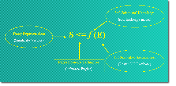
SoLIM
stands for “Soil Land Inference Model”. It is a fuzzy inference
scheme for estimating and representing the spatial distribution of soil
types in a landscape. There are four key components included in this framework:
(1) Soil-Landscape model: The knowledge on the relationships between the
soil series and their surrounding environmental variables can be obtained
from soil experts using a set of knowledge acquisition techniques.
(2) GIS Database: The soil formation environmental database of an area
can be characterized and represented using GIS and RS techniques.
(3) Inference Engine: A set of computer programs under fuzzy logic used
to estimate and predict the spatial distribution of soil types in a landscape
based on Soil-Landscape model and GIS database.
(4) Fuzzy Representation: A Similarity Vector Model to represent soil
as continuum.
![]()
![]()
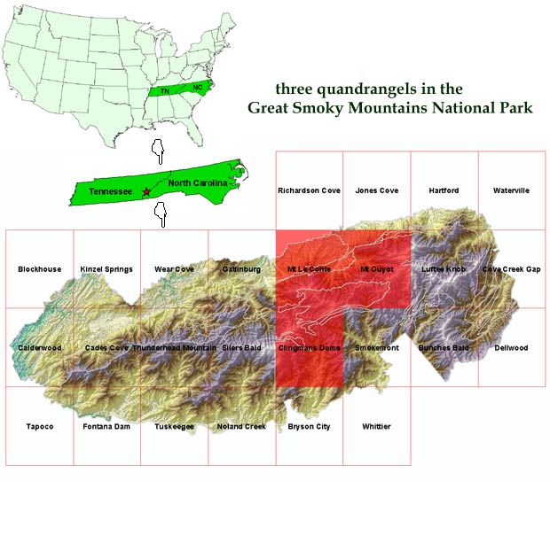
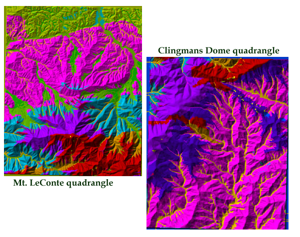
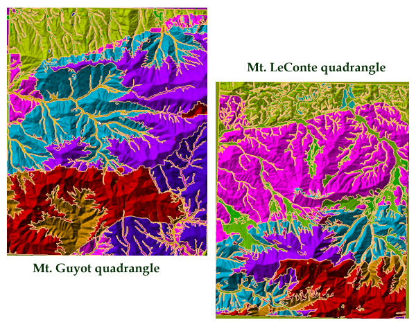
Our study area is three quadrangles in the Great Smoky Mountains National Park, which straddles the boundary between North Carolina State and Tennessee State. In phase I, we worked on Mt. Guyot quadrangle and in phase II, we worked on Mt. LeConte quadrangle and Clingmans Dome quadrangle.
![]()
![]()
Results:
Three soil information products were provided: fuzzy membership maps of
individual soil types (series), raster soil series maps, and conventional
soil polygon maps.
---- Fuzzy Membership Maps
Fuzzy membership maps showing the spatial gradation of soils and preserving
the intermediate nature (between types nature) of soils. This preservation
would assist in soil interpretation. The images show the membership variation
of Anakeesta (Right Upper) and Sylco (Right Lower) respectively. Anakeesta
occupies most ridge top areas and slopes areas above frigid line while
Sylco occupies most ridge top areas and slopes areas below frigid line.
The membership maps show a realistic gradation of the two soil types when
one travels from high elevation to low elevation position.
----
Raster Soil Maps
Conventional soil type maps can be produced through harden process from
the fuzzy membership maps derived from the SoLIM approach.
----
Polygon Soil Maps (with the minimum mapping size of 1 hectare)
Conventional soil polygon like maps can also be created from the fuzzy
representation. We know that it is inevitable for a soil polygon to include
some small soil bodies which are different from what the soil polygon
is labeled to be. These inclusions can be reported per soil polygon basis
which is a great improvement over the conventional approach to reporting
inclusions (often lumped into a mapping unit).
Evaluation:
---- Accuracy for model develop area – Mt. Guyot: 30 meter resolution
- 96.43% (54 out of 56); 10 meter resolution – 98.21% (55 out of
56)
---- Accuracy for extrapolated areas – Mt. Le Conte: 30 meter resolution
- 92.68% (38 out of 41); 10 meter resolution– 92.68% (38 out of
41)
---- Accuracy for extrapolated areas – Clingmans Dome: 30 meter
resolution - 97.67% (42 out of 43)
![]()
University
of Wisconsin - Madison
A-Xing Zhu and James
Burt, principal investigators, provide leadership in applying
and evaluating the SoLIM approach in the study area;
Rongxun Wang, project assistant,
do soil inference
Natural Resources Conservation Service
Darwin Newton and Roy
Vick, provide administrative leadership respectively for
the states of Tenne4ssee and North Carolina;
Anthony Khiel and Doug
Thomas, serve as the local NRCS project coordinator;
Berman Hudson and Sheryl
Kunickis, provide guidance and support from
the national NCSS perspective and oversee partial funding of the proejct
from the NRCS persepetive
National Park Service
Pete Biggam, serve as project
coordinator from the NPS;
Mike Jenkins, serve as the
local contact representing GRSM
![]()
![]()