We love cartography because it draws from art, science, and technology. In the Cart Lab, we
conduct
mixed-methods research on the design and use of maps and visualizations. Our research crosses
theoretical, methodological, organizational, and technological dimensions of the discipline, and
contributes to the sibling disciplines of geography, GIScience, human-computer interaction,
information visualization, and visual analytics.
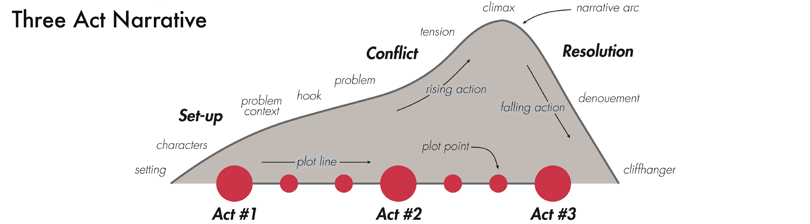
Visual Storytelling
Projects in Visual Storytelling
-
Song Z, RE Roth, L Houtman, T Prestby, A Iverson, and S Gao. (accepted).
Visual storytelling with maps: An empirical study on story map themes and narrative
elements, visual
storytelling genres and tropes, and individual audience differences.
Cartographic Perspectives.
-
Baldrica-Franklin G. 2021.
Mapping narrative content and structure in online atlases Abstracts of the ICA.
3: 22. [abstract]
-
Roth RE. 2021.
Cartographic design as visual storytelling: Synthesis and review of map-based
narratives, genres, and tropes.
The Cartographic Journal.
58(1): 83-114. [pre-print]
-
Moore SA, RE Roth, H Rosenfeld, E Nost, K Vincent, MR Arefin, and TM Buckingham. 2019.
Undisciplining environmental justice research with visual storytelling.
Geoforum.
102: 267-277. [pre-print]
-
Song Z. 2017. Map-based visual storytelling: An assessment of emerging
genres and tropes. MS Thesis in Cartography and GIS. University of Wisconsin–Madison:
Madison, WI.
Web & Mobile Map Design
Interactive maps increasingly are used online or through mobile devices. Accordingly, much of
the
canon of cartographic design principles needs to be revised or completely rethought due to the
contemporary design and use context. Our production, research, and education intersects at how
we
think about a web-enabled and mobile platform, pushing the boundaries of the underlying software
and
hardware technologies while considering new users and use contexts.
Projects in Web & Mobile Map Design
-
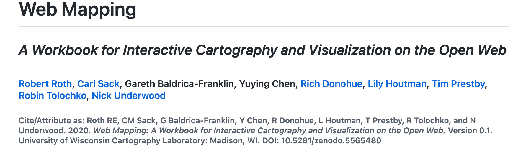
RE Roth, CM Sack, G Baldrica-Franklin, Y Chen, R Donohue, L Houtman, T Prestby, R
Tolochko, and N Underwood. 2021.
Introducing Web Mapping: A workbook for interactive cartography and visualization on the
open web. Abstracts of the ICA. 3: 254. [abstract]
-
Abraham L. 2019. Where do we go from here?: Understanding mobile map design. MS Thesis
in Cartography and GIS. University
of Wisconsin–Madison: Madison, WI.
-
Roth RE, S Young, C Nestel, C Sack, B Davidson, J Janicki, V Knoppke-Wetzel, F Ma, R
Mead, C Rose, and G Zhang. 2018.
Global landscapes: Teaching globalization through responsive mobile map design. The
Professional Geographer.
70(3): 395-411. [pre-print]
-
Roth RE, D Hart, R Mead, and C Quinn. 2017.
Wireframing for interactive & web-based geographic visualization: Designing the NOAA
Lake Level Viewer. Cartography and Geographic Information Science.
44(4): 1-20. [pre-print]
-
Sack CM, RG Donohue, and RE Roth. 2014. Interactive and
multivariate choropleth maps with D3. Cartographic Perspectives.
78: 57-76. [open access]
-
Roth RE, RG Donohue, CM Sack, T Wallace, and T Buckingham. 2014. Keeping
pace with evolving open source web mapping technologies Cartographic
Perspectives.
78: 25-52. [open access]
-
Davidson B. 2014. Cartographic design for mobile devices: A case study
using the UW-Madison interactive campus map. MS Thesis in Cartography and GIS.
University
of Wisconsin–Madison: Madison, WI.
-
Roth RE. 2013. Interactive maps: What we know and what we need to know.
Journal of Spatial Information Science. 6: 59-115. [pre-print]
Critical and Community Mapping
Projects in Critical and Community Mapping
-
Bley K, K Caldwell, M Kelly, J Loyd, RE Roth, TM Andersen, A Bonds, J Plevin, D Madison,
C Spencer, and T Sims. 2021.
A design challenge for transforming justice.
GeoHumanities.
1-22. [pre-print]
-
Kelly M. 2021.
Mapping bodies, designing feminist icons.
GeoHumanities.
7(2): 529-557. [pre-print]
-
Roth RE, C Nestel, TB Andersen, J App, M Cloutier, C Guo, A Iverson, M Kohls, J
Lodermeier, A McKindsey, and E Milligan. 2020.
Madison and vicinity: A tangible map quilt.
Cartographic Perspectives.
95: 50-56. [open-source]
-
Iverson A. 2019. Sketch mapping workshops for early teens as a case study in
post-representational cartography. MS Thesis in Cartography and GIS. University of
Wisconsin–Madison: Madison, WI.
-
Kelly M. 2019.
Mapping Syrian refugee border crossings: A feminist approach.
Cartographic Perspectives.
93: 34-64. [open-source]
Usability Engineering & User-centered Design
We couple our interests in interactive, online, and mobile mapping with a methodological
contribution on the process of map design. Design is a process, and the digital
revolution
has introduced new design considerations and metrics of success. We draw from usability
engineering
and user-centered design to streamline workflows for taking a design from concept to deployment.
Further, we adapt methods pioneered in social science for the discount evaluation of maps,
enabling
rapid user feedback throughout the design process.
Projects in Usability Engineering & User-centered Design
-
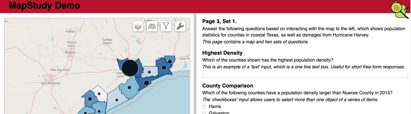
Vincent K, RE Roth, SA Moore, Q Huang, N Lally, CM Sack, E Nost, and H Rosenfeld. 2019.
Improving spatial decision making using interactive maps: An empirical study on
interface complexity and
decision complexity in the North American hazardous waste trade. Environment and
Planning B: Urban Analytics and City Science.
46(9): 1706-1723. [pre-print]
-
Roth RE, A Çöltekin, L Delazari, HF Filho, A Griffin, A Hall, J Korpi, L Lokka, A
Mendonça, K Ooms, CP van Elzakker. 2017.
User studies in cartography: opportunities for empirical research on interactive maps
and visualizations.
International Journal of Cartography.
3(1): 61-89. [pre-print]
-
Rose C. 2015. Mapping technology in wilderness search and rescue. MS Thesis in
Cartography and GIS. University of
Wisconsin–Madison: Madison, WI.
-
Roth RE, KS Ross, and AM MacEachren. 2015. User-centered design for
interactive maps: A case study in crime analysis. International Journal of
Geo-Information. 4(1): 262-301. [open access]
-
Mead R. 2014. Expert perspectives on the design and use of learning
materials for neocartographic interfaces. MS Thesis in Cartography and GIS. University
of
Wisconsin–Madison: Madison, WI.
-
Sack C. 2013. Mapmaking for change: Online participatory mapping tools for
revealing landscape values in the Bad River Watershed. MS Thesis in Cartography and GIS.
University of Wisconsin–Madison: Madison, WI.
-
Roth RE and M Harrower. 2008. Addressing map interface usability: Learning
from the Lakeshore Nature Preserve interactive map. Cartographic Perspectives.
60:
46-66. [open access]
User Experience & User Interface (UX/UI) Design
Increasingly, cartographers need both to encode geographic information as well as
code
a useful and usable interface for exploring the resulting maps. But interface design is much
more
than pushing 0s and 1s, and few time-tested principles exist to inform design of the user
experience. Increasingly, we contribute to interaction science, approaching topics such as
cartographic interaction primitives (i.e., the building blocks of an interactive map), interface
flexibility versus constraint, user expertise and motivation, coordinated multiview
geovisualization, and applications of interactive mapping to support geography.
Projects in User Experience & User Interface (UX/UI) Design
-
Vincent K. 2017. The role of cartographic interface complexity on spatial
decision making: A case study in the North American hazardous waste trade. MS Thesis in
Cartography and GIS. University of Wisconsin–Madison: Madison, WI.
-
Tolochko R. 2016. Contemporary professional practices in interactive web
map design. MS Thesis in Cartography and GIS. University of Wisconsin–Madison: Madison,
WI.
-
Roth RE. 2012. Cartographic interaction primitives: Framework and synthesis.
The Cartographic Journal. 49(4):376-395. [pre-print]
Pedagogical Research
Projects in Pedagogical Research
-
Houtman L and RE Roth. 2021. Introducing a QGIS
technical supplement for Mapping for a Sustainable World. Abstracts of the ICA.
3: 113. [abstract]
-
Sack C. 2018. Curriculum development and pedagogy for teaching web mapping.
PhD Dissertation in Philosophy (Geography). University of Wisconsin–Madison: Madison,
WI.
-
Roth RE and AM MacEachren. 2016. Geovisual analytics and the science of
interaction: An empirical interaction study. Cartography and Geographic Information
Science. 43(1): 30-54. [pre-print]
-
Donohue R. 2014. Web cartography with web standards: Teaching, learning, and
using open source web mapping technologies. PhD Dissertation in Philosophy (Geography).
University of Wisconsin–Madison: Madison, WI.
Cartographic Design
Much of the empirical research in cartography over the past half century addressed
representation
design, evaluating how maps visually encode geographic information from perceptual, cognitive,
and
social/critical perspectives. We remain active in the study of cartographic design, particularly
in
the face of evolving mapping technologies and professional practices. Our recent research on
cartographic representation includes aesthetics and style, bivariate and multivariate mapping,
multiscale generalization, semiotics, terrain representation, and uncertainty visualization,
among
other topics.
Projects in Cartographic Design
-
Thorn R. 2018. How to play with maps. MS
Thesis in Cartography and GIS. University of Wisconsin–Madison: Madison, WI.
-
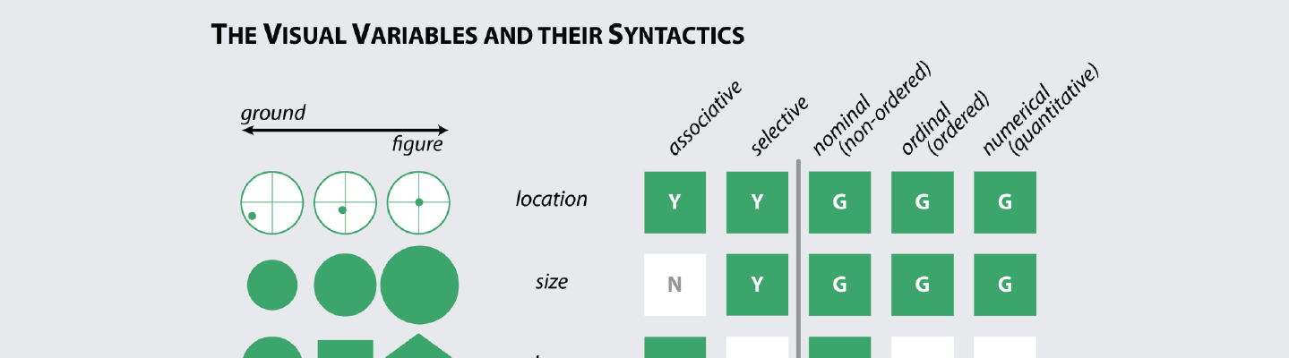
Roth RE. 2017. Visual variables. In: International
Encyclopedia of Geography: People, The Earth, Environment and Technology: 1-11.
[pre-print]
-
Nestel C. 2016. Designing an experience: Maps and signs at the archaeological site of
Troy. MS
Thesis in Cartography and GIS. University of Wisconsin–Madison: Madison, WI.
-
Knoppke-Wetzel V. 2014. How technological changes aesthetically defined
pre-1900s maps: A stylistic look at woodblock, copperplate, & lithograph print maps. MS
Thesis in Cartography and GIS. University of Wisconsin–Madison: Madison, WI.
-
Elmer M. 2012. Symbol considerations for bivariate thematic mapping. MS
Thesis in Cartography and GIS. University of Wisconsin–Madison: Madison, WI.
-
Roth RE, CA Brewer, and MZ Stryker. 2011. A typology of operators for
maintaining legible map designs at multiple scales Cartographic Perspectives.
60:
29-64. [open-access]
-
Roth RE, AW Woodruff, and ZF Johnson. 2010. Value-by-alpha maps: An
alternative technique to the cartogram. The Cartographic Journal. 47(2):
130-140. [pre-print]