
It’s been an eventful summer in the UW–Madison Cartography Lab! On top of our usual summer contract work, a Cart Lab alumnus put us in contact with Rolling Stone Magazine for a map project. Rolling Stone requested a reference and locator map to supplement an article investigating the genocide of Rohingya Muslims in Myanmar. The article documents the survival stories of two individuals and their intense journeys to relative safety in Bangladesh. With a quick turnaround of a week, Meghan Kelly—Geography PhD student and the Cart Lab Project Assistant—took on the project with the help of the Cart Lab collective.
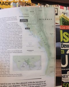
Meghan was initially provided the manuscript, map dimensions, and examples of design and aesthetics that Rolling Stone was seeking. After reading the manuscript and researching more on the topic and region, Meghan developed a list of place names and key points of interest discussed in the article and collected corresponding geospatial data from Natural Earth and UNHCR. Rolling Stone’s graphic’s editor requested soft terrain and land cover information to add texture to the base map. Meghan worked with Daniel Huffman—the Cart Lab’s cartographer in residence—to find a suitable elevation data (DEM) from Viewfinder Panorama and resources from Geography 572 (Graphic Design in Cartography) to find classed land cover data. These vector and raster datasets were processed and collated in ArcMap, a geospatial analysis and processing program. The vector datasets were exported to Adobe Illustrator—vector graphic design software—for design. Meghan exported the DEM raster file to Blender—3D modeling and animation software—to create the shaded relief or terrain texture where she followed one of Daniel’s incredibly generous online tutorials. The hillshade and land cover data were combined in Photoshop for base map design. The raster data was finally merged with the vector files in Adobe Illustrator. Meghan brought early drafts of the map to Cart Lab during lunch time for map critiques where she tested new ideas and edited the map in real time.
Drafts and edits were then sent back and forth with Rolling Stone and in the frantic final hours, Meghan, Daniel, and Tanya Buckingham finalized the map for print publication. It was truly an exciting, exhausting, and collective effort!
The map was published in print in the August 2018 issue of Rolling Stone and is now available online as well. Stay tuned for the September 2018 print issue! Meghan and Emily Pettit have another map in Rolling Stone coming out soon.


