By: Michael Hasinoff and Howard Veregin of the Wisconsin State Cartographer’s Office
A “cartographic phantom” is a community that appears on a map but does not actually exist on the ground. Phantoms often occur when small rural communities disappear, but the map is not updated. The Geographical Names Information System (GNIS) – the official federal repository for geographic nomenclature maintained by the US Geological Survey (USGS) – contains a significant number of phantoms; these communities have remained in GNIS due to the comprehensive nature of the repository and the desire to not reclassify communities without strong evidence of their disappearance.
It is important to update GNIS because it is the source for the names of unincorporated places (or as we’ve named them, “unincs”) for the USGS’s digital topographic maps, called “US Topos.” Likewise, websites such as Google Maps use GNIS as a source of unincorporated place name data, as do other online and traditional map publishers. Consequently, upon close inspection of many maps, labels for non-existent unincs are common.
The Wisconsin State Cartographer’s Office (SCO) has been working to map unincs in Wisconsin for several years. Unincorporated places are recognized, named communities that are not officially incorporated. These places often become phantoms because they are small communities, often exist in areas of declining population, and are not actively monitored by state or federal agencies like the Census Bureau.
Recently, the SCO assembled nearly 600 potential cartographic phantoms in Wisconsin that are currently recorded in GNIS. Our goal is to assist the USGS update GNIS by identifying which of these places should be reclassified. We do not want the places removed from GNIS, but rather reclassified as “historical.” This will ensure that the places continue to be accessible for mapping purposes but will allow for more refined cartographic treatment both on US Topos and other types of maps.
The first phase of the SCO project implemented a simple mapping methodology to identify places that are unambiguously cartographic phantoms, in that they have no residential population of any size within a reasonable distance of the GNIS-defined location. This so-called “Fast Phantom Finder” method involves the following:
- The creation of a ¼-mile buffer around the GNIS-defined location. This is the same distance used by the Wisconsin Department of Transportation as part of the general criteria and guidelines used to recognize and provide signage for an unincorporated community.
- The selection of parcels from the Wisconsin Statewide Parcel Map that were: a) in whole or in part, classified as residential (e.g., only residential (Class 1), residential/commercial mix (Class 1, 2), residential/agricultural mix (Class 1, 3), etc.); and b) had an assessed value of improvements over $800. This value is used to filter out residential parcels without improvements, and therefore have no residents. We use a value of $800 rather than $0 to eliminate parcels that contain only non-inhabitable improvements such as a shed or garage. The resulting selected parcels we call “residential parcels.”
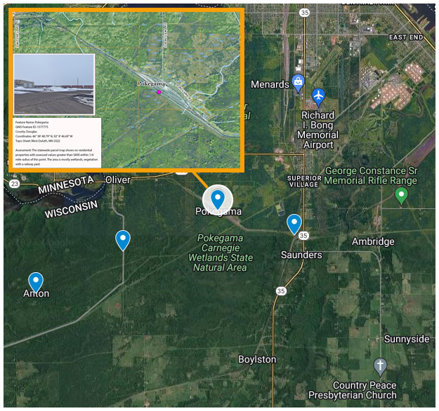
- A spatial join of the residential parcels and the buffer to compute the number of such parcels within the buffer. The assumption is that areas with no residential parcels have no residential population and hence, no existing community. Therefore, those records with a count of zero are considered potential phantoms. We identified 58 potential phantoms from this procedure.
- Additional evidence, including visual inspection of imagery, consideration of anomalies (such as missing parcel data) and in some cases, on-the-ground verification. This process pared the list down to 31 likely phantoms.
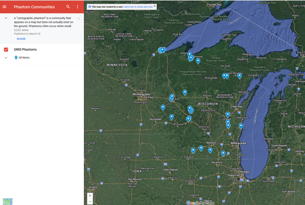
These 31 likely phantoms can be seen on this simple Google Map (laptops or larger are more user friendly than phones). Clicking on a phantom reveals details of the feature as well as a URL which links to an image of how the feature appears on the most recent US Topo map. Our analysis and an on-the-ground photo, where available, are included in the image. After reaching out to the Wisconsin geospatial community for comments, they were submitted to the GNIS and are currently being updated in the GNIS repository.
So, while the Fast Phantom Finder helped us find some unincorporated places that were unequivocally phantoms, we changed tack slightly by trying to elucidate what other criteria, or combination thereof, best define a true unincorporated place. Conversely, we hoped to see if an absence of these criteria helps to identify phantoms. We thus created the “Trewarthian Uninc Finder,” named in homage to one of the pioneers of population geography and UW-Madison’s own, Glenn Trewartha (yes, of the Trewartha Room on the 3rd floor of Science Hall!). To help us define the criteria for our new Finder, we referred to one of Trewartha’s journal articles in which he maintained that to quantitatively define a place as unincorporated (or as he referred to it, a hamlet) there “must be a minimum of, (1) four active residence units, at least two of which are non-farm houses; (2) a total of at least six active functional units, – residential, business, social or otherwise; and (3) a total of at least five buildings actively used by human beings.” To apply these criteria, our method included the same first step as the Fast Phantom Finder above. The second step varied in that, within the buffer, we counted the respective numbers of uniquely classified parcels and determined if they met Trewartha’s criteria. To do this, we counted:
- The number of occurrences of parcels that include, but are not limited to, a residential, Class 1, classification. (i.e., a single parcel could be only Class 1, or could be a mix of classifications, for example, Class 1, 2). To meet Trewartha’s criteria, this number needs to be at least 4.
- The number of occurrences of parcels that are only residential. (i.e., a single parcel is a Class 1 and not a mix of classifications). This number needs to be at least 2.
- The total number of functional units within all parcels that include residential and/or commercial (Class 2) and/or manufacturing (Class 3). This number is the equivalent of Trewartha’s “functional units” and must be at least 6. For example, a Class 1 parcel would be 1 functional unit, while a Class 1,2 parcel would be 2 functional units. Put another way, a parcel may have both a business and a residential classification, thereby counting as 2 functional units.
- The total number of occurrences of parcels that are Class 1 or 2 or 3 or combination thereof. This represents the number of Trewartha’s “active buildings” and must be at least 5. This differs from functional units as each of the following classifications are counted as one active building: (1), (2), (3), (1,2), (1,3), (2,3), (1,2,3).
Without any statistical analysis, our results appear to be mixed. On the one hand, it appears that Trewartha knew his stuff about unincs and how to quantitatively define them. Of 879 previously ground-truthed (“verified” or “true”) unincs, 92% of them met all four of his criteria and 3% met none. For a second group of 116 unincs, we had some kind of reservation defining them as true unincs despite having had on-the-ground visits. We called these “others” and encouragingly, 86% of them met all four of Trewartha’s criteria while 4% met none.
On the other hand, it appears that finding Phantoms will remain elusive: the Trewartha Uninc Finder did not have as much success at identifying Phantoms as we hoped it would. We had a list of 582 unincs compiled from the GNIS that had not yet been investigated. Given our background knowledge of Wisconsin geography and other unincs, it was our initial hunch that the vast majority of these would be Phantoms (we, thus, gave this list the inspiring name of, “Phantoms To Explore.”) Surprisingly, however, 66% of these met all of Trewartha’s unincorporated criteria, while a mere 16% met none. When we looked at the previously verified Phantoms, also surprisingly, 52% met all of Trewartha’s uninc criteria, while only 15% met none.
So, while the Trewarthian Uninc Finder didn’t give us all the results we were hoping for, we are still quite optimistic. The first two groups, verified unincs and “others,” appear to be both qualitatively (via on-the-ground inspection) and quantitatively reflective of what Trewartha defined as representative of an uninc. With respect to the verified Phantoms and the Phantoms To Explore, the numbers were not what we expected to see. Despite this, it is encouraging to see that the numbers for both these groups have numbers that are in the same ballpark as one another. Perhaps if we are able to find a few more criteria, our next iteration of a Phantom/Uninc Finder will bring us another step closer to finding those unincorporated communities that need to be reclassified.


