by guest author Atlas Guo
For UW–Madison Geography PhD candidate Atlas Guo, maps are not only tools for research and professional communication. They can also make geographic knowledge more accessible to the public. During the summer of 2026, Guo brought his LEGO® map collection to four local exhibitions around the Madison area, sharing geography and cartography with children, families, and local communities.
The Wisconsin Idea, Brick by Brick
This work continues a longer commitment to public-facing cartography. During the COVID-19, Guo developed dashboards mapping the pandemic conditions in Madison and across Wisconsin, helping the public understand rapidly changing local information through maps. Although LEGO maps have a very different appearance and purpose, they follow the same principle: cartographic knowledge can move beyond campus and serve the wider community. In this way, the project offers a community-centered expression of the Wisconsin Idea.
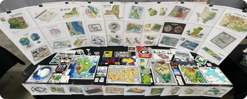
LEGO maps translate geographic information into a familiar and inviting medium. Colored bricks can represent elevation, water, land cover, political boundaries, or thematic data, while stacked layers turn flat maps into tangible landscapes. For children especially, the combination of maps and LEGO can make abstract geographic ideas easier to see and explore. It also encourages questions: Which areas of the map are higher or lower? What do the different colors represent? Where are the familiar cities located?
Sharing Maps with Local Families
Two local library exhibitions introduced these ideas in everyday learning spaces. From July 2 to 16, Exploring Geography through LEGO Maps appeared in the entrance display cases of the Sun Prairie Public Library, featuring selected physical LEGO maps and printed works. From July 7 to 16, an additional selection of physical and printed maps was displayed in the Children’s Area of the Oregon Public Library. Placing the maps in libraries allowed children and families to encounter geography while reading, browsing, and spending time together.
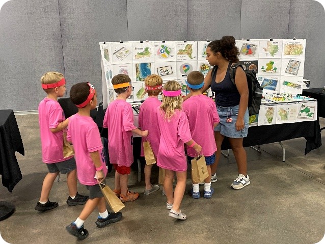
The collection also appeared at two community-centered LEGO events. At the Dane County Fair’s Kids Day Exhibition on July 17, children and families could view the maps up close and learn how familiar LEGO elements can represent real places and geographic patterns. Another display at Bricks & Minifigs Fitchburg brought the work to local residents and LEGO enthusiasts in a community space devoted to building and creativity. Together, the four display events reached audiences beyond those who would ordinarily attend a cartography conference or university lecture.
The Future of LEGO Cartography
Guo’s broader LEGO cartography practice has previously been featured in Esri magazine ArcUser, with additional works presented on his webpage. One of his most popular physical builds, LEGO Topographic Map of North America, was added to the American Geographical Society Library collection last year and, more recently, to the Library of Congress collection. These recognitions have expanded the project’s reach, while its local exhibitions demonstrate its value for community-based geographic education.
Looking ahead, LEGO cartography offers opportunities for exhibitions and educational activities in libraries, schools, museums, and community events. Its familiar and approachable form can encourage children to explore places, spatial relationships, and the ways maps help us understand the world. By extending cartographic knowledge beyond the university and making it accessible within local communities, these activities put the Wisconsin Idea into practice.