
SoLIM Approach to Soil Survey
The SoLIM approach employs recent developments in geographic information science (GISc), artificial intelligence (AI), and information representation theory.
Moving Beyond the Polygon Map Model
SoLIM products are different from the traditional soil survey polygon map because SoLIM characterizes soils for small pixels using a similarity model. Pixel size is dependent on the resolution of the environmental data, not on the map scale. Pixels can 10 meters on each side, or even smaller if environmental data at that resolution are available. SoLIM represents the soil at each pixel as a collection of fuzzy membership values. Each membership value provides the similarity of the pixel's soil to a known soil type. Thus the full set of values provides the membership of the pixel's soil in the various soil classes identified by the expert. This combined raster/similarity representation allows portrayal of soil as a spatial continuum rather than as a set of discrete, homogenous polygons.
Knowledge Documentation
SoLIM extracts and stores knowledge on soil-landscape relationships, saving it in a "knowledgebase." This knowledgebase is stored separately from the map in a highly readable format, which allows future soil scientists studying the area to easily reconstruct soil-landscape relationships. Thus, knowledge of soil-landscape relationships can be easily passed on from one generation to the next and can be conveniently updated and improved on by future soil scientists.
Automating the Mapping Process
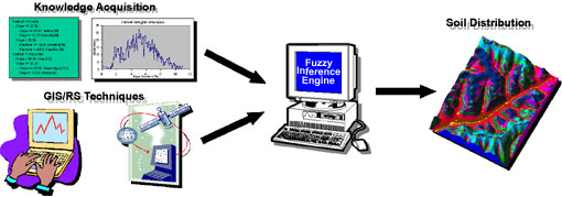
SoLIM automates the mapping process through the use of GIS techniques and a fuzzy inference engine. Environmental data layers related to soils, derived through a set of GIS techniques, are input into an inference engine. The inference engine combines the environmental data with knowledge extracted from soil experts or other sources and generates the soil similarity values (fuzzy membership values). The results are in georeferenced digital format and ready for analysis.
Summary
The raster similarity approach better expresses spatial and attribute information than polygon models. The automated mapping process improves the quality and consistency of soil information products and reduces the time needed to produce soil spatial information. The explicitly extracted and documented knowledge of soil-landscape relationships allows the knowledge to be accumulated over time and reduces the time needed to conduct future updates of soil spatial information. The modular design of SoLIM, i.e., the separation of environmental data layers (in the GIS) and the extracted knowledge (in the knowledgebase), allows each component to be updated independently and makes initial surveys and subsequent updates reusable. This not only saves time but also reduces costs, and thus significantly improves the efficiency of soil survey.
Next > SoLIM Results