
![]()
![]()
![]()
![]()
![]()
![]()
3dMapperTM is a landscape visualization and three-dimensional mapping application developed by James Burt and A-Xing Zhu at the UW-Madison Department of Geography. It allows researchers to quickly overlay topography with GIS data layers and draw lines, polygons and point data at arbitrary locations in the 3-D view. The program was written as part of the SoLIM project, funded by the USDA Natural Resources Conservation Service.
Features
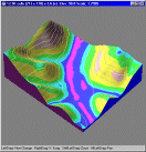
3dMapper presents users with a 3-D perspective view of the landscape, which users can quickly pan, magnify, and rotate. 3dMapper also allows users to exaggerate surface elevation for easy identification of changes in terrain. The program drapes a digital orthophoto on a digital elevation matrix, complementing phototone with a number of terrain-derived layers (contours, slope, curvature, etc.). Layers can be viewed alone or in combination, with or without synthetic illumination. A transect tool allows the user to easily view profiles with any orientation or level of complexity.
The program provides facilities for digitizing points and arcs on the 3-D view, and traces resulting lines as terrain-following segments. Editing functions are provided for both arc and point coverages, and existing coverages can be imported into 3dMapper from common GIS formats.
As a mapping tool, the program has many advantages over the conventional approach: it is much faster, it displays all environmental data on a common base (users can quickly cross-check interpretations made from different layers), it is highly interactive, and mapped data are captured in digital form at the outset, eliminating the need for manual transfer to base maps prior to scanning. The program runs under Windows 95/98/NT/2000.
Tutorial
A very clear 3dMapper tutorial has been prepared by the Idaho NRCS office. It explains how to download, install and use 3dMapper with many annotated graphical screens. It also shows how to prepare input data using Arc/Info. This page is strongly recommended for new users and the curious.
Downloading
The program is available by anonymous ftp at:
ftp://solim.geography.wisc.edu/OUT/jburt/3dMapper
The ftp directory contains the executable and a number of sample datafiles. None of the files are compressed, and no special installation is required. Simply copy the files to a directory of your choosing. The program makes no changes to the Windows registry. Program use and file formats are documented in the help file. The table below provides a complete listing of 3dMapper files.
|
Latest executable (required) |
|
|
Help file (required) |
|
|
Base dem/photo file for Pleasant Valley, WI |
|
|
NRCS soil survey polygons for Pleasant Valley |
|
|
Sample raster landform classification (color) |
|
|
Sample raster landform classification (grey scale) |
|
|
Streams and rivers for Pleasant Valley, WI |
|
|
Soil polygon labels |
Enhanced Version
The version of 3dMapper referenced above (the NRCS version) was developed as part of the SoLIM project. Since the completion of that part of the project in 2001, we have continued to add new features to 3dMapper in response to suggestions by users. The latest version contains the following features not present in the NRCS version:
a) Polygon topology and object editing
b) Shapefile import and export for points, arcs, polygons
c) Arc simplification (generalization) and smoothing (splining)
d) Partial arc move
e) Convert slope breaks to arcs
f) Cut and paste arcs between layers
g) Save local view as jpeg, gif or bmp
i) Print local view
j) Construct palette on raster input
k) Transparent slope classes
l) Undo function for editing layers
m) Automatic panning while digitizing
n) Hot-keys for shifting (panning) the local view
The enhanced version is available for trial at:
http://www.TerrainAnalytics.com