
![]()
![]()
![]()
![]()
![]()
![]()
CyberSoLIM
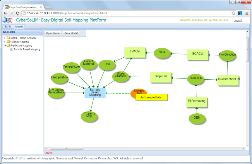
Back-ended with SoLIM, CyberSoLIM provides a heuristically driven, visually assisted, and high performance computing enabled cyber environment for digital soil mapping (DSM). Follow this link to get started with CyberSoLIM. Use the help menu on the upright corner of the screen after you have logon to the software system.
(Finally updated!!!, please let us know if you have questions. This version works in Google Chrome and Firefox)
SoLIMSolutions
The SoLIMSolutions software contains a set of tools for predictive digital soil mapping under the SoLIM framework and is available for non-commercial use. It contains the improvements over the earlier versions (SoLIM Suite and SoLIM software). Much of the work was funded by the Chinese Academy of Sciences and the USDA Natural Resources Conservation Service. It runs as a Microsoft Windows executable. Follow this link to obtain the software and associated materials (The Functionality Manual and Tutorial and tutorial datasets). Click here to access the online version of this Functionality Manual. Click here to obtain a copy of the Procedure Manual and click this link to download the example data sets associated with the Procedure Manual.
SoLIM Suite
The SoLIM Suite software contains a set of tools for predictive digital soil mapping under the SoLIM framework and is available for non-commercial use. Much of the work was funded by the USDA Natural Resources Conservation Service and the Chinese Academy of Sciences. It runs as a Microsoft Windows executable. Follow this link to obtain the software and associated materials (help manuals and tutorial datasets).
KnowledgeMiner (Data Mining Tools)
KnowledgeMiner is a spatial data mining tool set for discovering knowledge on soil-landscape relationships embedded in conventional soil maps. This tool set was developed as part of the SoLIM project. Currently the data mining tool set contains two programs: the KnowledgeMiner and the KnowledgeComparator. Follow this link to obtain the software and associated materials (help manuals and tutorial datasets).
3dMapperTM
3dMapperTM is a landscape visualization and three-dimensional mapping application developed by James Burt and A-Xing Zhu at the UW-Madison Department of Geography. It allows researchers to quickly overlay topography with GIS data layers and draw lines, polygons and point data at arbitrary locations in the 3-D view. The program was written as part of the SoLIM project. Follow this link to obtain the software and associated materials (help manuals and tutorial datasets).
ColorBars
ColorBars is a program which computes percetually even spaced colors for visualizing classification uncertainty. This program is to go with the paper published in Annals of GIS. Follow this link to obtain the software.