All lectures are presented fully online via Zoom every Friday at 3:30 PM. The link to join the meeting is https://uwmadison.zoom.us/j/99623736476
except when otherwise indicated. Brown bag sessions start at noon on
the days there are speakers. Alumni, friends and the public are always
invited to attend.
Fall 2019 Lectures
September 13 - Land Reform and the Green New Deal
Levi Van Sant
Georgia Southern University
Proponents of the Green New Deal in the US argue that the government
could simultaneously reduce inequality and the dangers of climate change
with a range of measures aimed at shifting towards renewable energy
sources. But at present very few of these proposals include significant
attention to land reform or rural places in general, despite the fact
that the politics of rural land was central to the original New Deal.
This talk uses the little-known and short-lived case of the 1970s
National Coalition for Land Reform, an effort to revive the radical
potential of the original New Deal, to examine the possibilities for a
national land reform movement today. Ultimately, I argue that land
reform is not only necessary for a “just transition†but that it has
the potential to connect, at least partially, the interests and desires
of urban and rural communities, as well as indigenous peoples, white
settlers, African diaspora communities, and (im)migrants. Such a task
would not be simple or smooth, of course. Yet, as the neoliberalism
originally forged in the 1970s faces its defining crisis in the present,
looking back to the national land reform movement of that decade offers
important lessons for efforts to build a Green New Deal today.
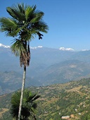
September 27 - Twenty-five Years of Forest Dynamics in Nepal
Jefferson Fox
East West Center
Since the 1980s, Nepal, one of the poorest countries in the world, has
gained worldwide recognition for its successful community forestry
program. Researchers, however, have not previously documented the
spatially explicit impacts of this forest transition because topographic
effects, e.g., shading, clouds, snow, and ice, have hindered
remote-sensing imagery analysis. This multi-disciplinary research
project built a comprehensive database of forest cover in Nepal
between1992 and 2016, identified the biophysical and socioeconomic
variables associated with change and quantified their respective
influences, and assessed how community forestry and foreign labor
migration and remittances affect forest cover change across the country.
October 4 - Spatial Social Network Analysis in GIS: A Case Study of the U.S. Mafia
Clio Andris
Georgia Tech University
Social network analysis is a powerful tool for learning about the
dynamics of partnerships, relationships and interpersonal systems. Given
that all social networks have an associated geography it follows that
these networks should be modeled in geographic space as a spatial social
network (SSN). If so, we can test for correlations between geographic
features and social ties to examine how one affects the other, and
describe new statistics for comparing networks over space and time.
Here, I will discuss best practices for collecting and modeling SSN
data, as well as new research questions for geographers. I use a case
study of a geolocated social network of 680 members of the U.S.
mafia. Connections between members represent ‘known associates’
found through a federal crime investigation by the U.S. Federal Bureau
of Narcotics in the 1960s. Each member is geolocated to a known
household address across 15 major U.S.cities, and concentrated in New
York City. Putting these data in a GIS environment uncovers new findings
about the strategies of the members and families. While this case study
is mostly descriptive, it also presents a number of research techniques
that can be generalized to other types of spatially-embedded social
networks.
October 11 - On the Origin of Sediment: Controls on Erosion and Weathering in Steep Mountains
Ken Ferrier
UW - Madison
The chemical and physical erosion of mountains help sustain life by
creating soil, shaping topography, and modulating atmospheric carbon
dioxide concentrations. Quantifying how chemical and physical erosion
rates depend on climatic and tectonic forcings is thus vital for
understanding Earth’s topographic and climatic evolution. Here I show
that chemical erosion rate measurements reveal a stronger dependence on
tectonic drivers than climatic drivers. I also discuss new model
results showing distinct responses of chemical and physical erosion
rates to climatic and tectonic perturbations, and describe their
implications for feedbacks between climate, tectonics, and topography.
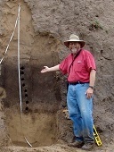
October 18 - Furrows Beneath the Forest: Ancestral Menominee Agriculture and the Future of MITW Food Sovereignty Initiative.
Bill Gartner
UW - Madison
Most academics and government agencies characterize ancestral Menominee
peoples as hunter-gatherer-fishers. Archaeological excavations and soil
analyses of relic raised fields on the Menominee Reservation, which are
part of the Menominee Indian Tribe of Wisconsin’s (MITW) Culture Camp
initiative, indicate that ancestral Menominee peoples also planted
fields maize, squash, and sunflowers by ca 850 AD. Ancestral Menominee
peoples developed a sophisticated agroecological system centered on
raised field agriculture and rotational agroforestry over the next
millennium. Moreover, they did so through several periods of
environmental change. The fur trade, settler colonialism, and the
post-reservation political economy largely obliterated traditional food
production by the 20th century. Today, the MITW seeks to produce local,
healthy, and culturally appropriate foods by reviving and modernizing
their traditional food production methods. The MITW hope to address
selected tribal health issues, provide economic opportunity, enhance
cultural revitalization efforts, and strengthen tribal sovereignty by
reclaiming local control over the means and relations of food
production.
November 1 - Trading Toxics in North America: Addressing Methodological and Conceptual Shortcomings in Current Explanation
Sarah Moore
UW - Madison
More than one million tons of hazardous waste are traded among Canada,
Mexico, and the United States each year. In addition to managing a
significant proportion of their own waste, all three North American
countries are now net hazardous waste importers. In this paper, I
present data and analysis that address a major methodological issue that
hampers current explanation of this significant and potentially harmful
trade: methodological nationalism. Data collection and analysis at the
scale of the nation-state obscures the complex local dynamics of the
trade, and its place-specific. I detail the work of a collaborative
multi-year research project to overcome methodological challenges and
provide novel understandings of the transnational hazardous waste trade
and its implications for the localities involved.
November 8 - Residential Income Segregation and Commuting in a Latin American City
Monica Haddad
Iowa State University
In this case study I examine the relationship between residential income
segregation and individual commuting time to work to understand spatial
inequality in access to jobs in the Global South, and propose policy
actions for enabling the urban poor to move out of poverty. Using a
sub-region of the Belo Horizonte Metropolitan Region (BHMR), in Brazil
as the study area, I address three main research objectives, covering
the period from 2000 to 2010: 1) examining residential income
segregation in the BHMR; 2) describing the spatial dynamics of changes
in commuting pattern over time (2000 to 2010); and 3) understanding the
relationship between commuting time to work, residential segregation,
and other urban characteristics. My findings lead to pro-poor
recommendations: expansion of the area devoted to a zoning category
‘Special Zone of Social Interest,’ and allocation of Transfer of
Development Rights revenues to social housing.
November 15 - Understanding Landscape Response to Environmental Change at the Grassroots Level
Joe Mason
UW - Madison
To understand geomorphic response to changing climate, vegetation, or
land use, we need to consider processes in the soil—literally at the
grass roots in many of the landscapes I work in—and we need to look
beyond short-term changes in water or nutrient supply to the effects of
longer-term soil development. I will discuss two projects providing
insight on the connections from environmental change through soils to
landscape response. One project investigated change in soils as forest
replaced tallgrass prairie over the past few thousand years in
northwestern Minnesota. This vegetation change (largely driven by
climate) has resulted in dramatic changes in soil morphology, which are
near-complete even close to the 19th century vegetation boundary. We
sought to estimate the timescale of this transformation using stable C
isotope and radiocarbon analysis, with some interesting and enigmatic
results. A new method for assessing microaggregate stability showed that
it is much lower in soils under forest than in the grassland soils,
which can help explain the morphological transformation after vegetation
change, but also has significant implications for potential erosion if
agriculture expands onto the forest soils as the present climate warms.
The second project, in its early stages though informed by work over the
past 20 years, also deals in part with effects of soil genesis under
grassland on subsequent susceptibility to erosion, in this case in the
loess tablelands and dune fields of the central Great Plains. We
hypothesize that shallowly buried soils, formed during periods of
relatively wet climate and limited aeolian activity, contribute to the
persistence of loess tablelands in a semiarid region with intense
rainfall, and to the relative stability of certain dunes that have
apparently escaped episodes of widespread activation in the late
Holocene.
November 22 - Programming a Carceral City
Brian J. Jefferson
University of Illinois - Urbana-Champaign
While US media has placed China’s digital surveillance apparatus under
increasing scrutiny, its US origins of this apparatus remain virtually
absent from these accounts. In addressing this deficiency, my talk
explores the rise and expansion of real time crime datacenters in US
cities over the past two decades. Focusing on New York City and Chicago,
the talk highlights how these datacenters fuse logics of computer
networking, security, and carceral governance into a distinct apparatus
designed to manage devalued populations in cities. I also explore the
limitations implicit to city efforts to program carceral urban spaces,
and how these efforts constitute a unique terrain for resisting racial
criminalization.
December 6 - How Maps Can Help Save the World: Visualizing SDG Indicators
Menno-Jan Kraak
University of Twente
The United Nations identified seventeen Sustainable Development Goals to
collectively address the most pressing problems facing our world in
relation to social, economic and environmental challenges. Each SDG has a
set of targets and indicators to assess progress across countries. To
achieve the goals, we need to understand each challenge and be able to
monitor progress towards alleviating it. Well-designed maps and diagrams
can assist in this process because they effectively reveal
spatio-temporal patterns, such as deforestation, and the environmental
and social challenges resulting from it. Maps can support
decision-making by local and national authorities as well as promote
public awareness of global issues to encourage these authorities to act.
However, many of the maps and diagrams about the SDG indicators are
produced without awareness of established cartographic design
guidelines. Flawed and misleading designs often result. Problems also
regularly originate from inappropriate data-handling, distracting base
maps, inappropriate map elements, and the (mis)use of software defaults.
In the presentation we will demonstrate these problems and discuss the
challenges we face to avoid them.