All lectures are presented fully online via Zoom every Friday at 3:30 PM. The link to join the meeting is https://uwmadison.zoom.us/j/99623736476
except when otherwise indicated. Brown bag sessions start at noon on
the days there are speakers. Alumni, friends and the public are always
invited to attend.
Spring 2020 Lectures
January 31 - Risky subjects: vulnerability and uncertainty in the global pesticide boom
Annie Shattuck
Indiana University
Globally, pesticide use is increasing significantly faster than food
production. The vast majority of the world's food producers depend on
pesticides, and most of those users live in the global south. I present
data from Northern Laos, until recently among the world's lowest per
capita pesticide users, to explore the everyday life of pesticides and
commodity agriculture as it transforms forests, local livelihoods and
health. Using oral histories, and socio-economic surveys, I look at the
relationship between modern agriculture, vulnerability, and
deforestation as old forest-based safety nets are ploughed under for
maize to feed growing meat consumption in China and Vietnam. I
interrogate the diverse -- and divergent -- set of partial knowledges
among pesticide users, and ask how small scale farmers' direct
experiences of toxicity both reinforce and transgress the international
model for safe use. I describe the ways that what counts as 'risky' and
'safe' is locally adapted, filtered through rural community dynamics,
and bound up with the other risks farmers are facing - the risks of
living at the precarious end of a global commodity chain.
February 7 - Data science approaches to improve water prediction and communication at the U.S. Geological Survey
Jordan Read
U.S. Geological Survey
Data growth and computational advances have created new opportunities to
improve water resource predictions and the delivery of water
information to managers and the public. The U.S. Geological Survey's
Water Data Science Branch has three primary goals: 1) improve
predictions by combining theory-based models with machine learning, 2)
create raw-data to decision-ready workflows that are reproducible, 3)
share insights with innovative and thoughtful data visualizations. This
talk will focus on the development and application of "process-guided
deep learning" towards predicting water temperatures in surface waters.
PGDLs are hybrid models that integrate process understanding into
advanced machine learning modeling techniques; research on PGDLs and
other hybrid modeling approaches continues to be a major research
component of the USGS Water Data Science Branch.
February 14 - Lady Dynamite's Spatialization of Bipolar Disorder
Marcia England
Miami University, Oxford
Depictions of those with mental health issues often frame them in terms
of pathology and deficit. However, the neurodiverse may have other ways
to frame their experiences and understandings of 'reality'. Loosely
autobiographical (based on the life of comedian Maria Bamford), Lady
Dynamite explores the everyday and fantastical aspects of living with
bipolar disorder. The Netflix series navigates the spaces of bipolar
disorder (both mania and depression) in its episodes and depicts bipolar
disorder as complex, yet manageable, rather than something to fear.
This series is a critical narrative to help in understandings of the
lived experience of those with neurodiversity. Scenes within the show
illustrate the complicated workings of bipolar minds and often depict
hallucinations (that once were private) as a shared visual between the
show and audience. Institutionalized spaces are juxtaposed with surreal
spaces to disrupt traditional narratives of time and space. The series
and its depiction of mental health changes the script on bipolar
disorder by focusing on normalcy of the protagonist's life. As such,
this portrayal of mental illness demonstrates a new and positive way to
discuss visual manifestations and norming of bipolar disorder.
February 21 - Mapping and data visualization at The Washington Post
Lauren Tierney
The Washington Post
At the Washington Post, reporters across the newsroom cover an array of
topics, from politics to climate change to natural disasters, all of
which involve conveying complex information to a broad audience. How
this reporting is communicated, through text, graphics and maps, or
photo and video, makes all the difference in disseminating reporters'
findings. Graphics reporter and cartographer Lauren Tierney will discuss
how the graphics team at the Post utilizes the power of visuals to
communicate complex data and concepts to readers, using maps, graphics,
and illustrations. She will also demonstrate how the graphics team works
with scientists and experts from a variety of academic fields to
communicate research visually to a broad audience.
February 28 - Defending Psychic Space: Blues Club Patrons Strike Out
David Wilson
University of Illinois Urbana-Champaign
Blues clubs today in Chicago's largely African-American, poor South Side
feel the winds of transformation as the city's redevelopment frontier
moves through this city section. Yet this calculated foray to transform
the city's poorest, most neglected, and stigmatized blocks and clubs is
being met with a sly, subterranean resistance. My talk chronicles this
resistance, focusing on the realities of a paradigmatic South Side club,
Beebe's. Long-term patrons, in particular, work through poverty and
de-humanization at every turn to constitute a coveted club and social
space using multiple, interconnecting templates (material concerns,
race-class identity-making, the drive for social enrichment). They seek
to build space and personhood here in response to a major force: to
chase away haunts that have been structured by historically persistent
regimes of socio-spatial isolation, identity afflicting, human
containment to shadowy city sections, and their recent placement within
punishing neoliberal sensibilities. The results take us beyond the now
standard story of such redevelopment machines as being blunt producers
of redevelopment and equally important, as engaging power-bereft people
on the ground.
March 6 - Civic Colonialism: Race, Gender, and the Politics of Municipal Annexation in Arizona
Anthony Pratcher II
Carnegie Mellon University
Scholars have overlooked how urban annexation drove the development of the metropolitan
Sunbelt in the American Southwest after World War II. A case study on civic life in 20th century
Phoenix shows how Anglo elites utilized municipal annexation to maintain colonial relationships
with racialized communities in the surrounding agricultural hinterland. Working-class Anglo settlers,
along with racial minorities and non-white immigrants, were largely excluded from participation in
civic activities as Anglo elites fought to remove these residents to the metropolitan periphery. Still,
civic elites could only extend their political control as far as the city borders, so after Phoenix voters
approved major postwar municipal bonds, civic elites annexed surrounding areas so that Charter
(the municipal political machine) could dictate development along the metropolitan periphery. While
metropolitan Phoenix enticed affluent homeowners with modern amenities and tolerable taxes, city
officials engaged in ruthless chicanery to convert, cajole, or coerce consent for annexation petitions
from right-wing populists. In contrast, Charter disenfranchised racialized residents to reduce
resistance to annexation in segregated communities. By 1960, just as in dozens of other Sunbelt
cities across the nation, municipal annexation allowed civic elites to amalgamate the metropolitan
periphery into their municipality. Metropolitan Phoenix, along with the broader American Sunbelt,
exists due to municipal annexation. This talk shows how this policy should be understood as a facet
within a longer a historical continuum of settler colonialism in the U.S./Mexico Borderlands.
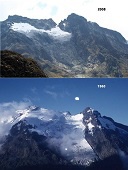
March 27 - How sensitive are tropical African mountains to climate change? - CANCELED
Jim Russell
Brown University
During the last century, tropical African mountain glaciers have lost
more than 90% of their surface area in response to climate warming.
Given present trends, we expect these glaciers to disappear within the
next few decades. How much have African glaciers and mountain
temperatures varied in the past, what were the impacts of these changes
on mountain landscapes and ecosystems, and what might these past
variations portend for the future? This talk will present new
reconstructions of climate, mapping and dating of past glacial extents,
and reconstructions of ecosystem processes from the Rwenzori Mountains,
Uganda-D.R.C. to address these questions.
April 24 - Mapping before, and without, 'Cartography' - CANCELED
Matthew H. Edney
University of Wisconsin-Madison
What is a map? After four decades of debate, map scholars have yet to
answer this question to their common satisfaction, which suggests that
they are perhaps asking the wrong question. We can instead answer
another question: what is cartography? Cartography appears to be the
universal, transcultural endeavor of mapmaking. Yet this conception
emerged only in the nineteenth century as an idealization - an
inadequate description and model - of actual mapping practices.
Moreover, an ongoing post-representational critique has yet to dispel
the ideal's culturally hegemonic status. Coeditor (with Mary Pedley) of
the newly published Cartography in the European Enlightenment, Volume 4
of the award-winning History of Cartography series, Edney explores how
to write the history of cartography before the formulation of the ideal
of cartography, and how this approach reconfigures the study of mapping
processes today without further succumbing to the ideal and its inherent
flaws.