
Enjoy the beautiful UW–Madison campus and network in-person while strengthening your competence in GIS applications and developing your cartographic design portfolio.
At a Glance
REQUIREMENTS
8 courses; 30-32 credits
TIME TO COMPLETE
as little as 3 semesters
CLASSES
In-person (some courses may be offered online)
TUITION
$900 per credit hour
WHEN TO START
Fall or Spring semester
PREREQUISITES
Undergraduate degree; 3.0+ GPA; 1 undergraduate statistics course
Find Your Place in Cartography & Geographic Information Systems
The world of cartography and GIS grows larger every day. If you love good design, interesting data, and challenging programming, the geospatial world might be a good fit for you—and we can help you learn all the techniques you need to be an expert in it.
To earn our in-person Accelerated/Non-Thesis Master of Science in Cartography & GIS, you’ll complete 30–32 credits, working through 4 preselected courses that build core GIS competencies and then choosing the electives that make the most sense for your personal career goals. These courses will introduce you to cartography, programming, mobile app creation, web map scripting, UI/UX design, geodatabase management, and more. With our strong focus on skill-building, you’ll earn your degree in as little as 3 semesters—no need to spend an extra year on research and thesis writing.
After you earn your master’s degree through this program, you’ll have the tools you need to start your career in the GIS world. You’ll have a deep and impressive portfolio that reflects your personal strengths and interests. And you’ll have access to our strong alumni network, giving you access to geospatial professionals across a wide variety of fields.
What You'll Learn

Cartography
Blend art and science as you design and develop maps that effectively communicate spatial data; create storytelling experiences that are interactive and mobile-friendly.

Spatial Data Analytics
Develop your competence in working with large geospatial datasets, processing and managing databases, and using analytical skills and techniques to solve pressing place-based problems.

GIS Programming
Build scripting and programming skills using industry-standard tools including Esri ArcPro, QGIS, and Python.
Courses
To earn our accelerated/non-thesis master’s degree in cartography & GIS, you’ll complete 30-32 credits. You’ll earn 16 credits in 4 core courses, and 14–16 credits in elective courses.
Core Courses
Geog 370 Intro to Cartography (4 credit hours) – offered every semester
Geog 377 Intro to GIS (4 credit hours) – offered every semester
Geog 378 Intro to Geocomputing (4 credit hours) – offered in the fall
Geog 778 Practicum in GIS Development (4 credit hours) – online only
Elective Courses
Geog 560: Advanced Quantitative Methods (3 credit hours)
Geog 572: Graphic Design in Cartography (4 credit hours) – offered in the fall
Geog 573: Advanced Geocomputing and Geospatial Big Data Analytics (4 credit hours) – offered in the spring
Geog 574: Spatial Databases, (4 credit hours) – offered in the fall
Geog 575: Interactive Cartography & Geovisualization (4 credit hours) – offered in the spring
Geog 578: GIS Applications (4 credit hours) – offered in the spring
Geog 579: GIS & Spatial Analysis (4 credit hours) – offered in the fall
**Please note: This is a general guideline only. Course offerings may vary each year.
Curriculum Tracks
With our deep knowledge of the industry and our curriculum, we’ve put together three suggested curriculum tracks. The ultimate choice in what to study is yours, but these tracks may help you formulate your plan.
Geospatial Data Science Track
Your primary goal is building expertise in geospatial data science techniques and the programming skills needed to implement them. You’re interested in extracting insights from big geospatial data and solving place-based problems using spatial data analytics, modeling, AI and machine learning, geospatial database design, geovisualization, and more.
Courses in this Area:
Geog 560: Advanced Quantitative Methods
Geog 573: Advanced Geocomputing and Geospatial Big Data Analytics
Geog 574: Spatial Databases
An additional elective that serves your needs
Cartographic Storytelling and Geovisualization Track
Your primary goal is enriching your design skills and applying them to geospatial data sets using state-of-the-art tools and techniques. You’re interested in producing impactful and aesthetically pleasing digital maps and interactive geovisualization tools, leveraging the most up-to-date UI/UX design principles and best practices in project management.
Courses in this Area:
Geog 570 (currently listed as 475): Cartographic Production & Project Management
Geog 572: Graphic Design in Cartography
Geog 575: Interactive Cartography & Geovisualization
An additional elective that serves your needs
GIS Methods and Applications Track
Your primary goal is developing a robust understanding of the theoretical underpinnings of GIS methods and geostatistical techniques needed to solve some of the world’s most pressing problems. You’re interested in leveraging a wide range of analytical methods to make inferences about spatial distributions and transform geospatial datasets into place-based insights.
Courses in this Area:
Geog 560: Advanced Quantitative Methods
Geog 578: GIS Applications
Geog 579: GIS & Spatial Analysis
An additional elective that serves your needs
"For a position where I’m acting as the resident expert in my field, a specialized program that I could design to fit my career interests was crucial."
Ellie Glynn, accelerated master's program graduate
Who You'll Meet
Students in our accelerated/non-thesis master’s degree program represent a wide variety of career paths and interests, including archaeology, urban planning, law enforcement, surveying, engineering, environmental studies, and much more. As a student, you’ll be able to connect with fellow students and past alums to deepen your connections in the GIS world and grow your professional network. Read about some recent accelerated/non-thesis master’s degree students and why they joined the program:

What You'll Work On
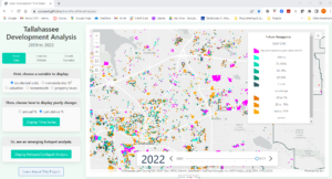
One key strength of our program is its focus on building your portfolio—something tangible you can use to demonstrate your specific skills and interests to potential employers. You’ll create many portfolio-worthy projects throughout your time in the program, but in Geog 778, Practicum in GIS Development, you’ll create something particularly special. Students in this final class take all the knowledge they’ve gained from our program and fuse it with personal, real-world subject matter. End result? Every 778 student walks out of the classroom (or whatever home office or coffee shop they’ve been working in) with a substantive portfolio piece they can talk about with pride. See a few examples below, and then explore more.
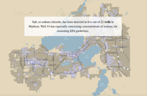
Randi Selvey | Protecting Madison’s Freshwater
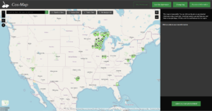
Mallory Johnson | Cos-Map

Finding Your Future in GIS
Geographic information systems make a difference in countless industries—transportation and navigation, environmental science and conservation, engineering, surveying, health and epidemiology, archaeology and history, and public safety, just to name a few. Cartography and GIS is a 350 billion dollar industry that employed an estimated 625,000 Americans in 2010; today, 5 million U.S. employees rely on geospatial services to perform regular job duties. The U.S. Bureau of Labor Statistics estimates 5% employment growth for cartographers between 2022 and 2032—faster growth than in other industries.
Earning our accelerated/non-thesis master’s degree in cartography & GIS sets you on the path to success in the ever-evolving and expanding area of cartography and geospatial technology. Perhaps you’ll seek a GIS Analyst position with a non-profit, end up as a GIS Project Manager for a government agency, or find your place as a GIS Software Developer for a corporation. With the skills you’ll learn here, there’s no limit to where you can go.
Interested in learning more? See some examples of GIS professionals at work.
Studying Cartography & GIS at UW–Madison
We take great pride in our technology-centered curriculum and how it bridges the gap between cartographic design and GIS development. We take even more pride in our instructional team, built of internationally recognized faculty and geospatial industry experts.
But our program is about more than what happens during your 30–32 credit hours. We’ll give you opportunities to connect with students in all of our programs and working professionals in our alumni network. And Map Chat, our informal monthly lecture series, brings you talks with experts from all corners of the geospatial and cartography world.

Exploring the UW–Madison Geography Department
Being an in-person student means networking in-person with your peers, as well as the faculty and staff of one of the top ranked geography departments in the nation. It also means taking advantage of the extraordinary resources available on the UW–Madison campus.
Start in the Cartography Lab —it’s a unique maker-space where researchers, professional designers, and students work together to discuss complex problems and create compelling visuals. Here, you’ll find all the newest technology and people to talk about maps with. Then, find your way to the Robinson Map Library. It contains ~260,000 historic aerial photos of Wisconsin; it also manages and archives a significant collection of digital geospatial datasets. Or, spend some time chatting with members of the Wisconsin State Cartographer’s office. They support the state’s geospatial community and can share the latest info about events, jobs, and emerging trends.
Gaining Practical Experience
Those unique units in the Geography department—the Cartography Lab, Robinson Map Library, and the Wisconsin State Cartographer’s office—all work on unique real-world projects and problems.
To help those units achieve their aims, and to help our students expand their professional experience and capabilities, we support a small number of paid, semester-long student fellowships each year. If you apply for and earn one of these fellowships, you could do hands-on GIS work in cartographic production, archiving, data integration, technical consulting, and much more.
Students in this program are not considered for teaching assistant or research assistant positions in the Department of Geography.


Getting a Head Start with Transfer Credits
We value GIS and cartography work that you’ve completed elsewhere, and we’ll do our best to honor that work. The accelerated/non-thesis master’s program allows you to transfer in credits from the following sources:
• Undergraduate course credits from UW–Madison: up to 7 credits.
• Graduate course credits from UW–Madison or other institutions: up to 7 credits. If the course credit comes from another institution, we will review to ensure the rigor and learning goals align with the course in our curriculum.
• University Special Student credits from UW–Madison (GIS Fundamentals Capstone Certificate and/or Advanced GIS Capstone Certificate courses): up to 15 credits.
Per Graduate School policy, any prior coursework must have been rigorous and meet the expectations of graduate work for the program. Coursework earned five or more years prior to admission to a master’s degree will not satisfy requirements. Visit the Graduate Guide for more detail regarding credit transfers and program requirements. Please note that you should discuss potential transfer credits with your advisor when you join the program.
Applying to the Accelerated/Non-Thesis Master’s Degree in Cartography & GIS Program
We’re thrilled that you’re interested in joining our program. You’ll need just a few things: your resume, unofficial transcripts, contact info for 2 professional or academic references, a statement of interest that walks us through your career goals, proof of English proficiency (for international students only), and a $75 application fee (closer to $85USD for international students).
Learn more about our process, including application fee grant/waiver opportunities, and get started on our Apply Now page.
This is an accordion element with a series of buttons that open and close related content panels.
Fall Semester Application Deadlines
• First Consideration: April 1
• International Students: April 1
• Final Deadline: June 1
Spring Semester Application Deadlines
• First Consideration: August 1
• International Students: August 1
• Final Deadline: October 1