What is the GISPP?
Launched in 2016, the GIS Professional Programs, or “GISPP”, encompass our non-thesis design and technology degrees in Cartography & GIS. Specifically, the GISPP offers two MSc degrees, one online emphasizing GIS development and web map programming, and one on campus, allowing students to complete our resident Cartography and GIS courses in just one year. We also offer two, three-course online capstones in GIS fundamentals and advanced GIS topics. For more details about our GIS Professional Programs, see: https://geography.wisc.edu/gis/
Now in our seventh year of operation, the GISPP is pleased to announce that we expect to surpass *200* GISPP MSc graduates as of this Spring 2023 semester! In total, the GISPP has graduated 159 students from the Online Master’s in GIS Development, 37 from the In-Person Accelerated / Non-thesis Master’s, 55 from the Fundamentals Capstone, and 29 from the Advanced Capstone—well exceeding our original expectations! We encourage you to join this growing alumni network and contact us at: https://uwmadison.co1.qualtrics.com/jfe/form/SV_54JGFE8ohslqdtr
New Faces in the GISPP: Welcome Dr. Jonathan Nelson, Incoming Director!
We are pleased to welcome Incoming Director Dr. Jonathan Nelson, who will be taking over the reins of the GISPP this summer. Dr. Nelson studies geographic information science, specializing in cartography, geovisual analytics, and human-centered design with applications in environmental science, fitness and health, politics, socioeconomics, transportation, and urban planning. Dr. Nelson brings many years of professional experience to the Directorship, including work in academia as Director of the Penn State Center for Environmental Observation and Instructor in the Penn State Online Geospatial Education Program as well as work in the industry at National Geographic Society and Strava Metro. As Associate Director the past academic year, Dr. Nelson has been shadowing Dr. Robert Roth—who has been serving in an Interim Director role since 2021—on all GISPP operations and is ready to hit the ground running on new initiatives this summer!
Read more about Dr. Nelson at: https://geography.wisc.edu/gis/meet-our-people/faculty-staff-spotlight/jonathan-nelson-assistant-professor-of-gist-and-associate-director-of-gis-professional-programs/

Student Highlights: Projects from Geography 778!
Dr. Nelson has been teaching Geography 778 for the past two semesters, which enrolls students in both the Accelerated / Non-thesis Master’s in Cartography & GIS and Online Master’s in GIS Development degree programs during the final semester of study. In this course, students draw upon geospatial concepts and skills obtained throughout their time in the program to conceive, design, and implement map- and GIS-based projects with real-world applications. As part of the project development and documentation process, students connect with academic and professional mentors, draft detailed project plans and status reports, record an elevator pitch, create wireframes and mockups, and conduct user testing exercises. Final deliverables for the course include a project demonstration video, executive summary and abstract, and digital portfolio showcasing the students’ mapmaking and GIS achievements. An overarching goal of GISPP is to position students for growth and success in a broad range of geospatial career paths, and courses are designed to not just equip students with the necessary skills and tools but to create a compelling record of their growth through projects that directly translate to strong portfolio pieces.
Take a peek at a couple examples of what students are able to accomplish upon completion of the GISPP MSc degrees in Cartography & GIS!
Example #1
Student Name: John DeLoretta
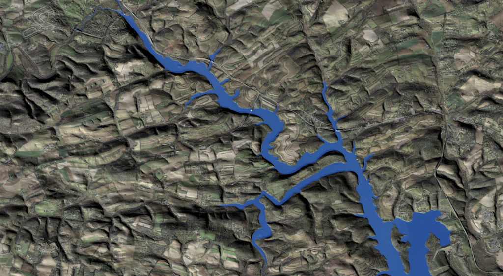
Project Title: Watershed Study at Blue Marsh Lake for Blue-Green Algae Prevention
Student Abstract: This project serves two purposes: to educate the public on blue-green algae, and also to help park rangers at USACE Blue Marsh Lake in Leesport, PA identify locations within contributing watersheds to install Best Management Practices (BMPs) in order to reduce excess nutrient runoff entering the waterways. This website is split into two pages to achieve each of those goals. The public can scroll through a narrative page to learn about formation, identification, health impacts, and current management practices of blue-green algae at the lake. The second page is an interactive web map that allows users to see topography, streams without vegetated buffers, soil erodibility rates, nitrogen and phosphorus loading rates, and also the estimated nutrient reduction per drainage basin of installing various BMPs of a location where they click.
Example #2
Student Name: Michael Hasinoff
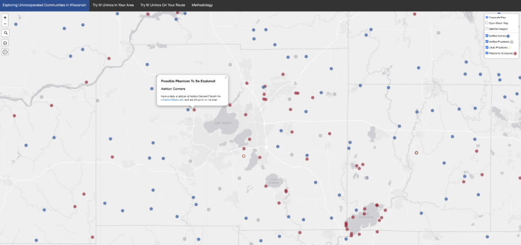
Project Title: Identification of Mapped, Yet No Longer Existing Unincorporated Communities (Phantoms) In Wisconsin
Student Abstract: Upon close inspection of online maps, labels for non-existent unincorporated communities are common. These “Phantoms” are found because websites such as Google Maps use the US Geological Survey (USGS) topographic maps and its Geographical Names Information System (GNIS) as main sources of map data. Due to a paucity of resources, the USGS has not thoroughly rectified these inaccuracies and therefore, over time, Phantoms have persisted on their maps. Using residential parcel records from the Wisconsin Statewide Parcel Map, a methodology was developed in ArcGIS Pro that identified ~60 Phantoms from a list of ~625 unincorporated communities curated from the GNIS. With ground-truthing, most of these can be easily confirmed as Phantoms and subsequently presented to the USGS for appropriate re-symbolization or removal from US topographic maps. This approach can be viewed as a first step for updating maps of Wisconsin and the rest of the United States.