By Michael Hasinoff and Howard Veregin of the Wisconsin State Cartographer’s Office
In 1976, local conservationist, preservationist, writer and assistant to the Wisconsin DNR secretary, Walter Scott, wrote, “Without question, the Madison area has a rich heritage in these venerable [oak] trees which are a living link with our past and [a] challenge for the future.” Scott thereby initiated what is now called the Heritage Oak Project as a nod to both the previously dominant oak communities native to Dane County and the U.S. Bicentennial of our country’s independence. With an appeal to newspaper readers and the help of others, Scott attempted to identify as many 200 year or older oak trees as possible within an eight-mile radius of the Capitol.
Scott was successful in recording the measurements and locations of 443 oak trees on both public and private land. In 2001, arborist Bruce Allison (then of the Dane County Tree Board) traced Scott’s footsteps and determined that approximately half of these oaks remained alive while the other half had died of old age, been cut down for new development, or simply could not be located due to inaccurate location descriptions. While Allison took inventory of the oaks, he used GPS technology to log their exact location to make future work easier.
Today, the Tree Board, the Capital Area Regional Planning Commission (CARPC) and the University of Wisconsin State Cartographer’s Office are continuing Scott and Allison’s work by collaborating on a third round of inventorying what remains of the original list of oaks. With limited resources, visiting these oaks that are now 250 years or older remains a work in progress. That said, please take a look at our website and the Interactive Heritage Oak Map to see what we have already done!
Scott’s words are as true today as they were in 1976 when he also wrote, “How many [oaks] can we preserve for the Tricentennial in 2076? This would require a determined effort to keep them alive and well along with a willingness to allow for a place for them in an environment rapidly filling with asphalt and concrete developments.”
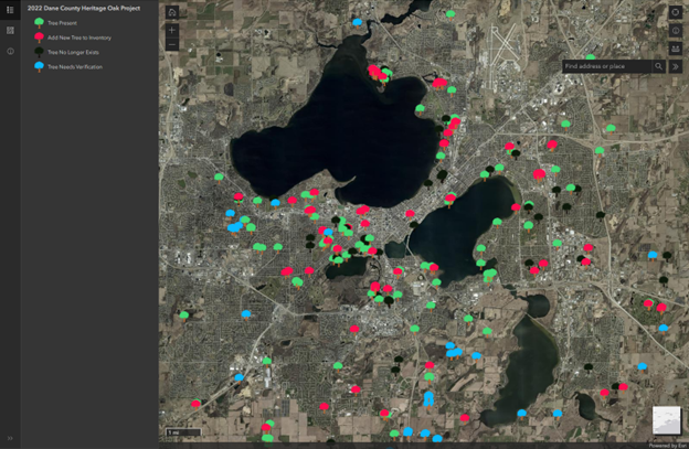
Heritage Oaks Project Interactive Map
We and our collaborators are now reaching out to the public to help us in this effort. There are still many specimens of once ubiquitous oaks (now Heritage Oaks!) that are not inventoried and remain scattered throughout city streets, backyards, parks, farmland, and forests of Dane County. There are simply too many oaks that are too far apart for us to log without outside help. By engaging the public through crowdsourcing, not only are we trying to add as many of these oaks as possible to the Heritage Oak Project inventory, but we are also trying to instill awareness, pride, and stewardship of these oaks at both the individual and community levels. Initiating these efforts has included word of mouth, blogs, and updates such as the one you are reading now. Also key to our efforts has been the creation of postcards directing the public to our website and interactive map. Distribution of these postcards includes focused mailings, and delivery by local arborists as they visit customers. We are also looking to leave them at locations such as libraries and nature centers.
On our postcards we appeal to the public (that includes you!) for help in the following ways:
- Landowners may have a Heritage Oak on their property that is already on Scott’s original list. If so, they can head to our website and help us update the information we have for it on our map.
- The public may know about a Heritage Oak that is not already in our inventory. If so, they can help us add it to our map.
- Spreading the word(!) by telling friends and neighbors about our project.
- Protecting their oaks! Not only do these oaks provide environmental and economic benefits to the communities we live in, but they are also living, natural, historical artifacts.
When the public gets to our website, they will see much of the same information described above as well as tips on how to identify, measure and add their oak to the Interactive Heritage Oak Map. Links to the history of the project and how to care for their trees are also included.
While the third iteration of this mapping project moves forward, the collaborators on this project have been looking at other opportunities where it can be a steppingstone to other projects in the county and state. For example, in the fall of 2022, acorns from native trees in the Heritage Oak Project were collected and, in the future, the seedlings will be made available for distribution by the Department of Natural Resources, thereby maintaining the lineage of these native oaks. Other brainstormed opportunities include working with schools (do you remember getting that pine tree seedling in first grade?), private and public land management programs, as well as urban forestry and tree equity projects.
Please contact us with any comments or questions at oaks@sco.wisc.edu. And lastly, keep a watch out for possible Heritage Oaks in your community and make sure that they find their way onto our map into our inventory!


