
Stoltenberg_MapLibr08_563
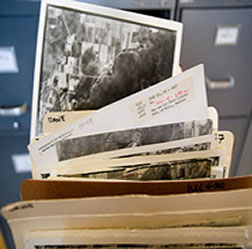
On Sept. 5, 2008, librarian Jaime Stoltenberg looks through a rare collection of the oldest aerial photos of the state of Wisconsin, taken by the USDA from 1937-1941 and now stored at the Arthur H. Robinson Map Library in Science Hall at the University of Wisconsin-Madison. The Department of Geography and UW Digital Collections Center at Memorial Library are co-recipients of a 2008 Ira and Ineva Reilly Baldwin Wisconsin Idea Endowment grant to digitize the collection and create a Web portal to make the content more publicly accessible.
©UW-Madison University Communications 608/262-0067
Photo by: Jeff Miller
Date: 09/08 File#: NIKON D3 digital frame 563
Leave a Reply
You must be logged in to post a comment.