
Geographical Maps and the Public Sphere
An in-depth look at the importance of maps for public debate about everything from art criticism to politics, highlighted in our 2022 Outreach Letter.
The heart of modern democracy is the “public sphere.” The public sphere comprises many forums in which people come together and debate all sorts of matters, and in doing so they constitute the “public.” The public sphere comprises both physical spaces where people meet face-to-face, and virtual spaces in which people debate through the medium of print and, in the last two decades, that of social media. How people have participated in these forums and in doing so have acquired political power, how they made those forums, and how those forums have developed over time are all very complex topics that have been studied and illuminated by a wide variety of historians, philosophers, political scientists, sociologists, historians of science, and geographers. This essay adds to the discussion by exploring the role of geographical maps and mapping in the formation and subsequent development of public debate and the public sphere.
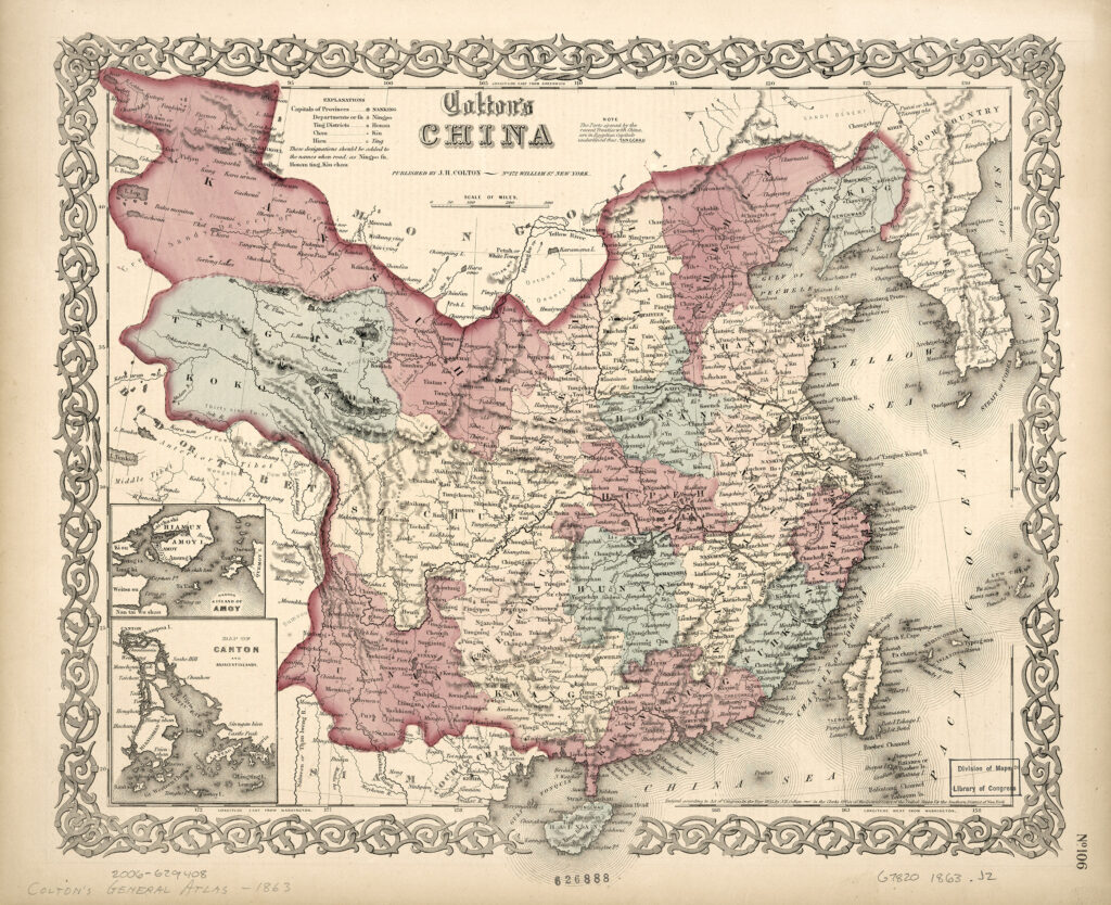
From a mapping perspective, the history of the public sphere is a history of changing attitudes towards maps. Changes in mapping practices over time are not simply driven by technological, scientific, cultural, or social change. Rather, geographical mapping is itself a key ingredient in the organization of society. Geographical maps are those that show the world, the continents, and political divisions at relatively coarse resolutions (fig. 1 below), as distinct from sea charts and more detailed topographical and urban maps, among other mapping modes. The nature of the public sphere has been shaped by how printed geographical maps were understood and used by the public, first as it emerged in the seventeenth and eighteenth centuries, and then as it developed new configurations in the nineteenth-century age of mass literacy.
Figure 1. A “typical” geographical map. Colton’s China, from Colton’s General Atlas (New York: J. H. Colton, 1863). Hand-colored steel engraving, 32 × 38 cm. Courtesy of the Geography and Map Division, Library of Congress (G7820 1863 .J2). Click on image to view in high resolution.
This essay explores these points in five stages:
- an explanation of the idea of the public sphere by reference to early writing about geographical maps;
- a history of the public sphere in early modern Britain and British North America, offering some detail to demonstrate the complexities involved;
- a consideration of the contributions of geographical mapping to public debate in the early modern era;
- tracing the changing nature of the public sphere and geographical mapping in the nineteenth century, especially with reference to the USA; and
- some reflections in conclusion about the study of maps in society.
This is a long essay, but then it deals with a fascinating and little understood aspect of map history and it gives some insight into our democratic principles. It deserves a full treatment. Even so, the essay can only be a partial account of the changing public sphere. I necessarily focus on the Anglophone experience, and I invite readers to extend the subject and to consider in detail mapping within other public spheres as they emerged and developed in other countries.
(The short version: the study and appreciation of early maps and mapping marks a particular social group within the public sphere. Our social group, our intellectual community, is sustained in part by supporting The History of Cartography. Large or small, gifts to the History contribute to maintaining the intellectual community, so please make a donation. Thank you.)
The Idea of the Public Sphere
The German philosopher Jürgen Habermas (1989 [1962]) identified the emergence of the public sphere in the seventeenth and eighteenth centuries as the foundation of modern, Western democracy. Habermas’s work has inevitably attracted a large corpus of commentary, revision, interpretation, and critique (see, esp., Calhoun 1992; Robbins 1993; Mah 2000). In particular, historians have significantly rewritten Habermas’s chronology and mechanisms of public speech; the following reflects those later studies. [n1]
The basic idea is that before 1650 or so, European societies were largely divided in their political activities. On the one hand, there was the domain of the state, which is to say of sovereignty, authority, and government. This domain comprised a small group of royalty, nobility, and gentry who debated and set policy in a series of private places (royal courts, law courts, and parliaments [also known as courts]). Policy encompassed not only religious, military, and tax affairs, but also cultural affairs, as courtiers established standards of taste in dress, art, writing, and food. On the other hand, there was the domain of private, economic life, of commodity exchange and labor. This domain was formed by the unprivileged mass of people who were excluded from the affairs of state. They adhered to the systems established by states, following officially approved religion or using statute weights and measures, for example, without having a say in setting those systems and the policies that underpinned them. Dissent was, of course, common, as people held unapproved rites or used customary measures in local trade, but carrying on such dissent in the open was a recipe for punishment by the state.
But, in the decades after 1650, the wealthier members of the general populace—who in England were often called the “middling sort”—increasingly claimed a say in setting policy, which is to say that they claimed a right to engage in politics. The result was the formation of the public, or “civil society,” that engaged in public debate. Public debate has the goal of constructing and refining a “public opinion” that influences and regulates the activities of both private life and the state. To function in this manner, the public sphere requires, and demands, publicity, which is to say making public knowledge that is otherwise restricted to either private life or the state. The public sphere therefore constituted a new social arena that mediates between the state and private life. As such, it provides an integrative and democratic forum free from the state’s authoritarianism and the mob’s violence. Eventually, beginning with the American, Haitian, and French revolutions at the end of the eighteenth century, the public achieved actual political power.
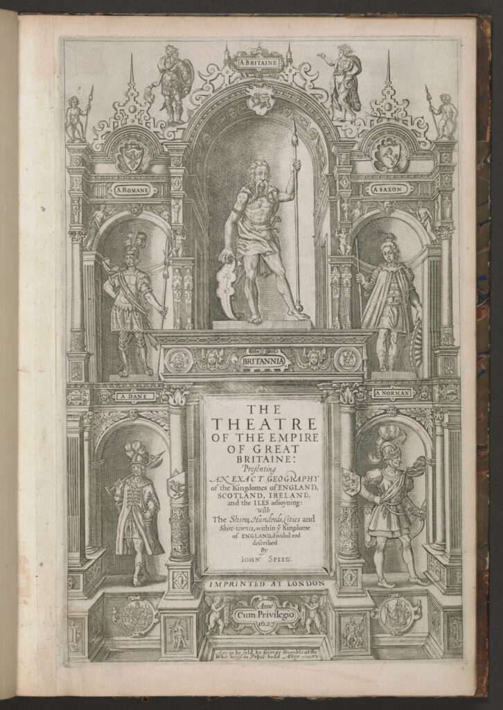
Figure 2. Engraved titlepage to John Speed, The Theatre of the Empire of Great Britaine (London, 1627). Copper engraving, 42 cm high. Courtesy of Stanford University (STC (2nd ed.) 23042). Click on image to view in high resolution.
We can see this profound change in the dedications of two atlases produced in London and generally credited to the English antiquary John Speed (fig. 2 above). Speed published his first atlas, The Theatre of the Empire of Great Britaine, in 1611/2 [transcription] [images]. It was a folio atlas of “Great Britain” that followed the same general format as Abraham Ortelius’s Theatrum orbis terrarum (Antwerp, 1570) [images]; that is, it featured a series of engraved maps accompanied by textual accounts of the regions depicted. Ortelius had originally made a composite map collection as a way to assist a client in keeping up with news of European wars and in assessing transportation costs; he soon thereafter organized the publication of the collection in a standardized format, as the Theatrum, specifically as a contribution to historical study (in general, see Broecke et al. 1998). As he introduced his address to the reader:
All [lovers of histories] will readily affirm with us how necessary is the knowledge of regions and provinces, of the seas, the location of mountains, valleys, cities, the courses of rivers, etc., for attaining [a full] understanding of histories. This is what the Greeks called by the proper name “geography,” and certain learned persons (rightly) call “the eye of history.” (Ortelius 1570, sig. Aiiij) [n2]
Ortelius’s contemporaries further expressed the view that geographical texts also served as an intellectual surrogate for travel. For example, Wye Saltonstall suggested, in his preface to his translation of a Dutch book of world geography, that his readers would intellectually enjoy the “eye-travel” permitted by the work’s texts and maps. Salstonstall further thought that his readers would use the maps and texts to clarify the works of poets and historians. He did admit to the political significance of geographical knowledge, but he limited that use to the specific sites of Parliament and the royal court (in Hondius 1635, xi). Before about 1650, geographical works contributed primarily to private, economic, and intellectual life; only a few of their readers could be expected to use the maps as a foundation for debating and setting government policy.
Speed made these same points in dedicating the first edition of The Theatre of the Empire of Great Britaine to James I of England, VI of Scotland, indicating the confinement of instrumental geography to courtly society:
To the most high, and most potent monarch, Iames, of Great Britaine, France, and Ireland king; … inlarger and vniter of the British empire; restorer of the British name; establisher of perpetvall peace, in chvrch, and commonvvealth; president of al princely vertves and noble arts. (Speed 1611, unpag. front matter; reprinted Speed 1676, ix-xvii)
The commendatory verses that followed the dedication all emphasized the atlas’s geographical and historical packaging of the islands for easy intellectual comprehension by non-courtly readers.
Speed later prepared a series of maps of parts of the rest of the world, which he first issued as a set in 1627, although no copy seems to survive. After Speed’s death in 1629, the maps were reissued in 1631 under the title, A Prospect of the Most Famous Parts of the World [transcription]. The Prospect was apparently understood as a supplement to the Theatre. Stand-alone issues of the Prospect feature no dedication, and the two works were often reissued together, as either the Prospect containing the Theatre, or as the Theatre containing the Prospect. The last edition of the combined works was issued in 1676, after the cultural and political upheavals of the English Civil War, of Oliver Cromwell’s Commonwealth, and of the restoration of Charles II in 1660 (see Skelton 1966; Baynton-Williams 2022). In addition to some new maps, editor Edward Phillips wrote an expansive new front matter, in which he dedicated the work to the lord mayor, aldermen, and sheriffs of London. The dedication understood the merchants as having an active, instrumental engagement with geographical maps:
To whom more fitly should the Prospect of the Earths rich discoveries both by Land and Sea present it self, than to the Magistracy of a Famous City, that extends her Traffick and Commerce to the utmost Shores of the two Opposite Indies; to whom more properly the Description of our own Countrey, than to the Powers of that Supreme City, whose prosperous Trade distributes Wealth and Honour to the whole Nation, advancement of Revenue to our Soveraign, and a large supply of Things useful and necessary even to the most Fertile of Forreign Regions? (in Speed 1676, vii)
Phillips revealed a new awareness of the fundamental utility of geographical knowledge to the emergent public; he no longer restricted that utility to the sovereign and to officers of state. For Phillips, geography comprised a prominent category of useful knowledge which had to be made public; if not immediately useful when purchased, geographical texts and maps nonetheless had the potential to be “deployed usefully” (Brewer 1990, 228).
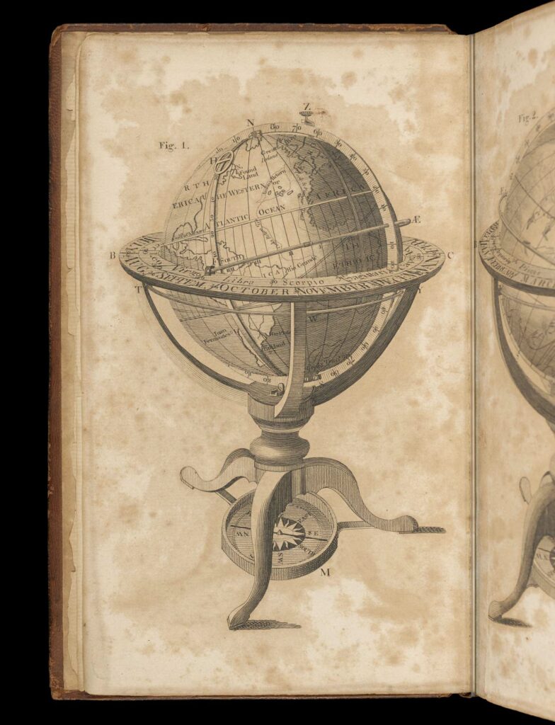
Figure 3. Image of a terrestrial globe, from George Adams, An Essay, on the Use of the Celestial and Terrestrial Globes, 4th ed. (Philadelphia: William Young, 1800), frontispiece. Courtesy of the Osher Map Library and Smith Center for Cartographic Education, University of Southern Maine (Smith Collection). Click on image to view in high resolution.
A century later, when public debate was well entrenched, the mathematical instrument maker George Adams sought the approval of George III in dedicating to the king his Treatise Describing and Explaining the Construction and Use of New Celestial and Terrestrial Globes (fig. 3 above). The dedication, which has been attributed to Samuel Johnson (Griffin 2014, note 73), exclaimed that
Geography is in a peculiar manner the science of princes. When a private student revolves the terraqueous globe, he beholds a succession of countries in which he has no more interest than in the imaginary regions of Jupiter and Saturn. But Your Majesty must contemplate the scientifick picture with other sentiments, and consider, as oceans and continents are rolling before You, how large a part of mankind is now waiting on Your determinations, and may receive benefits or suffer evils, as Your influence is extended or withdrawn. (Adams 1766, [iv]–[v]; see Wallis 1978, 107; Wallis 1980, 461)
Yet the sentiment was out of date! The days were long past when maps were instrumental devices solely for kings and princes, and when everyone else looked on maps as intellectual works. If anything, the dedication of Adams’s treatise was a back-handed claim that the middling sort—to whom the book and globes were directed—had actually acquired a princely status through their increasing ability to debate and shape religious, military, diplomatic, social, and cultural policy.
The Growth of the Public Sphere in Britain
While the basic premise of the public sphere is simple, it has manifested in many forms, each with their own particular histories (Habermas 1989 [1962], 57–73; Baker 1992, esp. 183; Jacob 1994). [n3] The public sphere features multiple sites where private individuals come together to deliberate upon issues of common interest in a critical and rational manner. These sites established a new sociability that disregarded social rank and status of individuals, promoted an equality of congress, and encouraged the impartial evaluation of arguments according to their logic and evidence. The sites of public debate were in part personal: coffee houses in England; masonic lodges in the Netherlands and Germany; and salons in France. More generally, public debate took place within the expansive medium of the printed word. Printed texts, widely distributed, make up a virtual forum within which readers and writers from all stations in life can engage in sociable and rational critique. Thus, the meaning of the word “publication” changed, from the act of making an announcement to an assembled crowd, such as reading aloud the text of an act of Parliament, to the act of printing and indiscriminate distributing a work. Daniel Defoe captured this transformation when he exclaimed that “preaching of Sermons is speaking to a few of Mankind; printing of books is talking to the whole world” (Defoe 1704, unpaginated preface, emphasis added).
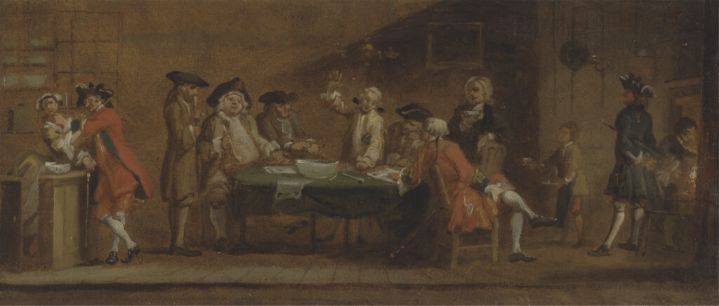
Figure 4. Joseph Highmore (attrib.), “Figures in a Tavern or Coffee House” (ca. 1725 or after 1750). Oil on panel, 20 × 46.5 cm. Courtesy of the Yale Center for British Art (Paul Mellon Collection, B2001.2.86). Click on image to view in high resolution.
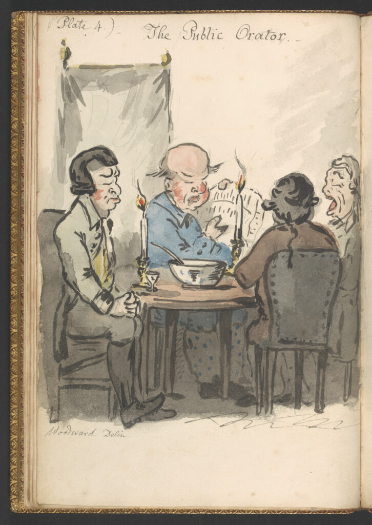
Figure 5. George Moutard Woodward, “The Public Orator,” plate 4 of “Coffee-House Characters, or Hints to the Readers of Newspapers Exemplified in Eight Characteristic Designs with Letter Press Elucidations to Each Plate” (ca. 1808). Watercolor on paper, 27 × 19 cm. Courtesy of the Yale Center for British Art (Paul Mellon Collection, B1977.14.9619(e)). Click on image to view in high resolution.
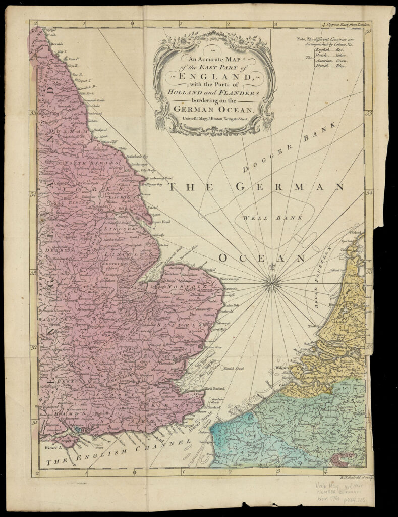
The heart of public debate in England was the coffee house, first introduced during the Civil War in the 1640s, and proliferating rapidly thereafter (figs. 4 and 5 above). Political events stimulated a demand for news and opinion, which was met by a printing trade newly released from government restrictions. Coffee houses offered a place where, in theory, rich and poor, men and women, learned and unlearned could sit at the same tables and engage in the critical discussion of the affairs of the day, affairs that were properly the remit of the courts. (The egalitarian sociability of the coffee house was in marked contrast to the persistence of class differences in England’s taverns and inns.) With Charles II’s restoration, the government recognized coffee houses to be inherently subversive of royal power and, in 1675, it tried unsuccessfully to close them down (Pincus 1995). Charles II was able to reimpose restrictions on the printing trades, although they proved unwieldy and did little to curtail the ever-growing market for printed materials; moreover, growing envy over the monopoly granted by the king to the Stationers led Parliament to allow the restrictions to lapse in 1695 (Astbury 1978; Gibbs 1992, esp. 233–37; Schwoerer 1992). While some legal constraints remained in force—notably paper taxes, the confused issue of copyright, libel, and continued parliamentary privileges—the press rapidly expanded in London and the provinces. They produced a veritable flood of publications to assuage an increasingly voracious public appetite for information and criticism about all manner of things. Especially important in this regard was the eighteenth-century proliferation of newspapers and monthly periodicals that did much to promote the new forms of coffee house civility and the norms of cultural and political criticism (Brewer 1997, 125–97; Porter 2000, 72–95; also Gibbs 1992). The magazines, and even some of the newspapers, included many geographical maps to inform and engage the public (fig. 6 below) (Jolly 1990).
Figure 6. R. W. Seale, An Accurate Map of the East Part of England with the Parts of Holland and Flanders bordering on the German Ocean, from Universal Magazine 27 (November 1760). Copper engraving, with added modern color, 36 × 28 cm. Courtesy of the Osher Map Library and Smith Center for Cartographic Education, University of Southern Maine (OML Collections). Click on image to view in high resolution.
When Parliament allowed press restrictions to lapse in 1695, they did so without any reference to the “freedom of the press.” Instead, that principle grew out of the development and entrenchment of public debate. For critical debates to be truly rational and effective, the public needed to possess all relevant, or potentially relevant information; this in turn promoted a “principle of supervision” by which the emergent public claimed the right to investigate and to reform the workings of both private life and the state in order to protect and preserve “society” (Warner 1990, 41). Publicity on the workings of society was readily achieved through a substantial body of literature, exemplified by the new encyclopedias. At the same time, the state fought long and hard to prevent publicity of its workings. In particular, Parliament considered its proceedings to be privileged, so that publicly distributed periodicals had to be very careful in how they reported parliamentary debates; eventually, the privilege was effectively nullified by the press in 1771, but journalists were still not legally permitted into the visitors’ galleries in Parliament until 1803 (Thomas 1959; Brewer 1990, 221–49). Eventually the British public succeeded in acquiring political power with the 1832 Reform Act.
There were of course several limitations to the ability of people to participate in the public sphere. Coffee houses were generally respectable places for genteel women, much more so than taverns and inns, and some women did indeed frequent them, just as some women engaged in trade and read the newspapers (Pincus 1995; Jacob 1994; Eger et al. 2001). Nonetheless, tied as they were to the domestic sphere of the household economy and social reproduction, most women participated far less in public debate than men. By the end of the eighteenth century, women were being explicitly excluded from existing social institutions, leading them to create their own social institutions in the nineteenth century (Baker 1992; Goodman 1994). Even in the domestic sphere, however, women significantly contributed to public debate, in that they set the tone for civility and politeness, and they participated significantly in the critique of cultural affairs (Barker-Benfield 1992; also Walters 1997).
There was an economic cost to attending coffee houses. In principle, anyone who had a penny with which to buy coffee could sit and talk in a coffee house, but in practice one had to afford to be able to sit around talking rather than working and one had to afford a penny for coffee. One penny in 1750 is equivalent to £8–10 in 2020, much more than a large Starbucks coffee with all the trimmings. Furthermore, the public did not congregate solely in coffee houses to engage in critical debate. They also congregated in the socially exclusive forums of private clubs (which often met in taverns), museums, theaters, concert halls, assembly rooms, subscription libraries, art galleries, scientific societies, and “projecting societies” such as philanthropic organizations. These various sites, in which was often set the agenda for more general critical discussion, were all socially restricted in their membership. Face-to-face public debate thus excluded the lower, laboring classes.
There were limits as well to the social and geographical universality offered by print. In the first place, there were obviously limits to the ability to read printed texts. A number of studies give an approximate sense of steadily increasing rates of writing literacy in England: for adult men, 10% in 1500, 45% in 1714, 60% in about 1750; for adult women, 1%, 25%, and 40% respectively. Rates of reading literacy would have been higher for both men and women. Literacy rates would also be higher according to social standing, profession, and geography. Regardless of the uncertainties, it is plain that a substantial and significant proportion of the English population was excluded from participating in public debate because of their inability to read (Brewer 1997, 167-69). To this must be added economic limits on the acquisition of printed materials—which could be quite expensive—and geographical limits too, as books and pamphlets had to be shipped from a few publication centers to regional consumers. Even if books were affordable for provincial readers, they were not necessarily accessible (see, e.g., Elliott 2000, 83–86). Costs were mitigated to some degree, by the free provision of the latest newspapers and pamphlets in coffee houses, and by circulating libraries and book-buying clubs.
Finally, public debate, as it developed in England and elsewhere in western and northern Europe, relied on claims of impartiality and reason that promoted the status of the literate, middling sort even as it excluded the less- or un-educated laboring classes. The goal of public debate was always, it was claimed, to understand what was best for society as a whole. It entailed a “principle of negativity,” by which authors negated their own individuality in order to stand forth as generic, virtuous citizens of the public sphere (Warner 1990, 42–43). By setting aside social rank, public debate implicitly disregarded the concerns and preoccupations of the individual; public opinion was most emphatically not personal opinion. Informed in large part by the demand for lucidity in the writing of natural philosophy, as encouraged by the Royal Society, public debate was configured in the later seventeenth century as a “plain” style which was considered conducive to the unbiased presentation of facts. Linguistic ornamentation and excess fell out of favor to be replaced by a straightforward manner of expression (Shapin 1994; Shapiro 2000; see Broman 1998). Public debate was also beneficial because it generally improved both the state of knowledge (by exposing inadequate and incorrect ideas) and the moral capacity of its participants. As Samuel Johnson opined: “he that reads books of science, though without any desire fixed of improvement, will grow more knowing; he that entertains himself with moral or religious treatises, will imperceptibly advance in goodness” (quoted by Brewer 1997, 167). It was not for nothing that coffee houses were routinely described as penny universities or academies.
The claim to disinterest served a very practical purpose in the early years of the public sphere, when the government still imprisoned or physically punished those authors who were outspoken in their opposition to government policy. Yet such recrimination was inflicted only on those authors who lacked both sufficient rank in their own right and the interest of a sufficiently powerful protector to avoid punishment. Divisions in social, economic, and political status continued to pervade the production of works within the public sphere, no matter the claims made to the contrary. A few authors were directly patronized by royalty or nobility, and others sought preferment through the influence of well-placed supporters and protectors. Moreover, some participants in public debate were better able to position themselves than others: contemporaries held independently wealthy nobles and gentlemen to be more properly disinterested in their opinions than the “hack” authors who were known to write whatever their employers wanted from them. In general, authors fell into one of three categories: those who wrote for themselves; those who wrote for political patrons; and those who wrote under commission to book sellers, who eventually became the great patrons of all kinds of literature in the eighteenth century. This last group included a large number of professional “authors,” most notably Samuel Johnson. The book sellers themselves served as crucial middlemen, mediating between the interests of the public, the interests of courtly society, and their own commercial and intellectual interests (Korshin 1974; Brewer 1997, 460–61; e.g., Myers 1998).
Fundamentally, the eighteenth-century British public comprised those people—mostly white, mostly educated, mostly male, and at least moderately well-off—who had the leisure and wherewithal to participate in the public sphere. Public debate was very much an activity for the middling sort. By their participation, they could claim equality with those of superior social rank even as they maintained their social distance from the undifferentiated mob of the laboring classes. Participation within the public sphere was an inherently political act. Every act of criticism further validated the public’s right to participate in arenas once reserved to the private courts of government; every meeting of a restricted social forum ensured that this right was limited to a relative few. And engaging in public debate was the necessary avenue to social and political status; through the acquisition of learning and civility, one could erase humble origins and attain a secure position within the public and so society as a whole.
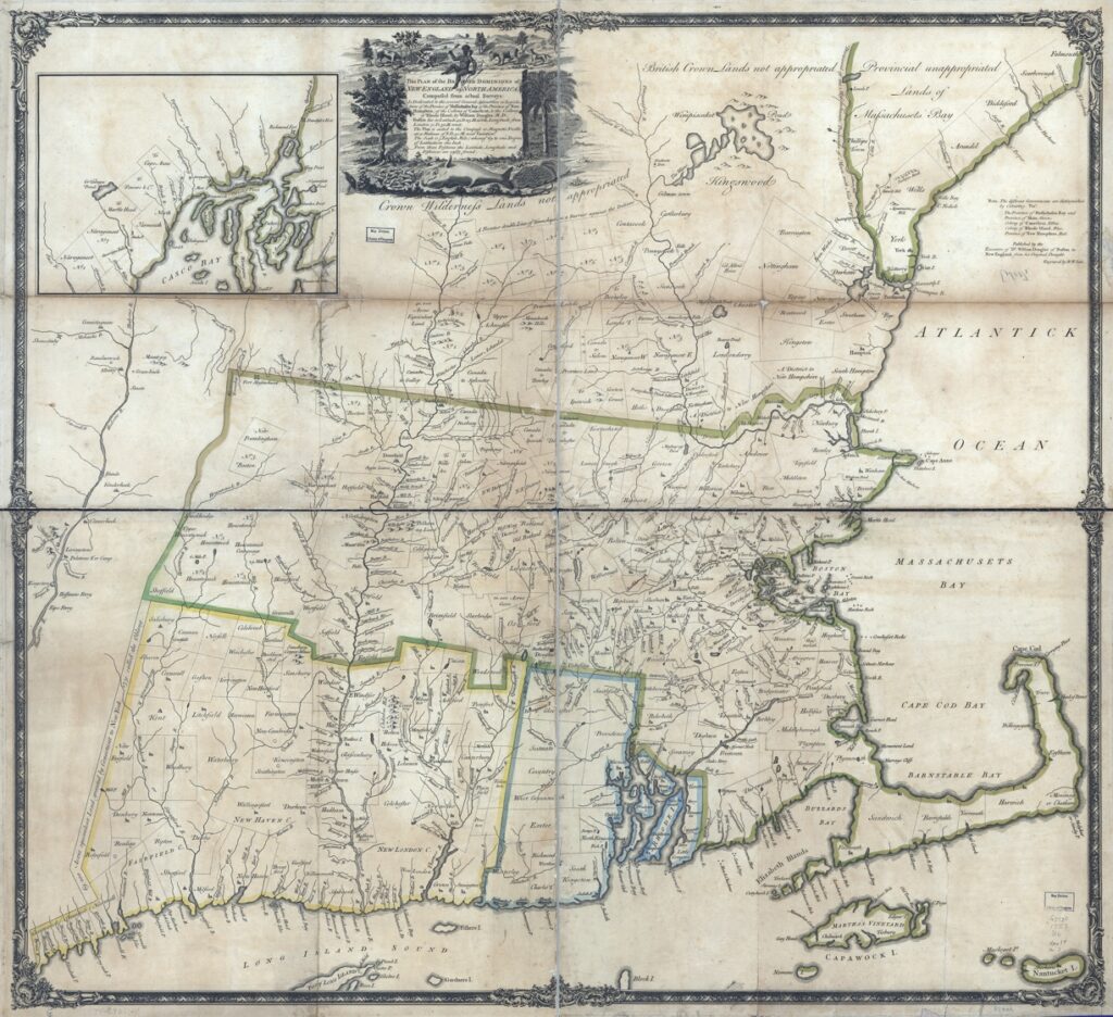
New England offers an alternative history of the rise of the public sphere. After 1715, coffee houses, clubs, tea tables, salons, and a burgeoning print industry offered a new sociability and civility that challenged and criticized the royal governors, colonial legislatures, and Puritan clergy who had long served as arbiters of colonial society and culture. In 1715, “public speech and writing” still comprised “the words of the authoritative few to the people,” but by the 1770s had come “to be understood by many…as the civic conversation of the people” (Grasso 1999, 4, original emphasis). A public emerged through a series of debates: over smallpox inoculation in 1721–1722, which centered on the rights of the clergy versus the medical professionals to pronounce on issues of public health; over colonial currency and the formation of “land banks,” which defined major political party lines; over the management and prosecution of colonial wars; and, especially after 1763, over the proper relationship of the colonies to Britain. Nonetheless, the smallness of the colonial economy impeded public debate. The colonial market could barely support the importation of new titles from London, let alone support the publication of a large number of titles in New England itself. Indeed, by the 1750s, the colonies had become something of a dumping ground for books remaindered from the metropolitan marketplace (fig. 7 below) (Botein 1983; Gilreath 1987; Raven 2002). Colonial New England’s emergent public accordingly comprised a small social and intellectual elite which sought to limit the persistent influence of the Puritan clergy even as it sought to stifle popular dissent (Hall 1996; Amory and Hall 2000).
Figure 7. William Douglass, This Plan of the British Dominions of New England in North America, Composed from Actual Surveys (London, [1755]). Left unfinished on Douglass’s death in 1752, this map was in 1755 engraved and printed in London for his nephew, Cornelius Douglass; it did not sell in London and impressions seem to have been dumped on the Boston market in late 1755 (Edney 2003). Hand-colored copper engraving in four sheets, 93 × 102 cm. Courtesy of the Geography and Map Division, Library of Congress (G3270 1753 .D6). Click on image to view in high resolution.
For Habermas, the eighteenth-century public sphere was “bourgeois” because it was the creation of the nascent middle class. Bearing in mind the manner in which the public sphere was bracketed and policed, it is more appropriate to argue that the public sphere created the bourgeoisie by the exclusion of those of lower social standing, radical politics, the wrong gender, criminality, and those who could not control their passions so as to be able to engage in disinterested deliberations (Hurd 2000, 77; Calhoun 2010, 312–13). In other words, participation in public debate shaped social organization, not the other way round.
Geographical Mapping and Public Debate in the Long Eighteenth Century
With these general points in mind, we can see how geographical practices contributed to the formation of critical, public debate and to the formation of the public (Mayhew 2019). Time and again, printed maps were used to publicize territorial disputes and to advance spatial concepts (e.g., Pedley 1998; Palsky 2017). Throughout Cartography in the European Enlightenment, Volume Four of The History of Cartography, printed geographical maps were tied up with emerging public spheres (Edney and Pedley 2019).
At a fundamental level, how could there be any rational and critical discussion of public affairs without a solid grounding in geographical knowledge? As a Scottish physician wrote to his daughter in 1739:
Whoever intends to read any History [or] even the common news Papers ought to know the Situation of the different Countries, the Nature of their Climates, the Distances of the most remarkable Places from each other and the other particulars which are to [be] learned from Globes and Maps. This knowledge is what I call geography. Without it one can not understand the different Claims and Interests of Potentates, the Causes of their different Complexions, of the gaining or losing of Battles, the difficulties or advantages of Armies or people in their Marches &c. A Months Application in this Study will make you very sensible how much People ignorant of it are blundering every day in common Conversation. …I hope you will be as much entertain’d hereafter with the Globes and Maps as you was the other Day when I shewed you the more general things upon your small Set being brought home. (Alexander Monro, “The Professor’s Daughter” (1739), quoted by Withers 2001, 125)
A firm grasp of geographical knowledge and practice was a fundamental requirement for anyone claiming any degree of education, gentility, or capacity for rational and disinterested thought (cf. the derisive comments by Senex 1721, 1). Geographical mapping was especially justified as a device to expand and train the mind, as a tool for applying knowledge to the practices of management and administration, and as a source of intellectual and aesthetic pleasure. For the autodidact, poet, and book seller Robert Dodsley, geography was the third arena of “polite learning” to be mastered by children, after reading and writing, and arithmetic and geometry, but before history, rhetoric and poetry, logic, ethics, laws, and manners (Dodsley 1748; see Solomon 1996, 127–30). Geography was “a Study both entertaining and useful to Ladies as well as to Gentlemen.… The Fair Sex may intermingle these Amusements with the operations of the Needle and the knowledge of a domestic life” (Harrington 1775, ix-x), although once out of the nursery most women would have encountered maps far less frequently than their brothers, husbands, and sons, who participated more fully in public debate. Geographical education flourished in seventeenth-century England and in the eighteenth century pervaded the lives of the middling sort, the gentry, and the aristocracy who participated in the public sphere. Geography became a staple not only of didactic texts but also of public lectures (a key site of sociability) and, in Scotland, also of university curricula (Withers 2001, 119–42).
Mastery of geographical knowledge was essential for anyone who sought to climb the social ladder. It was required for anyone who participated in England’s overseas trading networks. And, of course, geographical knowledge was a prerequisite for anyone seeking access to political power (Smith 1996). By consuming printed geographical maps, people participated in public debate as much as if they consumed political pamphlets, literary criticism, and theatrical performances. The consumption of printed geographical maps became a hallmark of membership within the socially privileged circles of the public, and was actively pursued by those seeking entry into those circles. At root, the consumption of printed geographical maps was not only a function of economics, it was also a political act that shaped social organization.
The late seventeenth and eighteenth centuries accordingly witnessed the same proliferation of cartographic forms within the marketplace as of other print products. Sure of a market, map sellers sought to reach out to less wealthy consumers and to insert cartographic imagery even into the domestic sphere of the middling sort, in the form of room screens (Reinhartz 2000), fans, playing cards, jig-saw puzzles, etc. It is no coincidence that commercial map production dramatically expanded in London during the last third of the seventeenth century, progressively supplanting the previous English dependence on Dutch map sellers, alongside the growth of the English economy. At the same time, the cost of geographical games and maps was high: single-sheet maps generally sold in London for six pennies in the eighteenth century (6 pennies in 1750 is £50–60 in 2020) while multi-sheet wall maps sold for at least ten shillings (or £1,000–1,200 in 2020) (Pedley 2005).
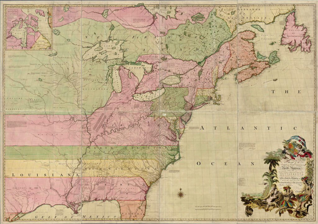
Figure 8. John Mitchell, A Map of the British and French Dominions of North America (London: Andrew Millar, 1755); this is the second variant in full publisher’s color. Hand-colored copper engraving in eight sheets, 136 × 195 cm. Courtesy of the Geography and Map Division, Library of Congress (G3300 1755 .M51). Click on image to view in high resolution.
One of the intriguing aspects of eighteenth-century British geography is how some individuals made just one or two maps, frequently of a substantial and complex nature, without any previous experience as “professional” geographers. Perhaps the most well-known of these individuals was John Mitchell, a Virginia-born doctor who was educated at the University of Edinburgh; after returning to England in 1746, Mitchell was commissioned by the president of the Board of Trade and Plantations to make a large wall map of the British and French colonies in North America (fig. 8 above) with which to argue against French territorial claims (Edney 2008). Another such figure was the Boston doctor William Douglass (see fig. 7). Such “amateurs” could make their maps because of the manner in which geographical practices were integral to the education and political activities of eighteenth-century gentlemen. Indeed, Mitchell’s map was copied in smaller formats, specifically to sustain public debate about the risk posed by the French to British colonies; the famous “Anti-Gallicans” map (fig. 9 below) was sold in a form designed to be easily carried and repeatedly opened without wearing out and tearing along the creases (Pedley 2007).
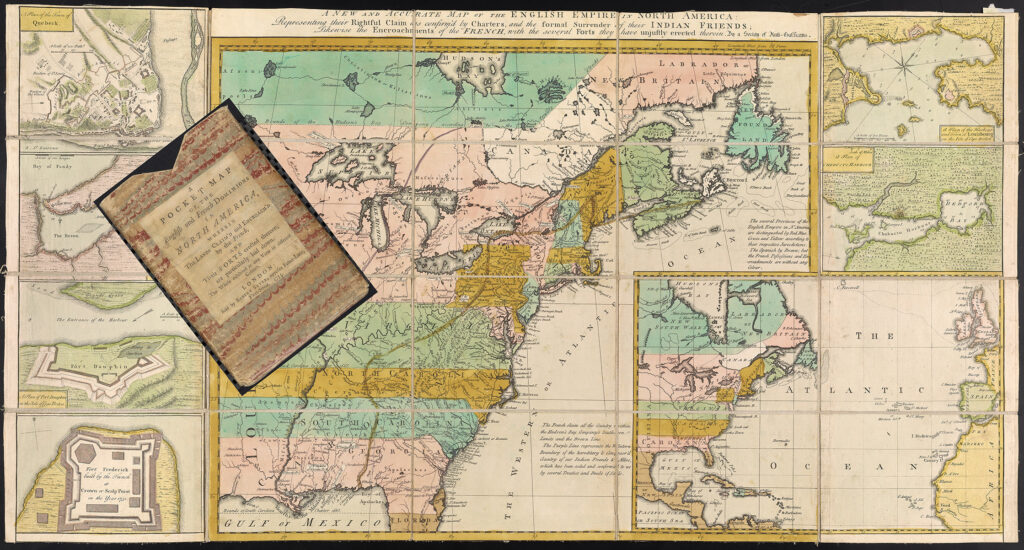
Figure 9. A New and Accurate Map of the English Empire in North America: Representing their Rightful Claim as confirmed by the Charters and the formal Surrender of their Indian Friends; Likewise the Encroachments of the French, with the several Forts they unjustly erected therein. By a Society of Anti-Gallicans (London: Herbert and Sayer, 1755). Hand-colored copper engraving, dissected onto cloth, 44 × 81 cm. Courtesy of the Osher Map Library and Smith Center for Cartographic Education, University of Southern Maine (Osher Collection). Click on image to view in high resolution; the carton is separately imaged here.
The ability of men like Mitchell and Douglass to make geographical maps highlights a crucial aspect of geography’s complete integration within public debate: the provision of geographical criticism. Just as public debate featured cultural criticism that defined the public’s artistic and literary tastes and styles, and that directed how the public should act in a civil manner, so it included a critique of geography that established the principles by which maps should properly be made. Geographers argued about the quality of their maps in public, issued detailed memoirs of how they constructed their maps, and reviewed new maps in monthly magazines; educated members of the public were expected to be able to distinguish well-done maps from “catchpennies” intended only to separate someone from their hard-earned wages. By laying out their work, geographers invited reasoned critique and correction, which could only further geographical knowledge (Bousquet-Bressolier 2019; Edney 2019, 485–88).
Geographical commentaries and specialized memoirs established the principle that geographical works needed to withstand the same process of critical evaluation as any other public text. Indeed, geographical authors invited their readers to engage with geographical works in a critical manner, to judge for themselves the merits of particular works and to compare maps for themselves. For example, in the preface to his Geography Rectified of 1680, Robert Morden listed the several prime meridians used in geographical maps, together with their longitudinal distances from the meridian of London, and urged his readers to use this information to reduce all geographical maps to a common geometry so as to be able to compare and evaluate them in an effective manner (Morden 1680, xi–xiv). While it is impossible to say how many members of the public actively engaged in such detailed geographical criticism, it is evident that a sizeable number of individuals were sufficiently interested to compare and evaluate geographical maps from different sources, and that some of these individuals actually made their own maps. Geographers functioned like any other contributor to the public sphere. Complicit in the reproduction of critical debate’s principles of authorial supervision and negativity, and of its universality and rationality, each geographer “passed his observations down to posterity in a medium available to every reader. He had an obligation to tell the truth and ran the ‘risk’ of ruining his reputation and of sinning against mankind when he made a mistake” (Novak 2001, 220–21).
Geographical mapping served as an empirical model of truth, certainty, and disinterest to which the public sphere aspired (Mousley 1991, 157). Benjamin Franklin, for example, turned to geography as the model of rational argument in his criticism of uncritical readings of newspapers in the mid-eighteenth century (Dean 2003). Certainly, geographical practice constituted one of the more obvious arenas of intellectual activity which were reformed by the rhetorical move late in the seventeenth century towards a “plain” style of representation that eschewed ornamentation and flourishes in order to allow the facts to speak for themselves, as it were (Varanka 1994). In the eighteenth century, the idea of the geographical map permeated public culture. Natural philosophers and encyclopedists likened their intellectual activities to the making of maps because they relied on essentially the same principles of rational thought and debate (Withers 2019; Britton 2021). Geographical mapping was, properly speaking, inherently disinterested.
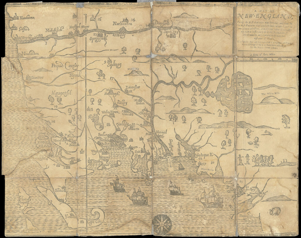
Figure 10. William Hubbard, A Map of New-England, Being the First that Ever Was Here Cut, and Done by the Best Pattern that Could Be Had, which Being in Some Places Defective, It Made the Other Less Exact: Yet Doth It Sufficiently Shew the Scituation of the Country, and Conveniently Well the Distance of Places, cut by John Foster, from Hubbard’s Narrative of the Troubles with the Indians (Hubbard 1677). Woodcut, 30 × 38 cm. Courtesy of the Osher Map Library and Smith Center for Cartographic Education, University of Southern Maine (Osher Collection). Click on image to view in high resolution.
English colonists in New England revealed the same basic concern for geography as a proper and integral component of a genteel education. In particular, the overseers of Harvard College prized greatly the globes given to the college in about 1660 by Sir Thomas Temple, and geography was taught at the college in the early eighteenth century before it was formally incorporated into the curriculum in 1734 (Anonymous 1925, 1:138, 198, 200, 3:301–22, 325–54, 455–56; Norton 1935, 366, 437n2). Moreover, several New Englanders actively engaged in geographical criticism. An early example is suggested by William Hubbard’s 1677 Map of New-England (fig. 10 above): the statement in the title that it was “done by the best Pattern that could be had” indicates that the map’s author could at least claim both an awareness of geographical maps of New England and the ability to evaluate them (Edney and Cimburek 2004). Again, in 1720, the Massachusetts attorney general Paul Dudley sent to the Royal Society in London a critique of John Senex’s 1710 map of North America, a critique based on the captivity narrative of Joseph Kellogg (Stearns 1936); we also know from the 1724 testimony of William Douglass, himself critically involved in geography, that Dudley also tried to make his own map of New England (Colden 1917–37, 1:167).
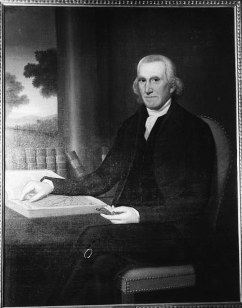
Figure 11. Ralph Earl, portrait of Sherman Boardman (1796). Oil on canvas, 119.5 × 91.5. Image courtesy of the National Portrait Gallery, Washington, D.C.; click on image to view in higher resolution. The painting itself is held by the New Milford Historical Society; Wikipedia has a color image.
The small size of the colonial economy, and so the relatively small number of colonists who aspired to genteel status, together with the weak and rather diffuse character of colonial New England’s public debate, meant that the local production, importation, and consumption of printed maps and other geographical texts was limited (for evidence of probate records, see Bosse 1999). Only by 1766 had the demand for maps printed locally or imported from London grown sufficiently to warrant the detailed listing of maps in the printed catalogs of Boston book sales. The continued rarity of geographical texts is suggested by Ralph Earl’s 1796 portrait of Sherman Boardman of New Milford, Connecticut (fig. 11 above). According to later family tradition, Boardman was “celebrated for his attainments in geography” and he posed in his portrait with a prized folio atlas. If this was the same atlas as the “Moll’s Geography” which was the only geographical work listed among Boardman’s possessions at the time of his death, then it would have been between fifty and eighty years old at the time of the portrait: too recent to be of antiquarian interest, old by contemporary European standards, but perhaps the best available to Boardman (Kornhauser 1991, no. 56; see Brückner 1999, fig. 1). Despite the limited extent of the colonial market for printed maps, that market was nonetheless defined by political concerns. In particular, those few geographical, topographical, and urban maps which were printed in Boston during the colonial period were all specific to the local public sphere. Colonial geographers did not publish maps of the Old World and its regions but focused only on North American subjects of relevance to New Englanders (Wheat and Brun 1978).
The Public Sphere and Geographical Mapping in the Nineteenth Century
Habermas’s “classic,” “bourgeois” public sphere of the eighteenth century—in which the middling sort came together to comment on and to regulate both state and private activities—did not fare well after 1800. The nineteenth-century public sphere is quite a different beast from the initial ideal, as Martin Brückner explores in Cartography in the Nineteenth Century, currently in preparation as Volume Five of The History of Cartography.
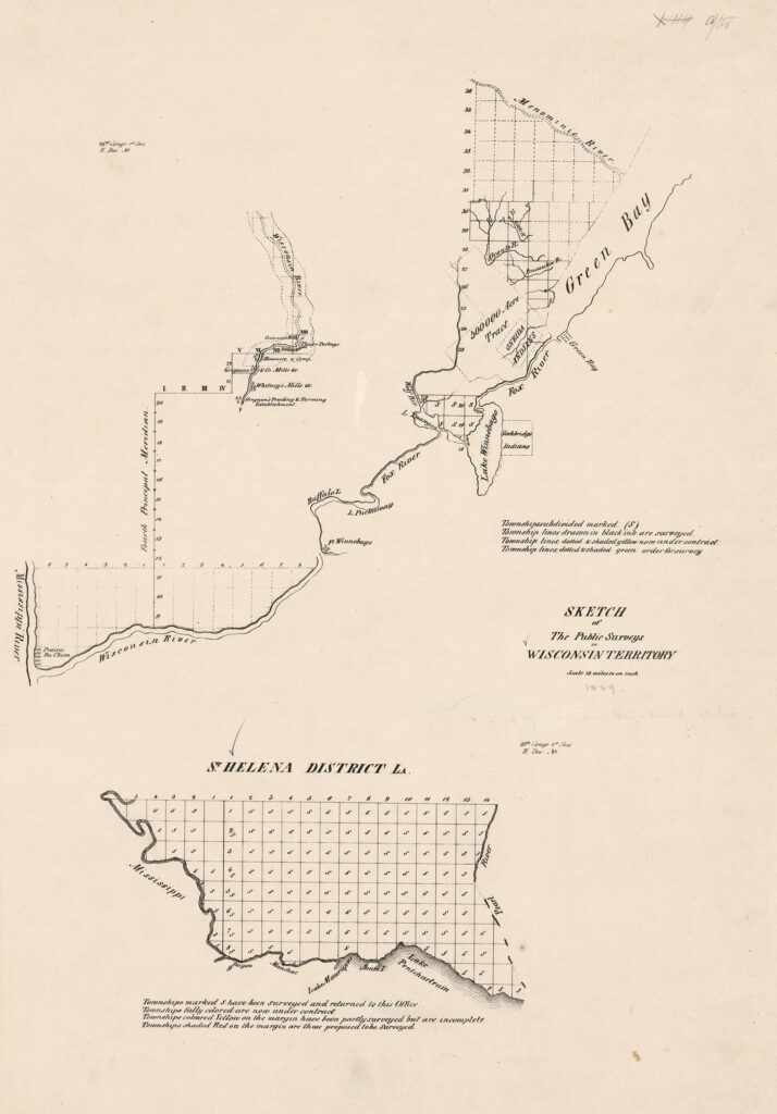
Figure 12. Sketch of the Public Surveys in Wisconsin Territory, Scale 18 Miles to an Inch (Washington, D.C., [26th Congress, 1st Session = December 1839–July 1840]), in A Collection of Maps, Charts, Drawings, Surveys, etc., Published from Time to Time, by Order of the Two Houses of Congress (Washington, 1843), unpaginated. An example of the kinds of maps of the surveys of the Public Domain prepared for official reports of the General Land Office. Of particular interest, in the upper map, are indications of early economic activity in the territory and the overlapping of the GLO surveys with Native American reservations. Lithograph, in a volume 68 cm tall. Courtesy of the Geography and Map Division, Library of Congress (G1200 U5 1843). Click on image to view in high resolution.
Some elements of the eighteenth-century formulations of public debate did continue and expand, especially the governmental acknowledgement of the necessity of publishing government reports and data. In Britain, for example, the volumes of Parliamentary Papers were vital to publishing basic data for the benefit of the public, and included many maps (McGechaen and Verner 1973); also, the Ordnance Survey was rather lax in enforcing its copyright in its topographical maps, allowing their use by a variety of commercial publishers. [n4] In the USA, both federal and state governments provided information about all sorts of mapping activities by executive agencies (fig. 12 above), information that was then incorporated into many commercial maps (fig. 13 below). Indeed, the federal US government has not asserted copyright over its publications, and users are free to reuse its data as long as they add some value, so that US official mapping activities are today the foundation of many commercial map products, including Google maps and GPSs.
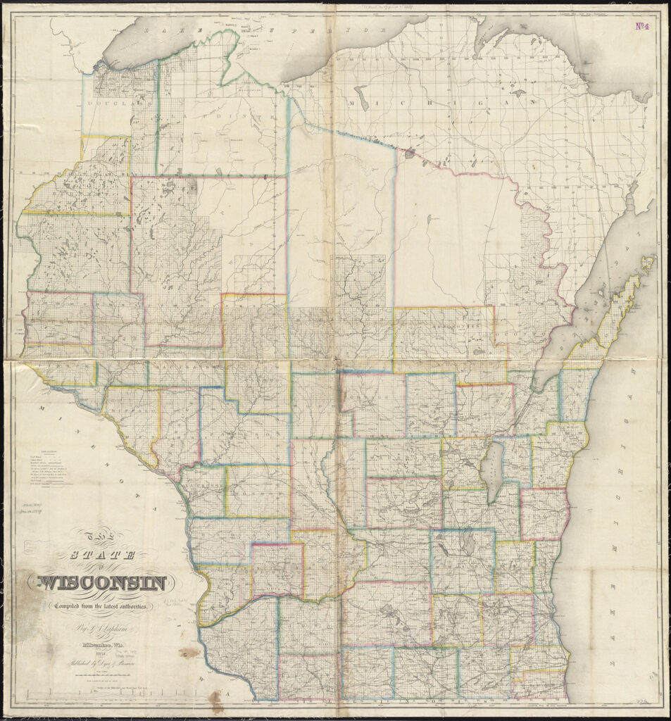
Figure 13. In making his large maps of Wisconsin, Increase A. Lapham drew extensively on published reports (fig. 12) and the surveyor’s manuscript journals of the surveys of the public domain by the federal General Land Office (Edmonds 1985; Bergland and Hayes 2014). Lapham, The State of Wisconsin Compiled from the Latest Authorities (Milwaukee, Wis.: Dyer & Pasmore, 1857). Hand-colored copper engraving, in four sheets, 131 × 124 cm. Courtesy of the Norman B. Leventhal Map Center, Boston Public Library (G4120 1857 .L37). Click on image to view in high resolution.
Even so, the nature of “the public” changed dramatically across the nineteenth century, and with it the nature of public debate and the public sphere. As the middling sort steadily attained political power, the lower classes began to assert their political competency and gained a significant voice in public political debate in the middle and later nineteenth century, necessarily completely transforming the nature of that debate. Madeleine Hurd has explained how, in urban settings, the public sphere began to spread out over three “linked forums: the public world of print, represented by newspapers; the world of public speech, sponsored by voluntary associations; and these associations’ demonstrations in public space.” Demonstrations, such as the marches of the Chartists in Britain (1838–1857), threatened the rhetorical universality of reasoned deliberation with what appeared to be mob-rule, while the forums of print and of the associations rapidly splintered the public along lines of class, political persuasion, and even intellectual interests (Hurd 2000, esp. 79).
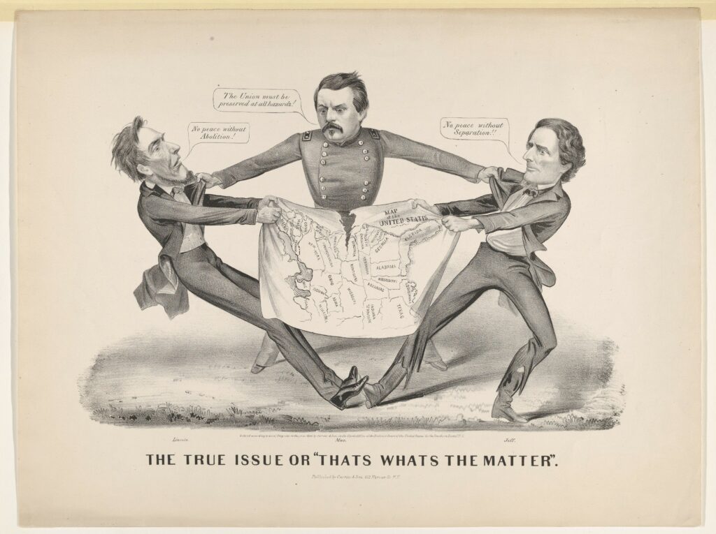
Figure 14. The True Issue or “Thats Whats the Matter” (New York: Currier and Ives, 1864). An early outline or logo map that stands in for a national territory, published during the 1864 US presidential campaign: Abraham Lincoln (“No peace without Abolition!”) and Jefferson Davis (“No peace without Separation!!”) are tearing up the country, while the Democratic candidate George McClellan seeks moderation (“The Union must be preserved at all hazards!”) (Grim and Block 2011, 58–59). Lithograph, 34 × 45 cm. Courtesy of the Metropolitan Museum of Art. Click on image to view in high resolution.
The fragmentation of the public was furthered by the rise of the nation-state as an ideal form of political organization, in the wake of Napoleon’s destruction of Europe’s anciens régimes of empires and kingdoms. Ideas of the nation relied on the construction of “imagined communities” through emotional appeals to nostalgia and invented traditions, appeals that fundamentally undercut the supposed disinterest of public debate. Geographical maps were crucial rhetorical elements, especially in the form of outline or logo maps of country outlines that readers might fill with their own nationalistic desires (fig. 14 above) (Anderson 1991, esp. 163–85). By the end of the century, logo maps were common elements of political cartoons, blending with other symbols, standing in not just for specific territories but also for nationalistic conceptions and imperialistic ambitions (fig. 15 below) (Heffernan 2009).
Figure 15. An imperialistic logo map. E. N. Blue, “Uncle Sam–’Guess I’ll Just Keep ’em,” Leslie’s Weekly (9 June 1898), cover. One of many newspaper and magazine cartoons promoting the US acquisition of imperial territories in the Caribbean (Puerto Rico) and Pacific (Philippines) (Ignacio et al. 2004, 18). Lithograph, 40.5 × 30 cm. Courtesy of the Wisconsin Historical Society.
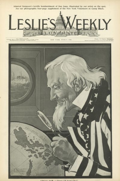
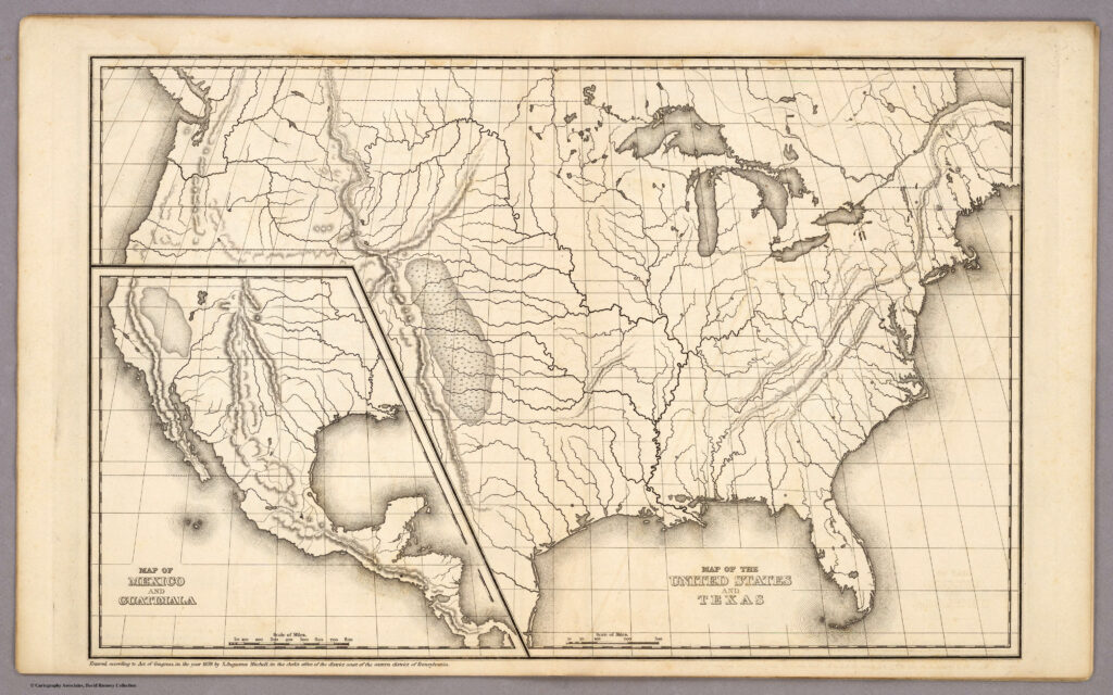
Figure 16. Map of the United States and Texas / Map of Mexico and Guatamala, in Samuel Augustus Mitchell, Mitchell’s Atlas of Outline Maps, Intended to Be Filled up by Pupils Studying Mitchell’s School Geography and Atlas (Philadelphia: Thomas, Cowperthwait, and Co., 1839). Copper engraving, 28 × 43. Courtesy of Cartographic Associates (0522.002). Click on image to view in high resolution.
Logo maps perhaps had their origin in the outline maps published in the educational texts prepared for compulsory primary education (fig. 16 above). Educational requirements drove literacy and political aspirations across all levels of society, aspirations that were fed by new and cheaper technologies of print reproduction. The new technologies included steel engraving, which permitted large print runs (as fig. 1), cerography or wax-engraving (fig. 17 below), and lithography. As print runs grew larger, the unit cost of books and maps plummeted (Brückner 2017). To make atlases easier to purchase, many were issued in parts (“fascicles”) so that customers might buy them over time rather than making a single large and unaffordable payment (as fig. 17).
Figure 17. Wisconsin, Southern Part 1845, in Sidney E. Morse and Samuel Breese, Morse’s North American Atlas (New York: Harper & Brothers, issued in fascicules between 1842 and 1845). Cerography, invented by Morse, used electrolysis to build up a relief printing surface on a metal plate and was widely used in the USA by commercial map publishers from the later nineteenth century into the twentieth (Woodward 1977). Cerographic print, in volume 45 cm tall. Courtesy of the Geography and Map Division, Library of Congress (G1105 .M6 1842). Click on image to view in high resolution.
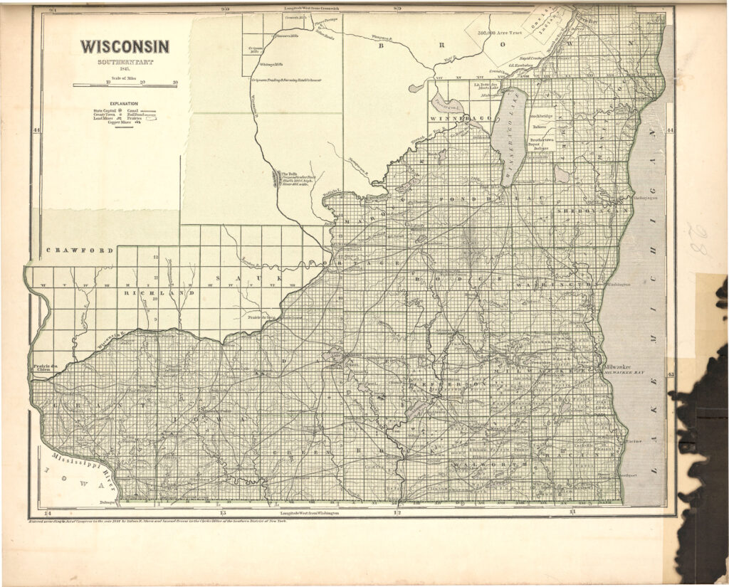
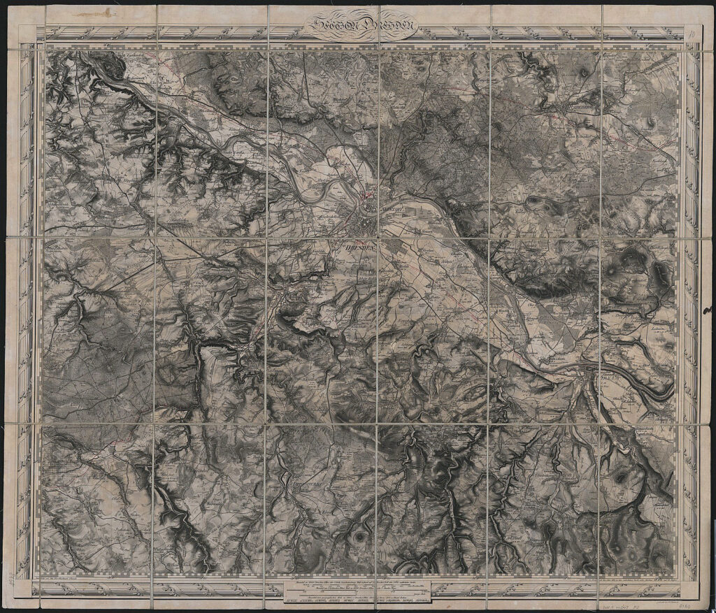
Figure 18. Topographischer Atlas des Königreichs Sachsen, 21 sheets at 1:57,600 (Dresden, 1836–1860), sheet 10, Section Dresden (1836). One sheet of many thousands prepared across Europe, its colonies, and North America during the nineteenth century, ostensibly for military purposes but printed for wider public consumption. Many have been imaged and geometrically stitched together by Arcanum, a truly fascinating website! Copper engraving, 60 × 72 cm. Courtesy of the Sächsische Landesbibliothek- Staats- und Universitätsbibliothek Dresden (SLUB/KS 8150). Click on image to view in high resolution.
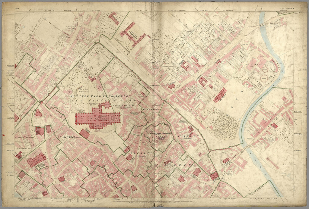
Figure 19. Ordnance Survey, York, 21 sheets at 1:1,056, surveyed 1850–51 (Southampton: Ordnance Survey, 1852), sheet 9. One sheet of just one of the approximately 4,000 cities and towns mapped in England and Wales at this huge scale to aid in the management of all the problems of industrializing cities (sewage, water supply, zoning, transportation systems, etc.) (Oliver 2014). These and other OS maps can be explored at the National Library of Scotland. Hand-colored, photozincograph, 63 × 92 cm. Courtesy of Cartographic Associates (6740.009). Click on image to view in high resolution.
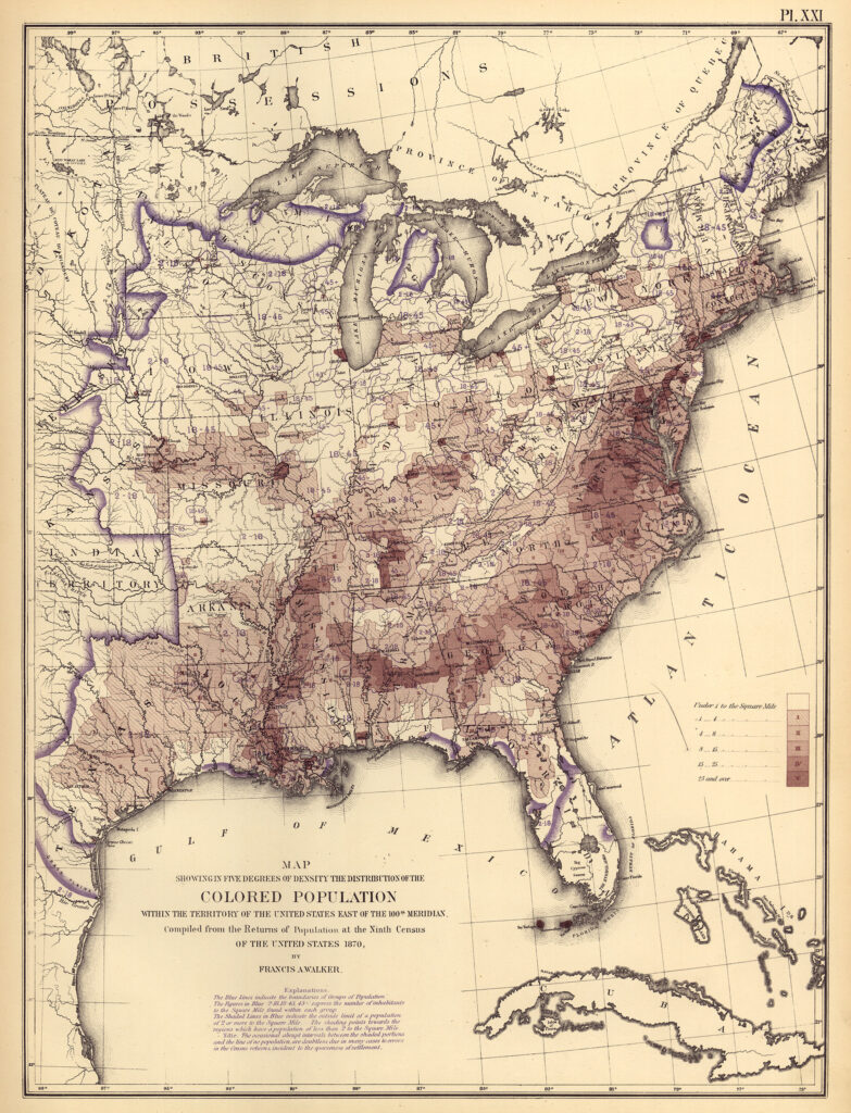
Figure 20. Francis Amasa Walker, Map Showing in Five Degrees of Density the Distribution of the Colored Population, in Statistical Atlas of the United States Based on the Results of the Ninth Census 1870 (Washington, D.C., 1874), pl. 21. Walker’s atlas was the first thematic mapping of a US Census, giving the US population information about the spatial characteristics of the country’s physical, social, and cultural environments. Color lithograph, 56 x 24 cm. Courtesy of the Library of Congress, Geography and Maps Division (G1201.G1 U53 1874). Click on image to view in high resolution.
The middle-ground of the public sphere was further eroded by the expansion of the two realms that it supposedly regulated, the state and private life. The apparatus of the state grew extensively, especially in Europe, as governments sought to regulate their burgeoning economies and the wholesale reorganization of urban and rural life with the application of new technologies; governments began to undertake cartographic and statistical surveys of their territories (fig. 18 above), cities (fig. 19 above), and populations (fig. 20 above), which they used to organize and structure private life directly (figs. 21, 22 below). At the same time, many of the small businesses run by individuals in the early modern era were reconfigured as large and ever more impersonal corporations. Such big businesses dealt directly with government regulators, bypassing the public sphere and becoming increasingly immune to public opinion (Calhoun 2015, 615). Moreover, the new systems aligned with the Second Great Awakening in Christian fervor, with the more systematic exclusion of women from the public sphere; women remained essential to the ability of men to function in public, but their work was obscured. Some middle- and upper-class women established their own organizations, notably in the fight for the abolition of slavery and for female suffrage (fig. 23 below), and thereby contributed to public debate, with maps (Dando 2017). In the twentieth century, the state became the dominant element of society, certainly according to fascistic and communistic ideologies, eclipsing the public altogether.
Figure 21. U.S. Post Office, Post Route Map of the States of New Hampshire, Vermont, Massachusetts, Rhode Island, Connecticut and Parts of New York and Maine Showing Post Offices with the Intermediate Distances and Mail Routes in Operation on the 1st of December 1884 (Washington, D.C. 1884). The US Post Office produced many maps of its routes, starting with Abraham Bradley’s 1792 map (Caldwell and Buehler 2010); this map is one of a set of 46 maps, each dissected and mounted on cloth (as fig. 9), that systematically covered the entire USA. The Post Office was highly important in gluing together the expanding nation (Blevins 2021). Colored lithograph, dissected onto cloth, 77.5 × 99 cm, folded to 21 × 13 cm. Courtesy of the Osher Map Library and Smith Center for Cartographic Education, University of Southern Maine (Osher Collection). Click on image to view in high resolution.
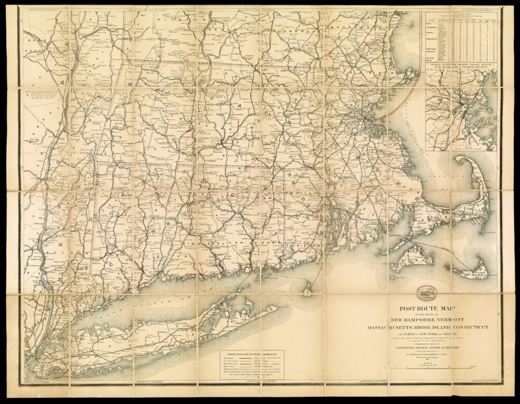
Figure 22. Alexander Hay Ritchie, after Francis Bicknell Carpenter, The First Reading of the Emancipation Proclamation before the Cabinet (New York, 1864). Carpenter’s original painting, completed in 1864, hangs in the US Senate. A map of the African-American population, printed by the US Coast Survey from US census data, can be seen at lower right; Lincoln later had to return to Carpenter’s studio to retrieve the map. This map, which Lincoln hung up in the White House, demonstrated the sheer number of slaves in the USA in 1860 and persuaded Lincoln of the need to emancipate them (Schulten 2010). Copper engraving, 52.5 × 82 cm. Courtesy of the Library of Congress, Prints and Photographs Division. Click on image to view in high resolution.
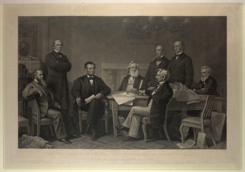
Figure 23. Present Suffrage Status (Richmond: Equal Suffrage League of Virginia, 1913). Broadsheet, 27 × 19 cm. Courtesy of the Osher Map Library and Smith Center for Cartographic Education, University of Southern Maine (OML Collection). Click on image to view in high resolution.
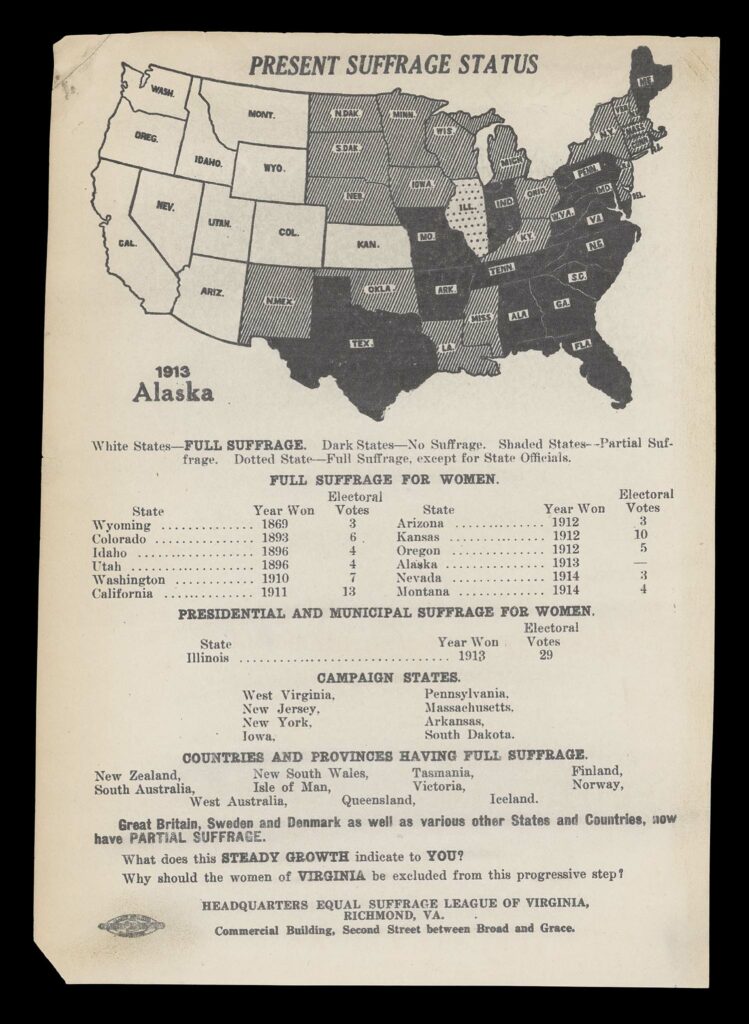
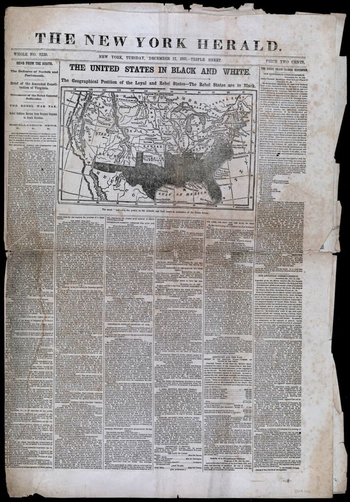
Figure 24. “The United States in Black and White,” New York Herald (17 December 1861), distinguishing between the “loyal” and “rebel” states; the latter being shown in black, with stars marking sites still in Union hands. This map laid out the basic geography of the Union versus the Confederacy during the tumultuous start of the war; the title played with the nature of public debate, laying out the facts in black ink on white, even as it referred to the primary reason for the Civil War: the ownership of African Americans in chattel slavery. Courtesy of the Osher Map Library and Smith Center for Cartographic Education, University of Southern Maine (OML Collections). Click on image to view in high resolution.
The nineteenth-century public sphere was accordingly characterized by growth and fragmentation. The steady growth in the number of voluntary associations increased the number of people participating in public activities and simultaneously fragmented perspectives on the affairs of the day. Newspaper maps were especially important in times of war and political change. During the US Civil War, for example, the northern press was especially active in using maps to communicate and commentate on battles and campaigns; some were collected in scrap books (Bosse 1993a; Bosse 1993b). Maps were used to explain the war (fig. 24 above) and to urge the Union to keep fighting (fig. 25 below).
Figure 25. How the War Commenced, and How Near It Is Ended (New York: National Union Executive Committee, [1864?]). As the US Civil War dragged on, many in the Union grew disenchanted with its human and economic toll and called for an end to hostilities. To counteract this anti-war sentiment, a specially formed political action committee published this broadsheet, seeking to remind Northerners of the moral principles behind the preservation of the Union. The broadsheet notes that the shaded areas constitute the slave states, and it seems that the difference between shaded and black regions is simply one of degree of slave-ownership across the Confederacy. Broadsheet, 48 × 31 cm. Courtesy of the Library of Congress, Geography and Maps Division (G3861.S5 1864 .N3). Click on image to view in high resolution.
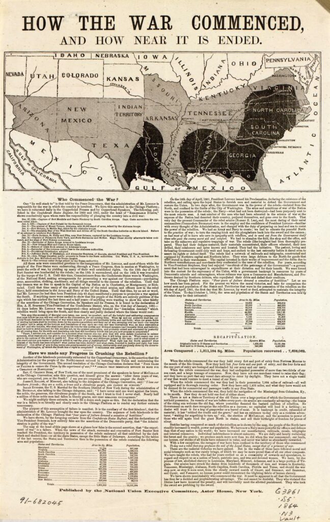
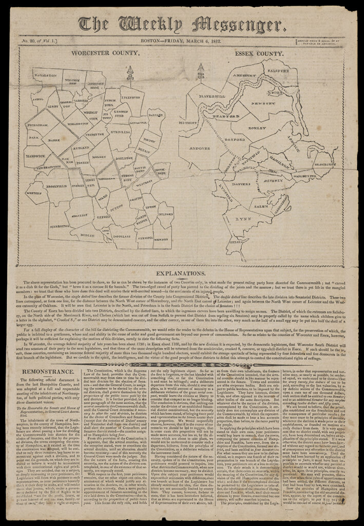
Figure 26. Worcester County / Essex County, in The Weekly Messenger (Boston, 6 March 1812); the dashed lines indicated the electoral districts created by Governor Elbridge Gerry to benefit the Republicans. Woodcut, 21 × 31 cm. Courtesy of the Osher Map Library and Smith Center for Cartographic Education, University of Southern Maine (OML Collections). Click on image to view in high resolution.
Yet even in the eighteenth century, newspapers had encouraged gossip and lazy and uncritical reading habits (Dean 2003), and in the nineteenth century they actively twisted the rhetoric of disinterested debate to party political ends. When the Democratic-Republican governor of Massachusetts, Elbridge Gerry, reconfigured voting districts to ensure a Republican majority in the state house, a Federalist newspaper used a map to demonstrate the naked interest behind the move (fig. 26 above). The rhetorical power of such plain speech was soon eclipsed, however, when Elkanah Tisdale turned the district of “Essex South” into a monster, which he called “the Gerry-mander” (fig. 27 below). The monster—and the term—stuck. For the most part, however, geographical maps in newspapers and magazines stayed graphically conventional, and seemingly disinterested, even as they supported highly interested arguments (fig. 28 below).
Figure 27. Natural and Political History of the Gerry-Mander, in Two Chapters, an 1820 reprint of the Boston Gazette’s original images and text (27 March 1812). The name “Gerry-mander” is explained by a quote from Jonathan Swift, “Now I appeal to each bye-stander, If this is not a Salamander.” Other newspapers mapped the salamander onto the Essex county, to make clear the unnatural shape of the new political district. Woodcut and letterpress broadsheet, 56 × 47 cm. Courtesy of the Norman B. Leventhal Map Center, Boston Public Library (G3763.E7F7 1820 .N38). Click on image to view in high resolution.
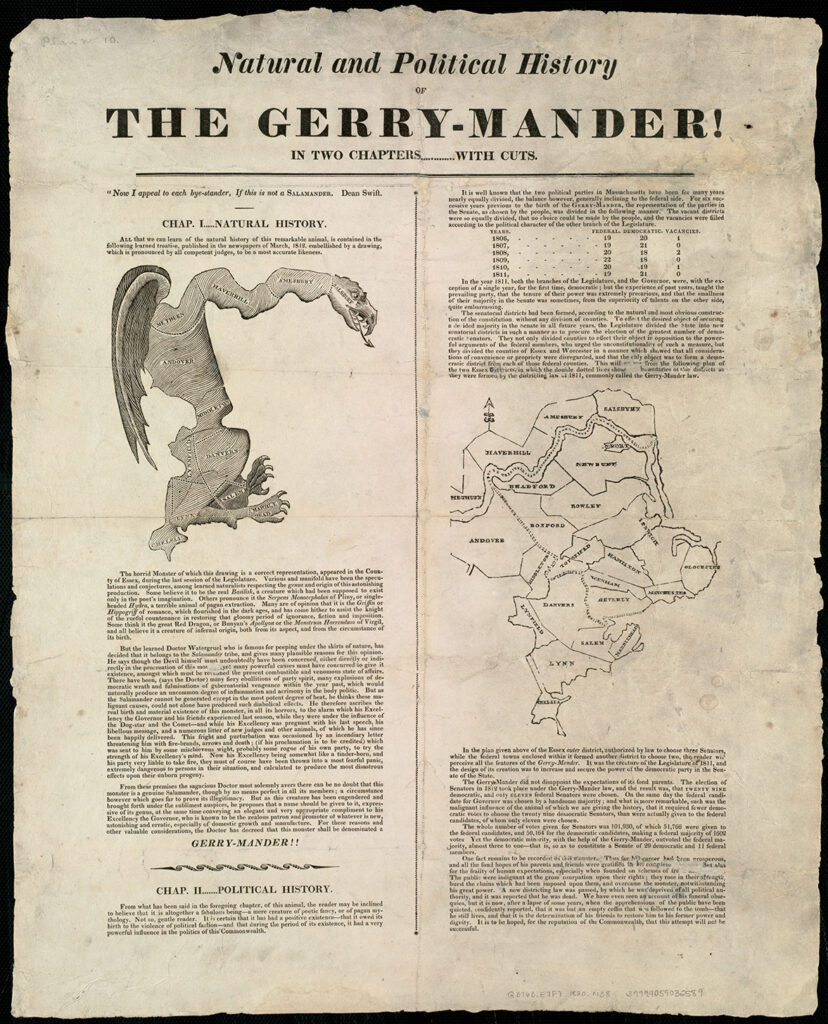
Figure 28. Walter Crane, Imperial Federation,–Map of the World Showing the Extent of the British Empire in 1886, insert to accompany J. C. R. Colomb, “Imperial Federation,” The Graphic 34, no. 869 (1886): 90–94. This now famous map celebrated the growth of British global power, its far-flung pink territories contrasted with the limited pink areas on the inset showing the situation a century earlier, flanked and supported by art nouveau depictions of the myriad peoples of the empire. Colomb, a member of parliament, was part of a movement that sought to reform the political structures of the empire to ensure that it continued to flourish and that it would benefit all its member populations, so that it would not disintegrate in short order. The artist, an ardent socialist, extended this power-sharing agenda to all labor, as the essential force by which Atlas sustained the world (Biltcliffe 2005; Driver 2010). Color lithograph, 58 × 77 cm. Courtesy of Cartography Associates (8238.000). Click on image to view in high resolution.
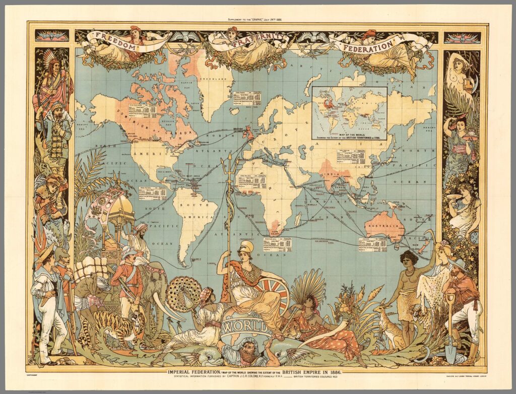
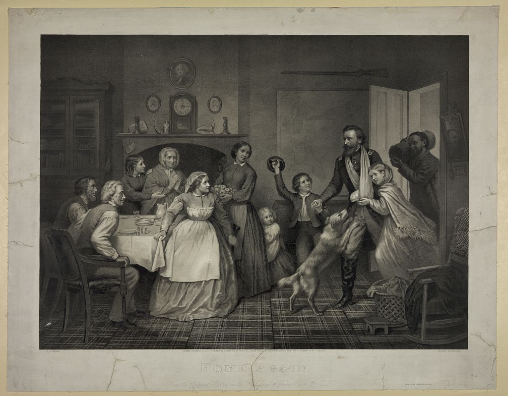
Figure 29. Trevor McClurg, Home Again, lith. Dominique C. Fabronius (New York: Endicott & Co., 1866). This mawkish view of the return of a wounded Union officer, at the end of the Civil War, shows a map displayed in the home’s front parlor. The map itself shows the eastern United States; Florida is noticeable. Lithograph. Courtesy of the Library of Congress, Prints and Photographs Division. Click on image to view in high resolution.
Maps proliferated as a fundamental form of information for all with an interest in public affairs. They provided a framework for groups of people to understand emergent nations and empires and to come together as citizens of something more than their particular locale. Wall maps became a common form of decoration in the houses of the middle classes, enabled by the spread of large, suburban domestic architecture engendered by the introduction of trolley cars (Warner 1962). They were placed in the public-facing front parlors, halls, and offices (fig. 29 above) (Brückner 2017). But, as with the broad character of the nineteenth-century public, the display of maps was not only informational, but served as a marker of communal identity, whether of the USA (as fig. 29), a state, a county (fig. 30 below), or a town or city (fig. 31 below).
Figure 30. E. M. Harney, Map of Winnebago County, Wisconsin, 1873. Officially published by Harney in Winnegon, Wis., for local consumption, the map was actually produced and printed in Milwaukee by J. N. Knauber & Co. (see Conzen 1984). Lithograph in 2 sheets, 138 × 128 cm. Courtesy of the Library of Congress, Geography and Maps Division (G4123.W8G46 1873 .H3). Click on image to view in high resolution.
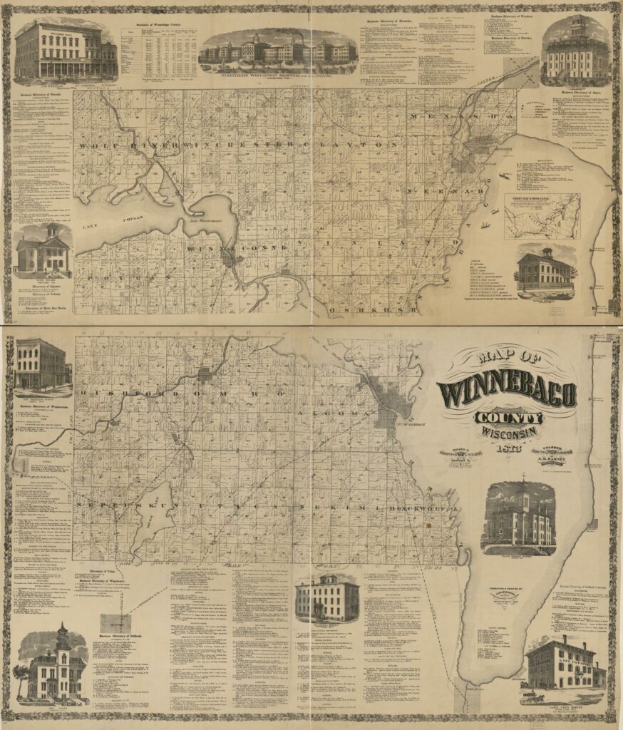
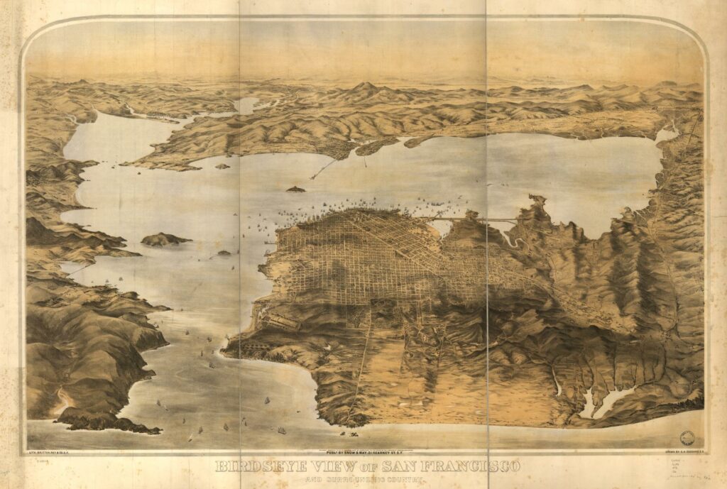
Figure 31. G. H. Goddard, Birdseye View of San Francisco and Surrounding Country (San Francisco: Snow & May, 1876). One of innumerable views of US urban places, from the smallest to the largest, produced in the later nineteenth century; while prepared in a few printing centers, they were sold to the inhabitants for display as a marker of civic pride (Reps 1984). Lithograph, 76 × 120 cm. Courtesy of the Library of Congress, Geography and Maps Division (G4364.S5A3 1876 .G6). Click on image to view in high resolution.
Maps, the Public, and the Study of Map History
The difference in public speech between the early modern and modern eras is shown by how, after 1800, geographical maps ceased to exemplify disinterested and reasoned debate, even as they continued to be taken as truthful statements about the world and its regions. Unmoored, the truth of maps could be turned to multiple ends, not only to those of critical debate but also to those of particular groups of people who shared party affiliations. The public sphere fragmented in the nineteenth century into many social communities. Consuming printed works, including maps, was a means of participating in, and creating, those communities.
This is the lesson of identifying and tracing the history of “the public sphere.” Setting aside the cavil that, because the universality of public debate was always a fiction, the public sphere per se has never truly existed, it is clear that studying how different groups of people engaged in public debate demonstrates how social structures are created by people doing things. Doing things like reading maps, as much as reading pamphlets or attending sociable meetings. It is not enough to say that map reading is a social phenomenon, but we must rather say that through map reading people claim a place within certain social groups. Map reading is one of the ways in which social relations are created (see Latour 2005).
This realization was an inspiration for David Woodward and Brian Harley when they worked to advance the study of map history by exploring how maps of all sorts work as cultural documents and social instruments. They did not refer to the “public sphere” in their essays; after all, the idea postdates, in Anglophone scholarship, their work in establishing The History of Cartography. Nor did they express their understanding of early maps in the way that I have done here. But they were each driven by a commitment to move beyond the awareness that maps are social and cultural devices and to reveal how maps work to shape human cultures and societies. I could write this account of maps in the public sphere because of the intellectual foundations that they laid. It has been one of my goals in designing the later volumes of the History to structure them so that readers can easily trace how different societies function through producing and consuming many different kinds of maps.
Moreover, we have to understand that reading about and studying maps situates us within a particular social group. Of course, our group of lovers of map history cuts across many other social groupings, whether economic, political, national, provincial, and so on. One of the ways that our group is sustained is through The History of Cartography, through writing for it, through reading it, and also through supporting it. Large or small, gifts to the History contribute to maintaining the intellectual community; supporters are as much a part of that community as any writers and readers. I therefore ask that you make a donation to support my skilled and expert staff as they complete the final volume in the series (Cartography in the Nineteenth Century, under the editorial direction of Roger Kain) and to support the social and intellectual community of map history lovers. Thank you.
Matthew Edney
Notes
n1. For example, Habermas (1989 [1962]) thought that political debate emerged from new literary debate in the early 1700s, whereas it is now clear that political debate came first in the seventeenth century. Other works dealing with the historical formation of the public sphere which I have found particularly useful are: Warner (1990); Goodman (1994); Pincus (1995); Shields (1997); Brewer (1997); Broman (1998); Zaret (2000); Melton (2001); Hunt et al. (2010); Cowan (2013).
n2. Translated and emphasis added by Goffart (2003, 1), who actually used a transcription from a 1572 French-language edition transcribed by Hofmann (2000, 99n6); I checked Goffart’s translation with the 1570 Latin.
n3. Note that the Habermasian “public” is not the same as that formulated by feminist scholars in distinction to “private”; feminist scholars formulated their own understanding of the public sphere of men engaged in productive labor in opposition to the highly constrained private sphere of women engaged in domestic, reproductive labor, such that they have used “public” to refer to three social phenomena that are more precisely delineated in Habermas’s scheme, specifically (1) the state, (2) the official, state-regulated economy, and (3) the arena of public debate, or the Habermasian public sphere per se (Fraser 1992, 110).
n4. I base this statement on Isabella Alexander’s presentation, “Good Maps, Cheap Maps, Copied Maps: Copyright and the Ordnance Survey in the 19th Century,” to the International Conference on the History of Cartography, Bucharest, 7 July 2022.
Works Cited
Adams, George. 1766. A Treatise Describing and Explaining the Construction and Use of New Celestial and Terrestrial Globes. London.
Amory, Hugh, and David D. Hall, eds. 2000. The Colonial Book in the Atlantic World. Vol. 1 of A History of the Book in America. Cambridge: Cambridge University Press for the American Antiquarian Society.
Anderson, Benedict. 1991. Imagined Communities: Reflections on the Origin and Spread of Nationalism. 2nd (revised) ed. London: Verso.
Anonymous. 1925–75. Harvard College Records. Publications of the Colonial Society of Massachusetts, 15–16, 31, 49–50. 5 vols. Boston: Colonial Society of Massachusetts.
Astbury, Raymond. 1978. “The Renewal of the Licensing Act in 1693 and its Lapse in 1695.” Library 5th ser. 33: 296–321.
Baker, Keith Michael. 1992. “Defining the Public Sphere in Eighteenth-Century France: Variations on a Theme by Habermas.” In Calhoun (1992, 181–211).
Barker-Benfield, G. J. 1992. The Culture of Sensibility: Sex and Society in Eighteenth-Century Britain. Chicago: University of Chicago Press.
Baynton-Williams, Ashley. 2022. “John Speed: A Prospect of the Most Famous Parts of the World.” MapForum. 10 February 2022. https://mapforum.com/2022/02/10/john-speed-a-prospect-of-the-most-famous-parts-of-the-world/.
Bergland, Martha, and Paul G. Hayes. 2014. Studying Wisconsin: The Life of Increase Lapham, Early Chronicler of Plants, Rocks, Rivers, Mounds, and All Things Wisconsin. Madison: Wisconsin Historical Society Press.
Biltcliffe, Pippa. 2005. “Walter Crane and the ‘Imperial Federation Map Showing the Extent of the British Empire’ (1886).” Imago Mundi 57, no. 1: 63–69.
Blevins, Cameron. 2021. Paper Trails: The US Post and the Making of the American West. New York: Oxford University Press.
Bosse, David. 1993a. Civil War Newspaper Maps: A Cartobibliography of the Northern Daily Press. Westport, Conn.: Greenwood Press.
———. 1993b. Civil War Newspaper Maps: A Historical Atlas. Baltimore: The Johns Hopkins University Press.
———. 1999. “The Boston Map Trade of the Eighteenth Century.” In Mapping Boston, ed. Alex Krieger, David Cobb, and Amy Turner, 36–55. Cambridge, Mass.: The MIT Press for the Muriel G. and Norman B. Leventhal Family Foundation.
Botein, Stephen. 1983. “The Anglo-American Book Trade before 1776: Personnel and Strategies.” In Printing and Society in Early America, ed. William L. Joyce, David D. Hall, Richard D. Brown, and John B. Hench, 48–82. Worcester, Mass.: American Antiquarian Society.
Bousquet-Bressolier, Catherine. 2019. “Memoirs, Cartographic.” In Edney and Pedley (2019, 933–36).
Brewer, John. 1990. The Sinews of Power: War, Money and the English State, 1688–1783. Cambridge, Mass.: Harvard University Press.
———. 1997. The Pleasures of the Imagination: English Culture in the Eighteenth Century. New York: Farrar Straus Giroux.
Britton, Jeanne M. 2021. “Graphic Constructions of Knowledge in Piranesi’s Maps and Diderot’s Encyclopédie.” Eighteenth Century Studies 54, no. 4: 957–78.
Broecke, Marcel P. R. van den, Peter van der Krogt, and Peter H. Meurer, eds. 1998. Abraham Ortelius and the First Atlas: Essays Commemorating the Quadricentennial of his Death, 1598–1998. ’t Goy-Houten, Netherlands: HES.
Broman, Thomas. 1998. “The Habermasian Public Sphere and ‘Science in the Enlightenment.’” History of Science 36: 123–49.
Brückner, Martin. 1999. “Lessons in Geography: Maps, Spellers, and Other Grammars of Nationalism in the Early Republic.” American Quarterly 51: 311–43.
———. 2017. The Social Life of Maps in America, 1750–1860. Chapel Hill: University of North Carolina Press for the Omohundro Institute for Early American History and Culture.
Caldwell, Larry, and Michael Buehler. 2010. “Picturing a Networked Nation: Abraham Bradley’s Landmark U.S. Postal Maps.” Portolan 77: 7–24.
Calhoun, Craig, ed. 1992. Habermas and the Public Sphere. Cambridge, Mass.: The MIT Press.
———. 2010. “The Public Sphere in the Field of Power.” Social Science History 34, no. 3: 301–35.
———. 2015. “Public Sphere: Nineteenth and Twentieth-Century History.” In International Encyclopedia of the Social & Behavioral Sciences, 615–19. 2nd ed. Leiden: Elsevier.
Colden, Cadwallader. 1917–37. The Letters and Papers of Cadwallader Colden. Collections of the New York Historical Society, 50–56 and 67–68. 9 vols. New York: New York Historical Society.
Conzen, Michael P. 1984. “The County Landownership Map in America: Its Commercial Development and Social Transformation, 1814–1939.” Imago Mundi 36: 9–31.
Cowan, Brian. 2013. “English Coffeehouses and French Salons: Rethinking Habermas, Gender and Sociability in Early Modern French and British Historiography.” In Making Space Public in Early Modern Europe: Performance, Geography, Privacy, ed. Angela Vanhaelen and Joseph P. Ward, 41–53. New York: Routledge.
Dando, Christina Elizabeth. 2017. Women and Cartography in the Progressive Era. London: Routledge.
Dean, Ann. 2003. “Benjamin Franklin, Writing by Hand: Manuscript, Print, and Political Imagination.” Journal for Early Modern Cultural Studies 4, no. 2: 89–113.
Defoe, Daniel. 1704. The Storm. London.
Dodsley, Robert, ed. 1748. The Preceptor: Containing a General Course of Education, wherein the First Principles of Polite Learning Are Laid Down. London: R. and J. Dodsley.
Driver, Felix. 2010. “In Search of The Imperial Map: Walter Crane and the Image of Empire.” History Workshop Journal 69, no. 1: 146–57.
Edmonds, Michael. 1985. “Increase A. Lapham and the Mapping of Wisconsin.” Wisconsin Magazine of History 68, no. 3: 162–87.
Edney, Matthew H. 2003. “New England Mapped: The Creation of a Colonial Territory.” In La cartografia europea tra primo Rinascimento e fine dell’Illuminismo, ed. Diogo Ramada Curto, Angelo Cattaneo, and André Ferrand de Almeida, 155–76. Florence: Leo S. Olschki Editore.
———. 2008. “John Mitchell’s Map of North America (1755): A Study of the Use and Publication of Official Maps in Eighteenth-Century Britain.” Imago Mundi 60, no. 1: 63–85.
———. 2019. “Geographical Mapping in the Enlightenment.” In Edney and Pedley (2019, 474–89).
Edney, Matthew H., and Susan Cimburek. 2004. “Telling the Traumatic Truth: William Hubbard’s Narrative of King Philip’s War and his ‘Map of New-England.’” William & Mary Quarterly 3rd ser. 61, no. 2: 317–48.
Edney, Matthew H., and Mary S. Pedley, eds. 2019. Cartography in the European Enlightenment. Vol. 4 of The History of Cartography. Chicago: University of Chicago Press.
Eger, Elizabeth, Charlotte Grant, Clíona Ó Gallchoir, and Penny Warburton. 2001. “Introduction: Women, Writing and Representation.” In Women, Writing and the Public Sphere, 1700–1830, ed. Elizabeth Eger, Charlotte Grant, Clíona Ó Gallchoir, and Penny Warburton, 1–23. Cambridge: Cambridge University Press.
Elliott, Paul A. 2000. “The Birth of Public Science in the English Provinces: Natural Philosophy in Derby, c. 1690–1760.” Annals of Science 57: 61–100.
Fraser, Nancy. 1992. “Rethinking the Public Sphere: A Contribution to the Critique of Actually Existing Democracy.” In Calhoun (1992, 109–42).
Gibbs, G. C. 1992. “Press and Public Opinion: Prospective.” In Liberty Secured? Britain Before and After 1688, ed. J. R. Jones, 231–64. Stanford, Calif.: Stanford University Press.
Gilreath, Janes. 1987. “American Book Distribution.” In Needs and Opportunities in the History of the Book: America, 1639–1876, ed. David D. Hall and John B. Hench, 103–85. Worcester, Mass.: American Antiquarian Society.
Goffart, Walter. 2003. Historical Atlases: The First Three Hundred Years, 1570–1870. Chicago: University of Chicago Press.
Goodman, Dena. 1994. The Republic of Letters: A Cultural History of the French Enlightenment. Ithaca, N.Y.: Cornell University Press.
Grasso, Christopher. 1999. A Speaking Aristocracy: Transforming Public Discourse in Eighteenth-Century Connecticut. Chapel Hill: University of North Carolina Press for the Omohundro Institute of Early American History and Culture, Williamsburg, Va.
Griffin, Dustin H. 2014. Authorship in the Long Eighteenth Century. Newark: University of Delaware Press.
Grim, Ronald E., and Debra Block. 2011. Torn in Two: 150th Anniversary of the Civil War. An Exhibition from the Collections of the Boston Public Library, May 12 to December 31, 2011. Boston: Norman B. Leventhal Map Center, Boston Public Library.
Habermas, Jürgen. 1989 [1962]. The Structural Transformation of the Public Sphere: An Inquiry into a Category of Bourgeois Society. Trans. Thomas Burger and Frederick Lawrence. Cambridge, Mass.: MIT Press. Originally published as Strukturwandel der Öffentlicheit (Darmstadt: Hermann Luchterhand Verlag, 1962).
Hall, David D. 1996. Cultures of Print: Essays in the History of the Book. Amherst: University of Massachusetts Press.
Harrington, S. 1775. A New Introduction to the Knowledge and Use of Maps; Rendered Easy and Familiar to any Capacity. 4th ed. London: S. Crowder and J. Walter.
Heffernan, Michael. 2009. “The Cartography of the Fourth Estate: Mapping the New Imperialism in British and French Newspapers, 1875–1925.” In The Imperial Map: Cartography and the Mastery of Empire, ed. James R. Akerman, 261–99. Chicago: University of Chicago Press.
Hofmann, Catherine. 2000. “La genèse de l’atlas historique en France (1630–1800): Pouvoir et limites de la carte comme ‘oeil de l’histoire.’” Bibliothèque de l’école des chartes 158, no. 1: 97–128.
Hondius, Jodocus. 1635. Historia Mundi: or Mercator’s Atlas. Trans. Wye Saltonstall. London: printed by T. Cotes for Michael Sparkes and Samuell Cartwright.
Hubbard, William. 1677. A Narrative of the Troubles with the Indians in New-England, from the first planting thereof in the year 1607, to this present year 1677. But chiefly of the late Troubles in the two last years, 1675 and 1676. To which is added a Discourse about the Warre with the Pequods In the year 1637. Boston: printed by John Foster.
Hunt, Lynn, Margaret C. Jacob, and Wijnand Mijnhardt. 2010. The Book that Changed Europe: Picart & Bernard’s Religious Ceremonies of the World. Cambridge, Mass.: Harvard University Press.
Hurd, Madeleine. 2000. “Class, Masculinity, Manners, and Mores: Public Space and Public Sphere in Nineteenth-Century Europe.” Social Science History 24, no. 1: 75–110.
Ignacio, Abe, Enrique de la Cruz, Jorge Emmanuel, and Helen Toribio. 2004. The Forbidden Book: The Philippine-American War in Political Cartoons. San Francisco: T’Boli.
Jacob, Margaret C. 1994. “The Mental Landscape of the Public Sphere: A European Perspective.” Eighteenth-Century Studies 28: 95–113.
Jolly, David C. 1990–91. Maps in British Periodicals. 2 vols. Brookline, Mass.: David C. Jolly.
Kornhauser, Elizabeth Mankin. 1991. Ralph Earl: The Face of the Young Republic. New Haven, Conn.: Yale University Press for the Wadsworth Athenaeum, Hartford.
Korshin, Paul J. 1974. “Types of Eighteenth-Century Literary Patronage.” Eighteenth-Century Studies 7, no. 4: 453–73.
Latour, Bruno. 2005. Reassembling the Social: An Introduction to Actor-Network-Theory. Oxford: Oxford University Press.
Mah, Harold. 2000. “Phantasies of the Public Sphere: Rethinking the Habermas of Historians.” Journal of Modern History 72: 153–82.
Mayhew, Robert J. 2019. “Public Sphere, Cartography and the.” In Edney and Pedley (2019, 1219–25).
McGechaen, Alexander, and Coolie Verner. 1973. Maps in the Parliamentary Papers by the Arrowsmiths: A Finding List. Map Collectors’ Circle, 88–89. 2 vols. London: Map Collectors’ Circle.
Melton, James Van Horn. 2001. The Rise of the Public in Enlightenment Europe. Cambridge: Cambridge University Press.
Morden, Robert. 1680. Geography Rectified: Or, A Description of the World. London: for Robert Morden and Thomas Cockeril.
Mousley, Andrew. 1991. “Self, State, and Seventeenth Century News.” Seventeenth Century 6: 149–68.
Myers, James P., Jr. 1998. “Bewitched by Maps: A Caveat.” Pennsylvania History 65, no. 2: 203–13.
Norton, Arthur O. 1935. “Harvard Text-Books and Reference Books of the Seventeenth Century.” In Transactions [of the Colonial Society of Massachusetts], 1930–1933, 361–438. Publications of the Colonial Society of Massachusetts, 28. Boston: Colonial Society of Massachusetts.
Novak, Maximillian E. 2001. Daniel Defoe: Master of Fictions. Oxford: Oxford University Press.
Oliver, Richard. 2014. The Ordnance Survey in the Nineteenth Century: Maps, Money and the Growth of Government. London: Charles Close Society.
Ortelius, Abraham. 1570. Theatrum orbis terrarum. Antwerp: Gielis van Diest.
Palsky, Gilles. 2017. “Une cartographie des lumières: La Nouvelle mappemonde dédiée au progrès de nos connaissances de Nicolas-Antoine Boullanger (1753).” Cartes et Géomatique 234: 81–90.
Pedley, Mary Sponberg. 1998. “Map Wars: The Role of Maps in the Nova Scotia/Acadia Boundary Disputes of 1750.” Imago Mundi 50: 96–104.
———. 2005. The Commerce of Cartography: Making and Marketing Maps in Eighteenth-Century France and England. Chicago: University of Chicago Press.
———. 2007. “A new and accurate map of the English Empire in North America by a Society of Anti-Gallicans (London, 1755).” In Mappæ Antiquæ: Liber Amicorum Günter Schilder. Vriendenboek ter gelegenheid van zijn 65te verjaardag, ed. Paula van Gestel-van het Schip et al., 449–58. ’t Goy-Houten, Neth.: HES & De Graaf.
Pincus, Steve. 1995. “‘Coffee politicians does create’: Coffeehouses and Restoration Political Culture.” Journal of Modern History 67: 807–34.
Porter, Roy. 2000. The Creation of the Modern World: The Untold Story of the British Enlightenment. New York: W. W. Norton.
Raven, James. 2002. London Booksellers and American Customers: Transatlantic Literary Community and the Charleston Library Society, 1748–1811. Columbia: University of South Carolina Press.
Reinhartz, Dennis. 2000. “Interior Geographies: Map Screens from the Age of Exploration, Expansion, and Trade.” Mercator’s World 5, no. 5: 32–35.
Reps, John W. 1984. Views and Viewmakers of Urban America: Lithographs of Towns and Cities in the United States and Canada, Notes on the Artists and Publishers, and a Union Catalog of their Work, 1825–1925. Columbia: University of Missouri Press.
Robbins, Bruce, ed. 1993. The Phantom Public Sphere. Minneapolis: University of Minnesota Press.
Schulten, Susan. 2010. “The Cartography of Slavery and the Authority of Statistics.” Civil War History 56, no. 1: 5–32.
Schwoerer, Lois G. 1992. “Liberty of the Press and Public Opinion.” In Liberty Secured? Britain Before and After 1688, ed. J. R. Jones, 199–230. Stanford, Calif.: Stanford University Press.
Senex, John. 1721. A New General Atlas, Containing a Geographical and Historical Account of All the Empires, Kingdoms, and other Dominions of the World. London: Daniel Browne, Thomas Taylor, John Darby, John Senex, William Taylor, Joseph Smith, Andrew Johnston, William Bray, Edward Symon.
Shapin, Steven. 1994. A Social History of Truth: Civility and Science in Seventeenth-Century England. Chicago: University of Chicago Press.
Shapiro, Barbara J. 2000. A Culture of Fact: England, 1550–1720. Ithaca, N.Y.: Cornell University Press.
Shields, David S. 1997. Civil Tongues & Polite Letters in British America. Chapel Hill: University of North Carolina Press for the Institute of Early American History and Culture.
Skelton, R. A. 1966. “Bibliographical Note.” In John Speed, A Prospect of the The Most Famous Parts of the World, London 1627, v–xv. Amsterdam: Theatrum Orbis Terrarum.
Smith, Jonathan M. 1996. “State Formation, Geography, and a Gentleman’s Education.” Geographical Review 86: 91–100.
Solomon, Harry M. 1996. The Rise of Robert Dodsley: Creating the New Age of Print. Carbondale: Southern Illinois University Press.
Speed, John. 1611. The Theatre of the Empire of Great Britaine: Presenting an Exact Geography of the Kingdomes of England, Scotland, Ireland, and the Iles Adioyning: With the Shires, Hundreds, Cities and Shire-townes, within the Kingdome of England, Divided and Described. London: John Sudbury and Georg Humble.
———. 1676. The Theatre of the Empire of Great-Britain, Presenting an Exact Geography of the Kingdom of England, Scotland, Ireland, and the Isles Adjoyning…Together with a Prospect of the Most Famous Parts of the World. Ed. Edward Phillips. London: Thomas Bassett and Richard Chiswell.
Stearns, Raymond Phineas. 1936. “Joseph Kellog’s Observations on Senex’s Map of North America (1710).” Mississippi Valley Historical Review 23: 345–54.
Thomas, P. D. G. 1959. “The Beginning of Parliamentary Reporting in Newspapers, 1768–1774.” English Historical Review 74: 623–36.
Varanka, Dalia. 1994. “Editorial and Design Principles in the Rise of the English World Atlases, 1606–1789.” Ph.D. dissertation. University of Wisconsin–Milwaukee.
Wallis, Helen M. 1978. “The Place of Globes in English Education, 1600–1800.” Der Globusfreund 25-27: 103–10.
———. 1980. “The Royal Map Collections of England.” Revista da Univsersidade de Coimbra 28: 461–68.
Walters, Alice N. 1997. “Conversation Pieces: Science and Politeness in Eighteenth-Century England.” History of Science 35: 121–54.
Warner, Michael. 1990. The Letters of the Republic: Publication and the Public Sphere in Eighteenth-Century America. Cambridge, Mass.: Harvard University Press.
Warner, Sam B., Jr. 1962. Streetcar Suburbs: The Process of Growth in Boston, 1870–1900. Cambridge, Mass.: Harvard University Press.
Wheat, James Clements, and Christian F. Brun. 1978. Maps and Charts Published in America before 1800: A Bibliography. Rev. ed. London: Holland Press.
Withers, Charles W. J. 2001. Geography, Science and National Identity: Scotland since 1520. Cambridge: Cambridge University Press.
———. 2019. “Encyclopedias.” In Edney and Pedley (2019, 379–83).
Woodward, David. 1977. The All-American Map: Wax-Engraving and its Influence on Cartography. Chicago: University of Chicago Press.
Zaret, David. 2000. Origins of Democratic Culture: Printing, Petitions, and the Public Sphere in Early-Modern England. Princeton, N.J.: Princeton University Press.