
Internationalism in Cartography
Below, project director Matthew Edney takes an in-depth look at the topic of international collaboration that we highlighted in our 2023 outreach letter.
Please consider contributing your support to the international effort that is the History of Cartography Project – click “Make A Gift” at right to donate online!
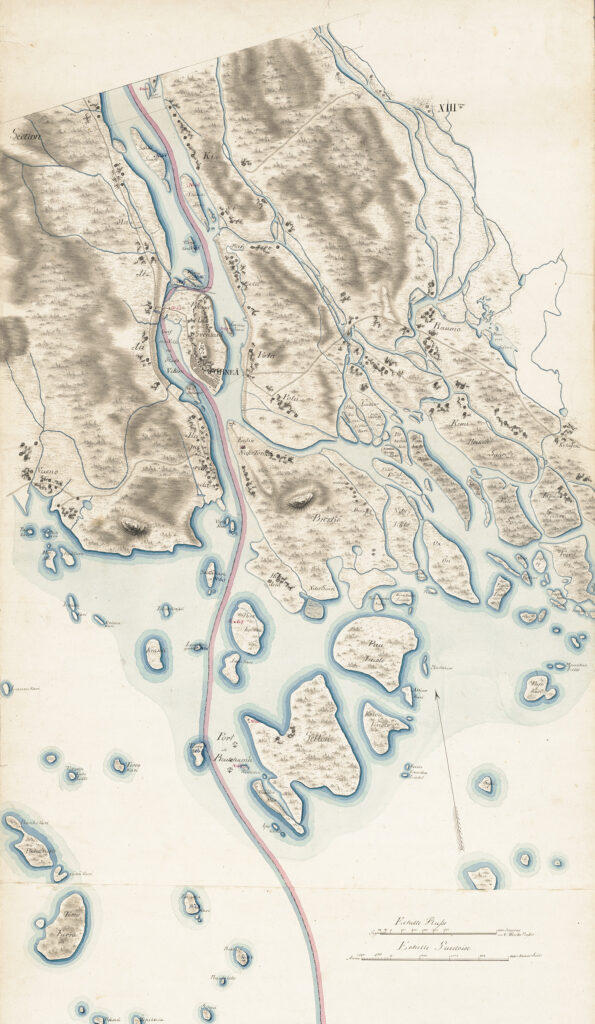
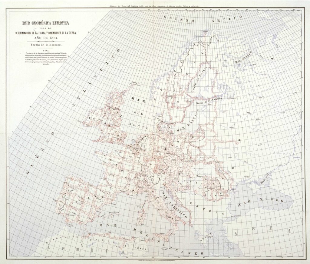
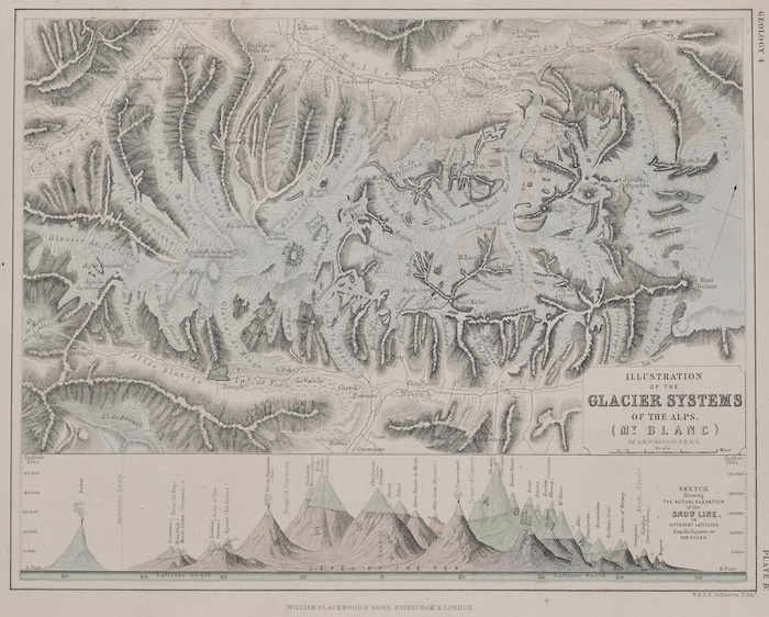
One of the primary themes running through Cartography in the Nineteenth Century, Volume Five of The History of Cartography, is the development of international cooperation in mapping. International teams collaborated on boundary surveys, but only because they had to [fig. 1]. More calculated cooperation was initially rather disorganized and incoherent: different groups of mapmakers and map scholars worked across national divides for various reasons. Nonetheless, cooperative efforts laid the foundations for further and more organized collaborations in the twentieth century that, among other things, shaped the study of map history and gave rise to The History of Cartography.
International Geodetic Cooperation
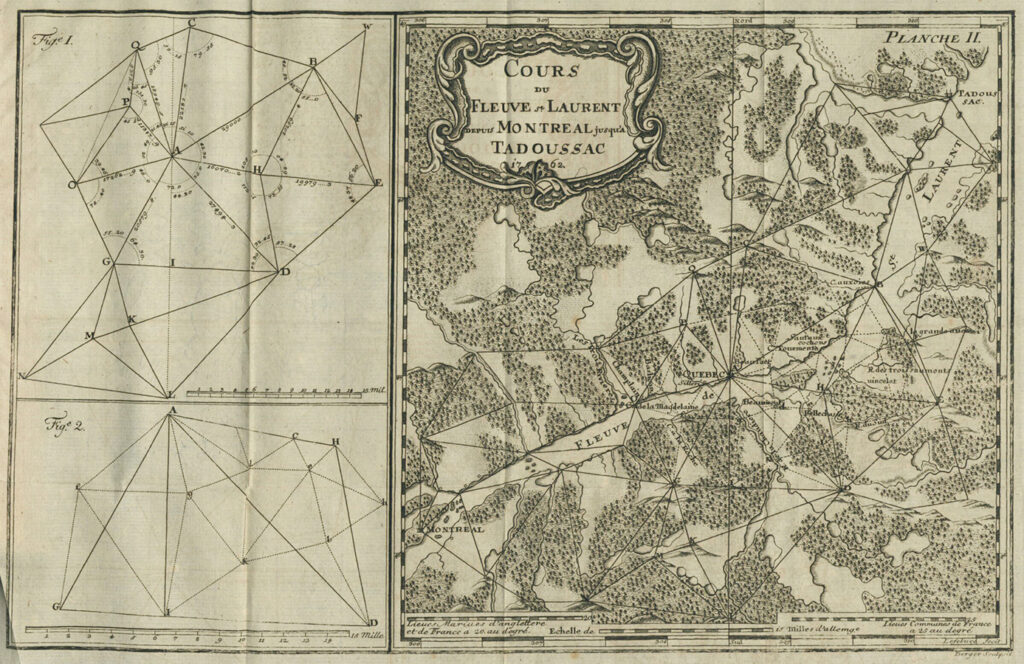
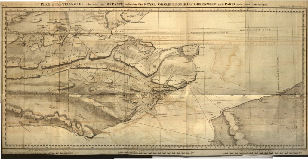
There had, of course, been some international elements to mapping endeavors before 1800, as described in Volume Four of The History of Cartography. Notably, there was a constant interchange among the engineers in the armies of Western Europe. For example, a French-born engineer, Simon Lefebvre, was recruited while serving in the Netherlands to work for Frederick II of Prussia, for whom Lefebvre wrote the Essai sur la maniere de faire les cartes (1762) [fig. 2]. An Austrian officer and surveyor, Anthony Troyer, ended up in southern India when his British patron, Lord William Cavendish Bentinck, became governor of Madras (modern Chennai); there Troyer set up a school to train infantry officers in land surveying, thus introducing the plane table to British India. The “remarkable” result of the networking and exchange of individual surveyors, as Brian Harley (1978, 45) wrote in one of his chapters on the mapping of the American Revolutionary War, was the “common approach to the making and use of maps” taken by the European militaries. The other main arena of international cooperation in the Enlightenment was in geodetic work to measure the size and shape of the earth. Spanish and Swedish scientists accompanied the French expeditions to Peru and Lapland to measure the earth’s size and shape in 1735–45, and British and French astronomers and geodesists collaborated in 1784–90 to measure the precise longitudinal distance between the observatories of Greenwich and Paris [fig. 3].
A primary goal of nineteenth-century geodesy was to link together the triangulation networks created by each state territorial survey in order to make geophysical studies more consistent. Put simply, geodesists, astronomers, and physicists came to realize that the earth is not actually a nice, neat spheroid but is actually an irregularly shaped body. (The modern term is that the earth is a “geoid,” which means an earth-like shape.) And until the actual shape, defined by its gravitational field, was determined, all sorts of problems could not be solved. Indeed, the British astronomer George Biddell Airy (1845, 165) held up geodetic studies of gravity as “affording the most satisfactory proof that we can expect ever to have” of Sir Isaac Newton’s “Principle of Gravitation.”
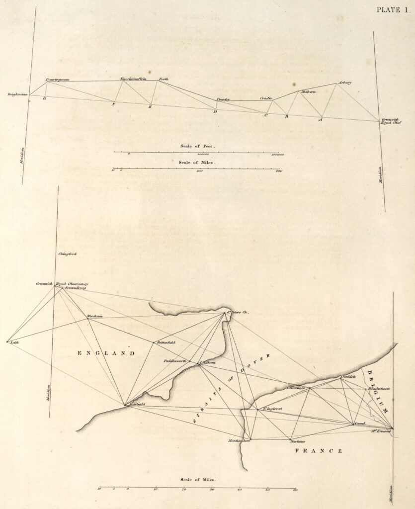
The completion of major geodetic surveys served to prompt further work to connect them all. Having published the final observations for his massive meridional arc through Russia from Finland to the Black Sea (1816–55), Wilhelm Struve traveled around Europe to promote the unification of all the triangulations across northern Europe. Struve’s proposal induced Airy to have the Ordnance Survey resurvey the longitudinal series from the west coast of Ireland to the Greenwich observatory and, with French cooperation, to extend that series to connect to the French and Belgian triangulations [fig. 4] (James 1863, iv). Struve’s cause was taken up by the retired Prussian engineer General Johann Jacob Baeyer, whose long memorandum convinced the Prussian authorities to support a mitteleuropäische Gradmessung (Baeyer 1861). Six other German states and nine other countries rapidly signed onto the plan, and the first international conference of the Central European Arc Measurement was convened in Berlin in 1864. The organization possessed a Central Bureau that managed operations, overseen by the Permanent Commission, which met annually, and the General Conference, which met every three years. In 1867, it was enlarged as the European Arc Measurement [fig. 5], which in turn was a founding partner in the formation in 1919 of the International Association for Geodesy (Torge 2007, 213–40; Torge 2015).
The International Map of the World
The spread after 1790 of systematic territorial mapping programs grounded in triangulation gave rise to the widespread expectation that all regional and even world mapping should be based on those surveys. Even if they were not currently grounded in territorial surveys, practitioners and even some members of the public anticipated that regional maps would eventually be so. The British geographer Julian Jackson—who had a suitably international career, first as an artillery officer in India (1808–13) and then as a staff officer for the imperial Russian general staff (1815–30) before retiring to London (Goudie 1978)—stated the expectation clearly in a mid-century textbook on cartography:
Thus, the interior of South America, though, to the eye, well filled in upon the [regional] map, offers but a distant approximation to truth; and when, in after years, the axe shall have cleared the secular forests of that portion of the New World, and the vast regions that extend from the Andes to the Atlantic, shall be covered with the abundant harvests and the habitations of a dense population, the [territorial survey] maps of the country then constructed will, upon a comparison with those now existing, show our descendants how wide of the truth were our [regional] maps in the position of many places, and how totally different the true course of its rivers from what we now figure them with such show of accuracy. (Jackson 1852, 164)
The spread of detailed topographical mapping was a marker of the advance of Western civilization. The British geographer John G. Bartholomew demonstrated the connection in a map included within the essay with which he introduced his XXth Century Citizen’s Atlas of 1908 [fig. 6]. Bartholomew used black for areas covered by triangulation-based systematic territorial surveys, red for topographical maps based on “surveys less exact in detail,” dark pink for reliable regional maps based on itineraries and numerous observations for latitude and longitude, and light pink for “general geographical maps” that “in many cases” are “only approximate or hypothetical.” Any areas left white were therefore “unexplored” by Westerners and any maps of them are “merely hypothetical.”
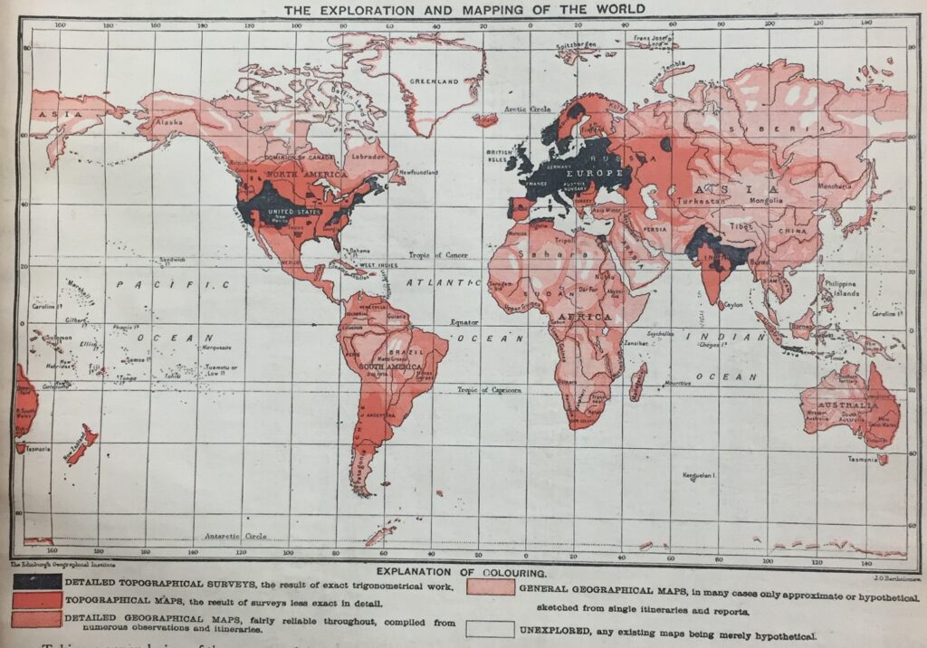
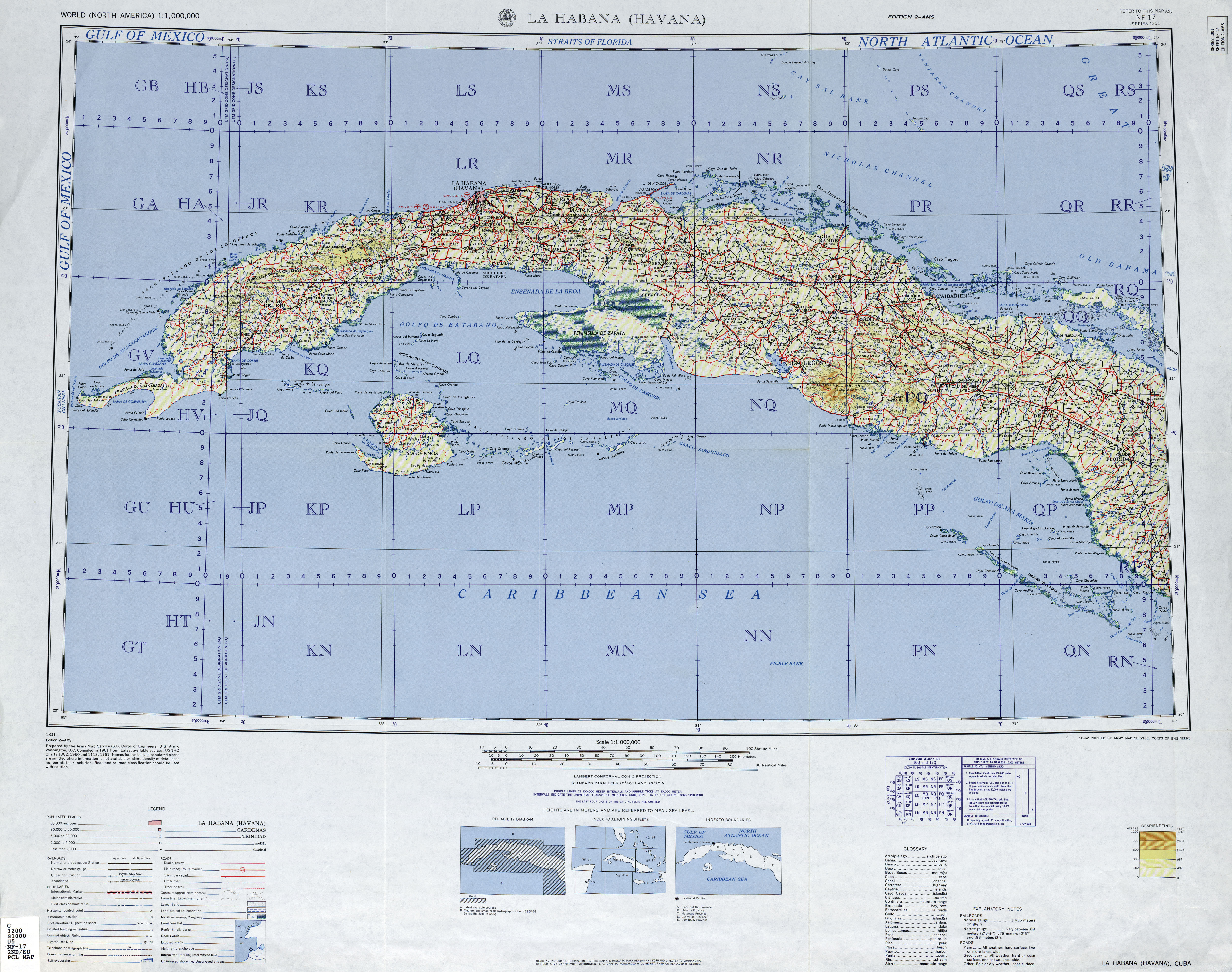
Bartholomew presented the territorial mapping of the world as an endeavor that was being pursued as an international and imperialistic effort by European states and their overseas colonies. A few years earlier, the German geographer Albrecht Penck (1892) had suggested that the global mapping effort be properly coordinated and organized by means of a standardized map series at 1:1,000,000 [fig. 7]. After twenty years of debate, in 1909–13, the official mapping agencies in Europe and the United States of America settled on a single set of standards and graphic conventions for the International Map of the World (IMW). World War I brought international cooperation to a crashing halt. Some participating mapping agencies, notably the U.S. Geological Survey pulled back from the project, although after the war the American Geographical Society made its Map of Hispanic America in 107 sheets in line with the IMW standards. World War II again interrupted work on the IMW, although the combatant states produced separate series covering Europe, North Africa, and western Asia at 1:1,000,000 for military planning purposes. After the war, the IMW became a “zombie project,” staggering on because of bureaucratic inertia—something that mapping agencies did because they had already been working on it for decades but with relatively little appreciation or commitment. After 1970, the different agencies involved slowly ceased publishing sheets as they retooled for digital map production, and the IMW was effectively, finally, terminated in 1989 (Pearson 2015; Rankin 2017).
On the other hand, the International Association for Geodesy and the IMW paved the way for a number of international collaborations in mapping. The extent is readily apparent in Cartography in the Twentieth Century, Volume Six of The History of Cartography, which includes a number of entries starting “International…,” from “International Cartographic Association” to “International Map of the World.” In this global age, any attempt at comprehensive mapping of the earth, its oceans, and its resources has to be based on international cooperation.
International Scientific and Cartographic Cooperation
The nineteenth-century international collaborations on geodetic and topographical surveys were paralleled by the rise of the environmental sciences and their further international collaboration. Geographers, geologists, botanists, zoologists, climatologists, physicists, and ethnographers all emulated the kind of field work that Alexander von Humboldt had popularized at the very start of the century. A variety of scientists funded by states and empires, by corporations and foundations, and by private means spread out to observe and measure the world and its inhabitants; they presented their results in a series of analytical maps in which they sought to espy the spatial laws of nature.
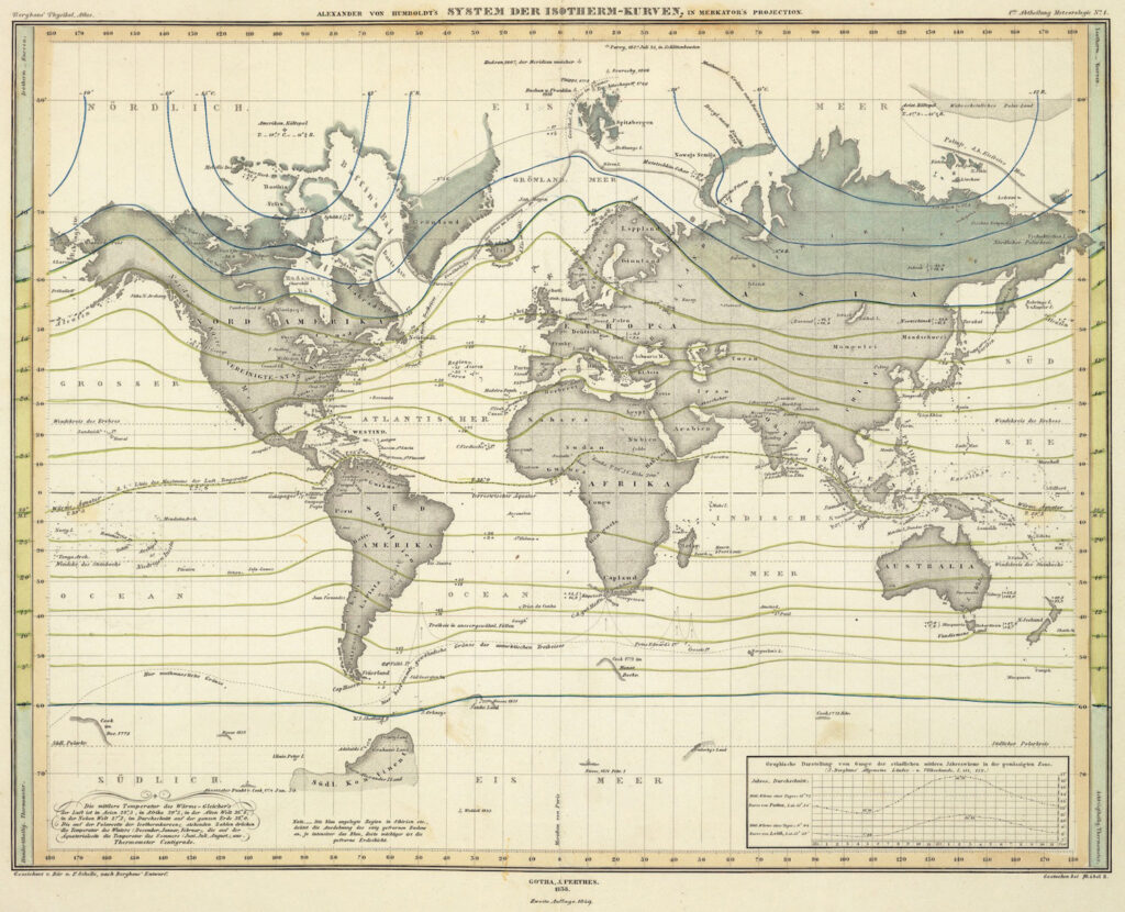
Humboldt worked with Heinrich Berghaus in Gotha in the creation of Berghaus’s grand Physikalischer Atlas (1845–48) that presented a composite of knowledge assembled by the international scientific community about meteorology and climatology [fig. 8], hydrology and hydrography, geology, terrestrial magnetism, botanical geography, zoological geography, anthropology, and ethnography (Camerini 1993). Seeking an international distribution of this work, Berghaus agreed in 1845 to have A. K. Johnston in Edinburgh publish an English-language edition [fig. 9]. Berghaus’s former student, August Petermann, went to Scotland to assist Johnston in the reproduction of the new maps, although he soon moved to London to work as an independent geographer in a Humboldtian vein [fig. 10] (Demhardt 2022). Although Petermann’s work was not necessarily appreciated (Withers 2019), his efforts established firm connections between German and British map publishers that continued through the century, dissolving only with the outbreak of war in 1914 (Scully 2010).
International Geographical Congresses and the History of Cartography
Over the course of the nineteenth century, different groups of scholars came together in international meetings to share data and ideas. The first International Geographical Congress (IGC) was convened in Antwerp in 1871, in large part to promote peace and cooperation after the Franco-Prussian War (1870–71) (Shimazu 2015). Later congresses became a site for all sorts of collaboration and proposals, including Albrecht Penck’s proposition for the International Map of the World during the fourth IGC, held in Bern in 1891.
From the start, the IGCs—and, after 1922, the International Geographical Union (Abler 2015)—promoted the study of the history of cartography. The exhibitions associated with each IGC prominently featured examples of the maps being made by national and commercial mapping agencies [fig. 11], but they soon also included displays of early maps. The Paris IGC in 1875 included an exhibition of early maps from the collections of the Archives nationales and the Bibliothèque nationale de France; the latter’s exhibits constituted “a complete history of cartography, comprising maps dating from the 7th century to the present time” (Anon. 1875, 403–4). The 1896 IGC in London, hosted by the Royal Geographical Society, had a large exhibition installed at the British Museum that included, in temporary housing, an “historical exhibition” organized by E. G. Ravenstein (Mill 1896, app. B, 125–51). Unfortunately, the published proceedings of the IGCs contain no photographs of these historical installations; I would be pleased to know of any that might survive!
In addition to presenting papers on map historical topics, participants in the IGCs established a number of commissions to promote the study of early maps by creating facsimile reproductions of key maps. They were not necessarily successful for three reasons: first, wars and other political tensions interrupted and undermined the internationalism of the congresses; second, the commissions were founded on the expectation that national governments would fund the production of the facsimiles, which did not happen; and, third, the commissioners could not agree on just which early maps needed to be reproduced. Charles Perron of Switzerland successfully proposed the formation of a Commission for the Reproduction of Early Maps at the 1908 Geneva IGC; its terms were reformulated in Rome in 1913 before being stopped by the outbreak of World War I. Roberto Almangià of Italy then had the 1928 Cambridge IGC establish a new Commission on Early Maps, with the goal of creating photographic facsimiles in the manner of his own Monumenta Italiae cartographica (1929); however, this commission staggered on through the 1930s without actually creating the putative Monumenta Europae cartographica (Bagrow 1935; Bagrow 1939).
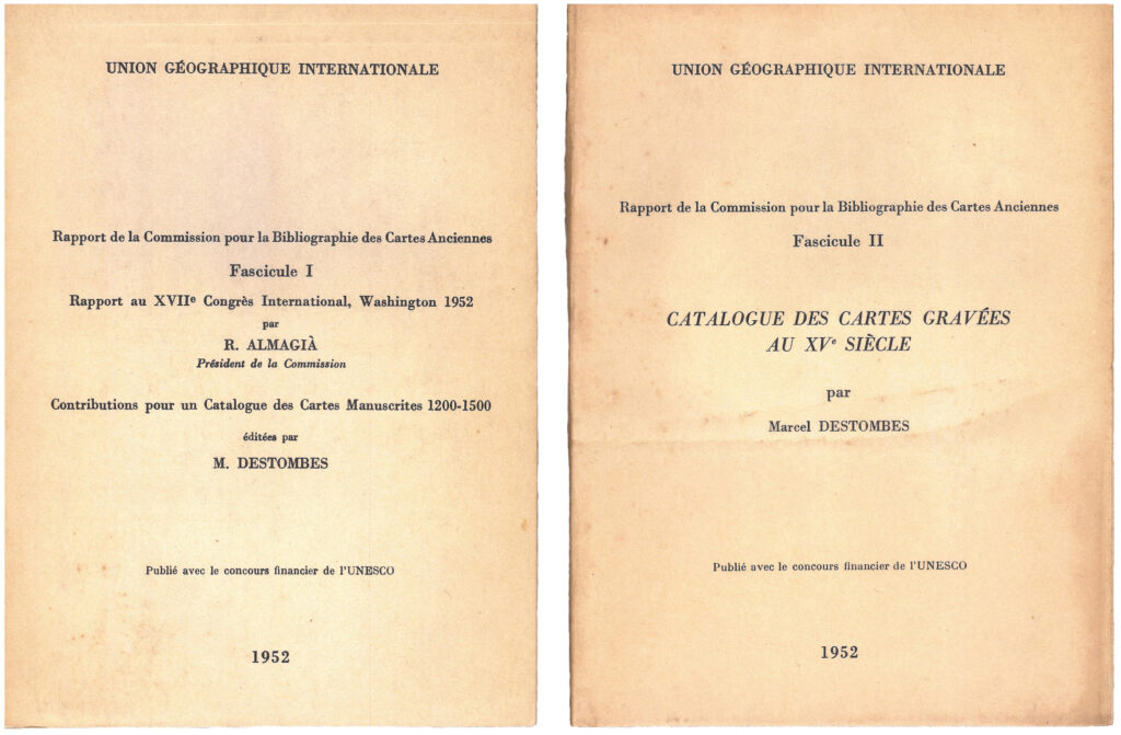
It was only after World War II that Almagià’s commission had any success. The 1949 Lisbon IGC reconfigured it, at his suggestion, as the Commission for the Bibliography of Early Maps, on the principle that a thorough, international bibliography of early maps was needed to establish the priority of eventual facsimile reproductions (Skelton and Codazzi 1949; Almagià 1952). For the 1952 congress in Washington, Almagià prepared an outline report of progress [fig. 12] with example entries for a catalog of mappaemundi (Destombes 1952b) and a preliminary checklist of early printed maps (Destombes 1952a). However, even as the commission published Marcel Destombes’ bibliography of mappaemundi (Destombes 1964), the 1964 London IGC voted to downgrade the commission to a working group. The reasons for the decision remain unclear. I tend to agree with Brian Harley (1987, 19) that the downgrading resulted from geography’s “quantitative revolution,” which made the standard practices of map historians seem outmoded and unscientific.
As it happened, the London congress was the occasion for a special, two-day symposium—one of fourteen associated with the congress—dedicated to the history of cartography. It was organized at the Royal Geographical Society by G. R. Crone, with the assistance of R. A. Skelton and Helen Wallis from the British Museum Map Room. The speakers present came from Belgium (1), Canada (1), France (3), Ireland (2), the Netherlands (1), Portugal (1), the UK (3), and the USA (5); overall, fifty-eight people attended. Crone revealed his reasons for organizing the symposium in the final session, an open discussion of the “present state and future prospects” of map history. Thirty years previously, he argued, Edward Lynam in the British Museum and Edward Heawood in the Royal Geographical Society had labored almost alone on map history in Britain. Yet, Crone continued, the considerable post-war growth in British map historians had not been matched by any increase in intellectual standards. What the field needed, and what Crone hoped to stimulate with the symposium, was a more academic character (Crone, Skelton, and Wallis 1967).
The symposium was a success, and many of the papers were published in Imago Mundi, edited by Skelton, which had been published in Britain since Leo Bagrow’s death in 1957. In fact, Crone, Skelton, and Wallis promptly organized a second, now stand-alone symposium in 1967, under the aegis of Imago Mundi, Ltd., of which Crone and Skelton were directors (Harley 1968). The two London conferences were retroactively claimed as the first two International Conferences on the History of Cartography, when Imago Mundi, Ltd., convened what it called the third ICHC in Brussels in 1969. The biennial meetings of the ICHC have subsequently served as an institutional anchor for all kinds of map historians (Sims and Van der Krogt 1995).
The History of Cartography
The International Conferences on the History of Cartography were essential in growing the field of map history by making new and essential international connections [fig. 13]. In particular, in 1969, the third ICHC in Brussels saw the first meeting in person of David Woodward, just hired as the first map curator at the Newberry Library in Chicago, and Brian Harley, then working as an acquisition’s editor for David & Charles publishers, in Newton Abbot, Devon. (To be honest, it was not much of an international encounter, as the British-born Woodward had emigrated to the USA in 1964.) The two men hit it off, not least over their shared desire for the field of map history to become more academically sound.
Eventually, Woodward and Harley agreed in 1977 to collaborate on a four-volume History of Cartography. Their intent was to use the History to lay a new foundation for the field by assessing what was known about mapmaking in the past (Edney 2015). They could not have even begun to think of such an endeavor without the connections that they made with the international field of map historians through the ICHCs. While broadly knowledgeable, they would not themselves be able to write about many specific topics and subjects. The remarkable thing about the History—what makes the series so different from a single-author monograph—has been its reliance on the international community of scholars who have combed the literature in multiple languages to provide the necessary detailed information and variant perspectives; thus, Cartography in the Nineteenth Century has 408 entries written by 179 scholars working in 29 different countries. Conversely, the History has been an avenue to spread an academic perspective through the field. As a result, the character of the ICHC has changed significantly over the decades!
It has not been a straight line from Simon Lefebvre and the transnational military engineers of the eighteenth century to the volumes of The History of Cartography, but the trajectory has been only slightly curved! Mapmaking inevitably became ever more international in its organizations and collaborations in order to map the entire world. The study of maps and their history similarly internationalized by necessity, in part to attain the needed perspective, in part to distribute the labor, effort, and cost to make map history feasible.
Matthew Edney
References
Abler, Ronald F. 2015. “International Geographical Union.” In Cartography in the Twentieth Century, ed. Mark Monmonier, 677–79. Vol. 6 of The History of Cartography. Chicago: University of Chicago Press.
Airy, George Biddell. 1845. “Figure of the Earth.” In Encyclopaedia Metropolitana, ed. Edward Smedley, Hugh James Rose, and Henry John Rose, 5:165–236, *237–*240. 29 vols. London: B. Fellows et al.
Almagià, Roberto. 1929. Monumenta Italiae cartographica. Florence: Firenze Istituto.
———. 1952. “Rapport au XVIIe congrès internationale, Washington, 1952.” In Rapport de la commission pour la bibliographie des cartes anciennes, 2 vols., 1:5–20. [Paris]: Union géographique internationale.
Anonymous. 1875. “The Geographical Congress, No. IV.” Engineering: An Illustrated Weekly Journal 20 (19 November 1875): 403–5.
Baeyer, Johann Jacob. 1861. Über die Größe und Figur der Erde, eine Denkschrift zur Begründung einer mitteleuropäischen Gradmessung. Berlin: Georg Reimer.
Bagrow, Leo [attrib.]. 1935. “Übersicht der Tätigkeit Internationaler Geographenkongresse auf dem Gebiete der Geschichte der Kartographie.” Imago Mundi 1:65–68.
——— [attrib.]. 1939. “16th International Geographical Congress, 1938.” Imago Mundi 2:100–102.
Bartholomew, John G. 1891. “The Mapping of the World.” Scottish Geographical Magazine 6:293–305, 575–97, and 7:124–52, 586–611.
Berghaus, Heinrich. 1845–48. Dr. Heinrich Berghaus’ physikalischer Atlas oder Sammlung von Karten, auf denen die hauptsächlichsten Erscheinungen der anorganischen und organischen Natur nach ihrer geographischen Verbreitung und Vertheilung bildlich dargestellt sind. 8 parts in 2 vols. Gotha: Justus Perthes.
Camerini, Jane R. 1993. “The Physical Atlas of Heinrich Berghaus: Distribution Maps as Scientific Knowledge.” In Non-Verbal Communication in Science prior to 1900, ed. Renato G. Mazzolini, 479–512. Florence.
Crone, G. R., R. A. Skelton, and Helen M. Wallis. 1967. “Report of Symposium 13a: The History of Cartography.” In Congress Proceedings: 20th International Geographical Congress, ed. J. Wreford Watson, 251–59. London: Nelson.
Demhardt, Imre Josef. 2022. “‘To what extent you have to be satisfied with your situation there …’: August(us) Petermann in Britain, 1845–1854.” Imago Mundi 74:241–76.
Destombes, Marcel. 1952a. “Catalogue des cartes gravées au XVe siècle.” In Rapport de la commission pour la bibliographie des cartes anciennes, 2 vols., 2:3–95. [Paris]: Union géographique internationale.
———. 1952b. “Contributions pour un catalogue des carte manuscrits, 1200–1500.” In Rapport de la commission pour la bibliographie des cartes anciennes, 2 vols., 1:21–63. [Paris]: Union géographique internationale.
———, ed. 1964. Mappemondes A.D. 1200–1500: Catalogue préparé par La commission des cartes anciennes de l’Union Géographique Internationale. Amsterdam: N. Israel.
Edney, Matthew H. 2015. “History of Cartography Project.” In Cartography in the Twentieth Century, ed. Mark Monmonier, 614–16. Vol. 6 of The History of Cartography. Chicago: University of Chicago Press.
Goudie, A. S. 1978. “Colonel Julian Jackson and His Contribution to Geography.” Geographical Journal 144, no. 2:264–70.
Harley, J. B. 1968. “Conference on the History of Cartography, London, September 1967.” Imago Mundi 22:9.
———. 1978. “The Spread of Cartographical Ideas between the Revolutionary Armies.” In Mapping the American Revolutionary War, by J. B. Harley, Barbara Bartz Petchenik, and Lawrence W. Towner, 45–78. Chicago: University of Chicago Press.
———. 1987. “The Map and the Development of the History of Cartography.” In Cartography in Prehistoric, Ancient, and Medieval Europe and the Mediterranean, ed. J. B. Harley and David Woodward, 1–42. Vol. 1 of The History of Cartography. Chicago: University of Chicago Press.
Hornsby, Stephen J. 2011. Surveyors of Empire: Samuel Holland, J. F. W. Des Barres, and the Making of The Atlantic Neptune. Montreal: McGill-Queen’s University Press.
Jackson, J. R. 1852. “Chartography.” In A Manual of Geographical Science, Mathematical, Physical, Historical, and Descriptive, ed. Charles Grenfell Nicolay, 1:143–84. London: John W. Parker and Son.
James, Henry. 1863. Extension of the Triangulation of the Ordnance Survey into France and Belgium: With the Measurement of an Arc of Parallel in Latitude 52ºN. from Valentia in Ireland to Mount Kemmel in Belgium. London: George Edward Eyre and William Spottiswoode for Her Majesty’s Stationery Office.
Kershaw, Kenneth A. 1993–98. Early Printed Maps of Canada. 4 vols. Ancaster: Kershaw Publishing.
Mill, Hugh Robert, ed. 1896. Report of the Sixth International Geographical Congress, Held in London, 1895. London: John Murray.
Pearson, Alastair W. 2015. “International Map of the World.” In Cartography in the Twentieth Century, ed. Mark Monmonier, 689–93. Vol. 6 of The History of Cartography. Chicago: University of Chicago Press.
Penck, Albrecht. 1892. “Die Herstellung einer einheitlichen Erdkarte im Massstabe von 1:1 000 000.” In Compte Rendu du Vme Congrès International des Sciences Géographique tenu à Berne du 10 au 14 août 1891, 191–98. Bern: Schmid, Francke.
Rankin, William. 2017. “Zombie Projects, Negative Networks, and Multigenerational Science: The Temporality of the International Map of the World.” Social Studies of Science 47, no. 3:353–75.
Scully, Richard. 2010. “‘North Sea or German Ocean’? The Anglo-German Cartographic Freemasonry, 1842–1914.” Imago Mundi 62:46–62.
Shimazu Toshiyuki. 2015. “War, Peace, and a Geographical Internationalism: The 1871 Antwerp International Geographical Congress.” Geographical Reports of Tokyo Metropolitan University 50:97–105.
Sims, Douglas W., and Peter van der Krogt. 1995–. “The International Conferences on the History of Cartography: A Short History and Bibliography of Papers.” http://www.explokart.eu/ichc/.
Skelton, R. A., and Angela Codazzi. 1949. “International Geographical Congress, Lisbon, 1949.” Imago Mundi 6:93–95.
Torge, Wolfgang. 2007. Geschichte der Geodäsie in Deutschland. Berlin: Walter de Gruyter.
———. 2015. “From a Regional Project to an International Organization: The ‘Baeyer-Helmert-Era’ of the International Association of Geodesy, 1862–1916.” In IAG 150 Years: Proceedings of the 2013 IAG Scientific Assembly, Potsdam, Germany, 1–6 September 2013, ed. C. Rizos and P. Willis, 3–18. Cham: Springer.
Withers, Charles W. J. 2019. “On Trial: Social Relations of Map Production in Mid-Nineteenth-Century Britain.” Imago Mundi 71, no. 2:173–95.