
Putting Maps Back into Context
An in-depth look at the importance of the settings in which maps have been made and used, highlighted in our 2021 Outreach Letter.
“Context is everything ….” This was the argument of Peter Barber’s (2020) reflections on the profound changes that the field of map history has undergone since he began studying early maps in the late 1970s. Building on a wealth of experience and first-hand knowledge, the former chief map librarian in the British Library and current associate editor for Cartography in the Nineteenth Century, Volume Five of The History of Cartography, argued that the changes lay in the new attention paid by map historians to placing maps within their appropriate social and cultural contexts. Indeed, Barber identified the work of Brian Harley and David Woodward—especially the ethos and vision of the History as they began soliciting contributions in the 1980s—as a major impetus for this new scholarly direction. An important but often unrecognized element in the study of maps as cultural documents and social instruments has been the particular need to clarify the maps’ original physical contexts.
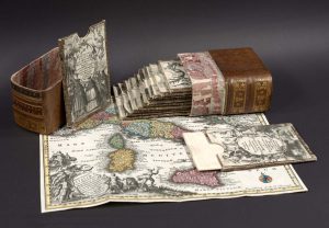
Fig. 1. Vol. 1 of Matthäus Seutter, Atlas historique (Augsburg, 1730), from the Osher Map Library and Smith Center for Cartographic Education, University of Southern Maine (Smith Collection). Click on image to see map in high-resolution.
The key issue is that over many centuries, maps have routinely been removed from their original contexts without clear records being kept. These practices have been extensively countered and halted since the 1970s, however they have left a legacy that requires great effort to overcome. But that effort always pays off: resituating early maps in the original contexts of their production, circulation, and use inevitably allows for more new interpretations of their meaning and significance.
Two contributors to the later volumes of the History—Jordana Dym and Carla Lois, who is also a coeditor of Volume Five—have recently published a powerful essay about the issue (Dym and Lois 2021). They highlight how the treatment of maps as “sovereign” things, “as individual images separated from the material context of their production, circulation, and consumption,” has woefully restricted modern interpretations and studies. They instead remind us that many early maps were “bound images”; they were part of books and could constitute the major part of a book. Maps in books need to be considered by bibliographers and historians of the book, and map historians must consider how the maps they study fit within the parent works.
Consider the example of the Severan Marble Plan of Rome (fig. 2). Since the first set of fragments of this stone-engraved map were found in the mid-sixteenth century, this map has been studied as a prime example of the practice of Roman engineers to engrave detailed plans of properties, communities, and cities in stone and bronze. The bronze plans might have long since been melted down and repurposed, but many stone-engraved plans have survived, if only in fragmentary form. Figure 2 shows almost an entire slab, recording an imperial [horse] changing station (mutatorium Caesaris), a customs post or vegetable market (area labeled Radicaria) outside the porta Capena, a New Street (via Nova), and the Appian Way (via Appia).
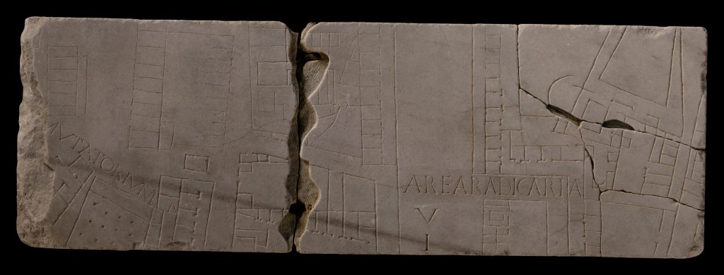
Fig. 2. Fragments 1a–e of the Severan Marble Plan, or Forma Urbis Romae, a third-century CE map of the city of Rome engraved in marble slabs, which shows the ground plans of buildings in remarkable detail. Fragments were first found in 1562, with many more brought to light during nineteenth-century excavations; they now total 1,186 known fragments, in addition to some lost fragments known from early modern prints. The plan is the object of a major study by Stanford University, source of the image.
But where did the fragments come from? Where was the plan housed and seen? After a great deal of work, archaeologists have determined that the plan comprised 150 marble slabs that were mounted onto a wall within the complex of the Templum Pacis (Temple of Peace) in 203–11 CE and then engraved in situ. The whole measured 18 × 13 meters, and its base was mounted a couple of meters from the floor. The upper portions would not have been visible to a viewer. That is, the plan was not a utilitarian or instrumental work, but rather a map explicitly intended for display as an image of the essence of Rome as a built environment, emphasizing only a few of the major monuments; what was important was the impression of the entire map (Reynolds 1996; Trimble 2008).
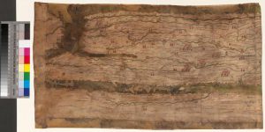
Fig. 3. First of eleven segments, showing Britain and France, of the Peutinger map in the Österreichische Nationalbibliothek (Cod. 324); the segments were originally joined to form a scroll, 34.0 × 674.5 cm. Click on image for ONB digital collections record; then, to see all map segments in high-resolution, click “zum Digitalsat.”
Generally speaking, the loss of physical context is due not to physical deterioration but to human action. In the early modern era, original location and character was only of marginal interest, if not completely irrelevant, and was overlooked. We know, for example, that Konrad Celtis (1459–1508) acquired the medieval copy of a Roman scroll map of the imperial road network (fig. 3) in about 1500 and soon gave it to Konrad Peutinger (1465–1547) in Augsburg. We can trace the map’s movement between dealers and libraries until it found its current home in 1737 in the library of the Austrian Habsburgs, the core of the modern Austrian national library. But we have no knowledge of where Celtis found the map. Knowing that might allow scholars to infer something more concrete about who had had the map made and why they had done so, which might in turn suggest how the original map would have been seen and used during the later Roman empire (see Talbert 2010).
Early modern antiquaries treasured ancient and medieval objects as much for the tangible connection they made to the past as for what they might say about the past. As with the Severan Marble Plan and the Peutinger map, scholars have to expend a great deal of effort to wring out every last drop of information that they can about how such early maps were made, which might then permit them to be placed in their proper contexts. In the case of the Gough Map of Britain (fig. 4), whose origins were utterly unknown when it surfaced in the early eighteenth century, careful physical analyses have revealed it to have been made in three stages in about 1400: a first, incomplete map of the whole of Britain, followed by an extensive reworking of England and Wales, and then by the re-inking of placenames in southeastern and central England. It thus stands as a working document of administrative reference, intended to be laid out on a table to serve as the focal point of discussion and also to be kept up to date and usable (Delano-Smith et al. 2017; Delano-Smith 2019).
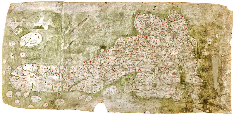
Fig. 4. The so-called Gough Map of Britain, ca. 1400 (Bodleian Library, University of Oxford, MS. Gough Gen. Top. 16); 56 × 115 cm. For a detailed study of this map, with high-resolution imagery, see the Bodleian’s Linguistic Geographies project.
In about 1800, early modern antiquaries transformed into modern archaeologists, local historians, librarians, archivists, and museum curators (Beckett 2007; Gaimster et al. 2007). A hallmark of their practice remained the removal of objects from their original contexts so that they might be rehoused and recontextualized within new temples of knowledge (Duncan and Wallach 1980, esp. 448–49; Bennett 1995, 19–20). This was especially the case in the collecting of materials from the rapidly expanding imperial territories within dedicated museums (Edney 1997, 39–76; Ratcliff 2019).
A prime example of the repeated decontextualization of objects, including maps, is offered by the so-called Wise Collection, now in the British Library (BL). This collection comprises fifty-five glorious manuscript “picture maps” (fig. 5) and other images from nineteenth-century Tibet. The maps and drawings have Arabic numerals added that point the reader to some 900 English-language annotations in the same hand on separate sheets of paper. The whole was given to the library of the India Office (IOL), the government department in London responsible for the administration of South Asia between 1858 and 1947. They were integrated into the IOL’s series of “additional oriental manuscripts,” as Add. Or. 3013–43. (You can consult the full set of materials at https://imagesonline.bl.uk/, by searching for “Add. Or. 30xx” [spaces essential!].) The materials were then bound into three large volumes, probably in the 1890s, their spines embossed with the manuscript numbers and the name “Wise.” With the dissolution of the India Office, the IOL briefly resided with the Foreign and Commonwealth Office before being merged in 1967 into the stand-alone India Office Library and Records (IOLR); IOLR was in turn incorporated into the BL in 1982 and its holdings progressively merged into the rest of the BL’s collections. IOL librarians had thought the images to be “rather pleasing curiosities” instead of objects of actual intellectual “value” (Lange 2020, ix); once in the IOLR, the phenomenal collection of images became visible to Tibetologists, who immediately recognized its historical significance.
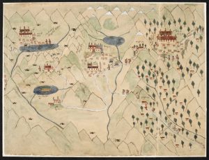
Fig. 5. An anonymous map of part of the border region between Tibet and present-day Arunachal Pradesh in northeastern India and Bhutan; the right part of the map is oriented to the south. British Library, London (Add. Or. 3017, fol. 6).
So, who was Wise? How had he assembled this information? Had he written the English-language annotations? If not, then who? And when, and where? And who had done the drawings, plainly the work of a Tibetan? Nobody knew. IOL’s own archives were unforthcoming. In this respect, the Wise Collection stands as the exemplar of the decontextualization of materials by the agents of the modern European empires.
Fortunately, Diana Lange has undertaken the careful detective work necessary to situate these maps and drawings properly. Thomas Alexander Wise (1802–89), originally from Dundee, Scotland, had served in Bengal in the medical corps before returning to Britain in 1851. He accumulated a large “cabinet of curiosities” of materials about northern India and Tibet, which in 1885 he donated to University College Dundee. As befits such a cabinet—a very early modern concept—he made no record of where he had acquired his jumble of materials. Some of the Tibetan items in Dundee bear the same English annotations as the BL maps. Why Wise split the materials, giving some to the IOL, is unclear, although Dundee seems to have received the cultural objects and IOL the manuscripts and drawings.
Where did Wise collect the maps and drawings that ended up in the IOL and are now in the BL? Which Briton had apparently commissioned them from a Tibetan informant? Eventually, in searching the records of a short list of British officials active in the Himalaya in the mid-nineteenth century, Lange encountered an article on Tibetan funerary practices—a topic with which Europeans were uniformly fascinated as a marker of cultural difference—which reproduced two drawings in the same hand as that which had annotated the Tibetan maps. Those drawings were by a British agent in the western Himalaya, William Edmund Hay (1805–79). Lange was able to conclude that Hay had solicited the maps and drawings from a lama—unfortunately still anonymous—who had been traveling from Lhasa into India; the lama had reached the routes leading down into the lowlands, but news of the 1857 uprising against the British East India Company had stopped him from going further. Hay had time to commission the drawings and then interrogate the lama further about what he had drawn and mapped. With this context established, Lange has been able to study the maps and drawings of eastern Tibet, confident in the knowledge that they were created by a resident of that region. The result is her beautifully illustrated book, An Atlas of the Himalayas by a 19th Century Tibetan Lama (2020) and also her entry on the Wise Collection in Cartography in the Nineteenth Century, the final volume to be prepared in The History of Cartography series.
The early nineteenth century saw the coeval development of map libraries and a new field of study that by 1840 was being called the “history of cartography” (Jomard 1840, 438; Santarém 1842, xiv n. 4, xvi). The new breeds of librarian and historian both focused on the content of geographical maps and marine charts, especially their delineation of gross features (coastlines, rivers, mountains) and placenames. As ever, other aspects of the maps that were collected and studied were largely irrelevant and so were mostly ignored. We can see this factor at play in the work of one of the first map historians, Edme-François Jomard (1777–1862).
Jomard is especially remembered by map historians for his large collection of facsimiles of early maps (fig. 6), which he made in competition with the similar collections assembled by the viscount of Santarém (1791–1856). He did not live long enough to complete the atlas, but he left a draft of the planned introductory text that explained the rationale for organizing a chronological sequence of maps of the world:
This well-executed enterprise will be, in a way, a history of geography according to maps, a history written by itself, that is to say, by its graphic productions; it will thus be the most authentic and the most certain of histories. (Jomard 1879, 4–5) [n1]
Fig. 6. Sheet 3 of Edme-François Jomard’s facsimile of Gerhard Mercator’s 1569 world map, in his Les monuments de la géographie, ou recueil d’anciennes cartes européennes et orientales (1854). For a high-resolution image, click on map. Lithograph, 73 cm high (paper). The entire work is available through the University of Pittsburgh.
A chronological sequence of maps covering the same region would demonstrate the progressive accumulation of geographical knowledge over time, serving as a surrogate for tracing the rise of civilization.
Jomard had begun his career as a topographical engineer and had worked on the mapping of Egypt during the ill-fated Napoleonic invasion (1798–1801). He had later become chief editor of the many large volumes of the Description de l’Égypte (1809–22) that presented the intellectual results of the invasion. Politically connected friends later had a special position created for Jomard as curator of geography within the Bibliothèque royale in Paris (now the Bibliothèque nationale de France) in 1828. Inevitably incurring the jealousy of the library’s other curators, Jomard’s department was soon subordinated to the department of prints and later that of printed books; in fact, an independent map library, the Département des cartes et plans, was established in the Bibliothèque nationale de France only in 1942 (Bus 1931; also Laissus 2004, 392–420, 516–18; Richard 2010).
Jomard was acutely aware of the need, if he was to preserve or reclaim his autonomy, to distinguish maps and atlases from books (see also Jomard 1841). In his first statement of map librarianship, Jomard argued for the fundamental difference of maps from books:
As a geometric projection of the earth, of its features and divisions, a map is already a scientific work entirely distinct from a book. Indeed, there is almost nothing in common between the one and the other. These two works of the mind and the hand teach by means which differ as much as their own, inner natures. If maps have often been added to books, it is because readers could not do without their help; while in a very great number of cases, and even in almost all cases, a map can do without the help of any book. We read a book. We perceive, so to speak, a map. A book is read word by word, and page by page; a map allows you to cover a whole subject at once. (Jomard 1831, 9) [n2]
Moreover, to use maps efficiently, they needed to be housed as sheets that could be spread on a table or hung on a wall for ease of consultation:
Will it be said that maps must be treated as books because they can be bound like them and gathered in volumes? But this objection [to a separate map library] is weak, even unfounded, because an atlas does not allow the most convenient form for maps, far from it. No, maps must be isolated, placed on shelves, or else rolled up and hung in the English manner. [n3]
This was, however, far more than simple rhetoric. Jomard’s political arguments were grounded in the general appreciation of geographical and territorial maps (like those of the eighteenth-century Carte de France or the post-Napoleonic Carte de l’état-major) as providing synopses of accumulated geographical information. Maps and books deserved to be distinct. More and more map libraries were established in the course of the nineteenth century and their librarians all sought to collect maps as separate and stand-alone entities, removed as necessary from the books, atlases, and other contexts that had originally housed them.
The organization of maps by region, first and foremost, has been naturalized by innumerable published map catalogs and cartobibliographies. To my mind, the exemplar is the bibliography by James Clements Wheat and Christian F. Brun (1969) of maps printed in North America before 1800. Wheat and Brun list the maps by region—the world, North America, Canada, United States, US regions and constituent states, West Indies, etc.—and then by publication date. The parent work of each map is partially obscured (a short citation leads to a bibliography in which primary and secondary sources are intermingled). While useful for the identification of particular maps, it is next to impossible to use the bibliography to understand either how maps related to other maps in their parent works or of the patterns of map publication in early America. When one works to explore the different forms of printed maps in early America, we soon see how few were issued as separate works, how most were integral parts of books, and how the few separate works were intended for display on walls (see esp. Brückner 2017).
![Plan of Part of the District of Main[e]](https://geography.wisc.edu/histcart/wp-content/uploads/sites/12/2021/11/Fig.-7-1-300x257.png)
Fig. 7. Plan of Part of the District of Main (n.p., n.d.), but certainly engraved and printed in London by William Faden for William Bingham of Philadelphia in 1794. This image is from the Library of Congress, although it is not online; click on the map for a high-resolution image from the John Carter Brown Library.
There are, of course, pragmatic factors that require librarians and archivists to actively separate maps from parent works. One is that most users of libraries have traditionally been interested in knowing about specific regions and places; separating the maps from the books facilitates consultation. The other is that maps are often larger than their parent works and need to be housed separately for proper preservation. Yet, in separating maps from parent books, librarians and archivists have long neglected to maintain a record of each map’s parent work. For example, some years ago I was exploring the archives of Baring Bank (now part of the ING group). In the 1790s, the Barings negotiated with William Bingham (1752–1804) over the purchase of some of his extensive lands in Maine, and young Alexander Baring (1774–1848, future first Baron Ashburton and Bingham’s son-in-law) traveled to Maine to inspect the lands. His letters to his father referenced several maps and plans, none of which were with the letters housed in the bank’s main archival reading room. The maps were at that time kept in a separate storage facility; I was very pleased to be able to tell the archivist that certain maps went with specific letters, all impressions of Bingham’s map of his lands (fig. 7) that Alexander had variously annotated. Most map historians who have worked in archives will have similar stories of reuniting maps and letters; the significance of the maps is so much greater once they have been reunited!
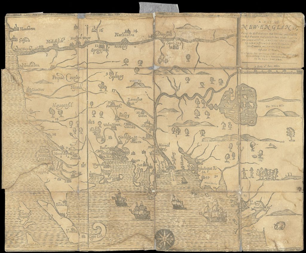
Fig. 8. William Hubbard, A Map of New-England, the “White Hills” map, from his Narrative of the Troubles with the Indians in New-England (1677a), from the Osher Map Library and Smith Center for Cartographic Education, University of Southern Maine (Osher Collection). Click on image to see map in high-resolution.
Moreover, the practices of dealers and collectors of antiquarian maps have exacerbated the problem. Early modern map collectors sorted the contemporary maps they acquired by region, often breaking atlases in order to distribute their maps through a large collection (Pedley and Edney 2019). As these early collections were broken up for sale and auction, loose maps circulated in the marketplace to be acquired by others. In the early nineteenth century, collectors increasingly sought to acquire old maps to give historical depth to their collections. Maps (and prints) began to be pulled from books. The exemplar in this respect was William Hubbard’s map of New England, the first map to be printed in North America. This primacy has made the map of great interest to collectors. However, the map is known in two versions, commonly called the “White Hills” (fig. 8) and the “Wine Hills” (fig. 9) maps, after an obvious point of difference; the two versions of the map are associated with both Boston and London editions of the parent book. By 1887, however, dealers had so complicated the books—extracting the maps to sell separately, reinserting maps to make a complete book; on some occasions inserting both maps for extra authenticity; using facsimiles when no original map was at hand—that it was no longer possible to say which map went with which book.
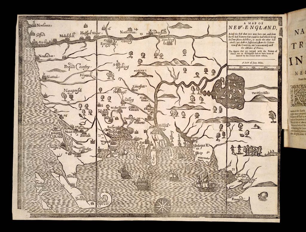
Fig. 9. William Hubbard, A Map of New-England, the “Wine Hills” map, from his Present State of New-England (1677b), from the Osher Map Library and Smith Center for Cartographic Education, University of Southern Maine (Osher Collection). Click on image to see map in high-resolution.
The collector and bibliographer Charles Dean lamented the problem. Although he placed blame on the dealers, he should also perhaps have blamed the desires of collectors:
If a certain number of copies of the London edition and of the Boston edition of Hubbard’s book, with the maps, could be found, showing from their appearance and their places of deposit that they were as intact as when they came from the hands of the original binder, some light might be thrown upon the question as to which of the two maps was originally placed in each. But it is very difficult to find such volumes in this instance as in that of other books. For if they escape the contingencies of careless usage and the blight of time, they do not escape the hand of the spoiler,—I mean the book-dealer,—who often robs Peter to pay Paul, in filling orders for his customers; and the work of mutilation goes on. Books are robbed of their integrity, and those volumes for which the robbery is made, owing to ignorance or indifference, are often supplied with illustrations—maps and plates—which do not belong to them. This is an evil greatly to be deplored, for historical investigation is often thwarted by the existence of such books. (Deane 1887, 14)
In the end, Randolph G. Adams (1939) was able to study a sufficient number of books in their original bindings to say that the White Hills map went with the Boston book, the Wine Hills with the London book. Thereafter, David Woodward (1967) delved into the details of the cutting of the woodblocks for the two maps, and the insertion of foundry type into the blocks for the title block and for some of the placenames, to show that the inserted foundry type was the same as that used in setting the respective books; the type in the White Hills map was the same as the type used for the Boston book.
But this conclusion resolves only part of the problem. It established which of the map variants should be honored as the first map printed in North America as a marker of the transfer of Western civilization to the new world. But what more can we say about the map now that we know its physical context? One thing is that the map can be read for its contribution to the parent book. Hubbard was concerned with elucidating the role of providence in the English victory over Metacomet (King Philip) in the vicious war in 1675–76. The map was not only a graphic index to the section in the middle of his book in which he listed the atrocities of Indians against the English (while largely ignoring the atrocities perpetrated by the English); in addition, its factual and empirical claims were part and parcel of Hubbard’s arguments against the interpretation of the history of the war by the leading Puritan preacher, Increase Mather, who argued that divine intervention had given the English victory only once Mather himself had led all the English in Massachusetts Bay to renew their covenant with God.
With the maps in their physical contexts, it also becomes clear that the intended function of the two maps was different: in the Boston edition, the map was bound in the middle of the book, with the summary of events in the conflict. It was clearly intended to be read in conjunction with that summary. In the London edition, which Hubbard had no hand in producing, the map was bound facing the title page (shown in fig. 9) where it served as a guide to the geography of New England and the events of war to an English readership who were less concerned with the niceties of perceiving divine intervention in Puritan theology (Edney and Cimburek 2004).
Fig. 10. François du Creux, Tabula Nova Franciae Anno 1660, from his Historiae Canadensis (Paris, 1664), from the Osher Map Library and Smith Center for Cartographic Education, University of Southern Maine (Osher Collection). Click on image to see map in high-resolution.
Another example of the complexities caused by early collectors and later dealers is offered in figure 10. Here, a small map of New France, originally published in a book, was inserted by a seventeenth-century collector in a large composite atlas. The collector had the map carefully trimmed to its neatline and then pasted onto a large sheet, to ensure that all of the sheets in the album were the same size. The edges of the paper were then rubricated—colored red—to make the album even more imposing. At some point in the nineteenth or twentieth, a dealer broke the composite atlas to sell the sheets individually.
Starting in the 1920s, a new generation of antiquarian dealers intensified the practice of physically breaking early atlases so that each map could be sold separately. They did so in reaction to modernist aesthetics that had, first, dramatically reconsidered the nature of interior decoration and, second, promoted the decorative value of early maps as distinct from the austere factuality of modern maps (Wertheim 1931). A further aspect of this change in aesthetics was the rise of the popular pictorial map that self-consciously made a strong contrast with staid formal mapping (fig. 11) (Griffin 2010; Hornsby 2017). To sell early maps and prints as decorative works to middle-class consumers, dealers in Europe and the United States actively broke apart atlases and books of prints so that they could sell to local booksellers or directly through stalls at local fairs and events (see, esp., Baynton-Williams 2015). Even old atlases that today are understood to have great value were broken up so that the individual maps might be sold to collectors specializing in particular regions. To repeat my caveat from the beginning of this essay, the practice of breaking atlases is today strongly deprecated and no longer carried out, but the loose maps created from decades of loose sales are still prominent in the stock of antiquarian and second-hand book dealers.
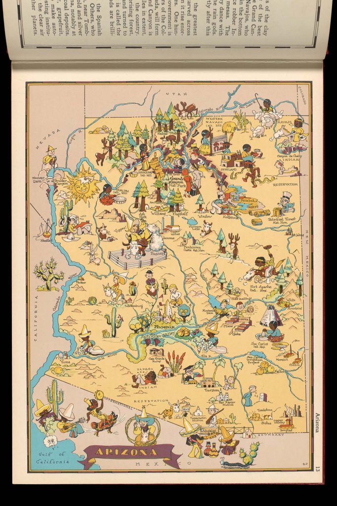
Fig. 11. Ruth Taylor, Arizona, in Frank and Ruth Taylor, Our USA: A Gay Geography (1935), from the Osher Map Library and Smith Center for Cartographic Education, University of Southern Maine (Gibb Collection). Click on image to see map in high-resolution.
The division between map and book, between supposedly scientific statement and discursive literature, so permeates scholarship today that it has become a deep schism. Examples are legion, from bibliographies that dutifully collate the letterpress signatures of each book without mentioning any of the maps they contained (e.g., Sitwell 1993; cf. McCorkle 2009), to the routine omission of inserted maps from modern reprintings, to the failure of Google and other digital scanning teams to fold out any plates in their digitized texts. Again, there are pragmatic reasons for these failings: many old books have had their maps and plates removed, so one needs to search hard for a still-complete book to use as a bibliographical exemplar; “fold-out,” as a press editor once remarked, is the “f-word” of modern printing, significantly increasing cost; most books have been digitized by automated systems that are designed for mass production of digital imagery and cannot cope with the cost of human intervention to recognize fold-outs and then reset the cameras to digitize them properly. At the same time, it must be recognized that solutions have not been found for these problems because maps and books are considered to be so fundamentally different.
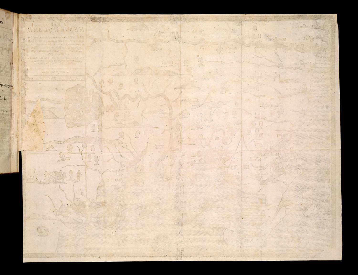
Fig. 12. Verso of William Hubbard, A Map of New-England, the “Wine Hills” map, from his Present State of New-England (1677b), from the Osher Map Library and Smith Center for Cartographic Education, University of Southern Maine (Osher Collection). Click on image to see map in high-resolution.
Digital technologies have been both a curse and a blessing. The proliferation of high-resolution imagery of maps in the digital collections of many libraries and archives means that it is easy to create virtual libraries of individual maps organized by region. But if care is taken, it is easy to preserve and communicate the physical context of the maps: for example, for a map folded up in a book, the map can be imaged as being clearly part of the book (as fig. 9), together with its verso (fig. 12) and the map as it is folded up within the book (fig. 13):
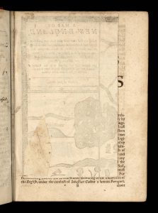
Fig. 13. William Hubbard, A Map of New-England, the “Wine Hills” map, folded up within his Present State of New-England (1677b), from the Osher Map Library and Smith Center for Cartographic Education, University of Southern Maine (Osher Collection). Click on image to see map in high-resolution.
Indeed, it is always desirable to image the verso of a map as well as the map per se on the recto of a page. And, while one is at it, include the binding, spine, and edges of the book so that the student can understand the nature of the work: ornate and expensive to cheap and nasty, and the continuum of quality in between.
These examples indicate some of the issues that have arisen from the treatment of maps. From a present-day perspective, this treatment can appear mistreatment, yet this judgment is a question of intellectual perspective. As our concepts and concerns continue to develop, in no small part thanks to The History of Cartography, our present-day treatment of maps will perhaps also come to be seen as inappropriate. But this is the nature of scholarship: today’s truths will perhaps be tomorrow’s controversies. Our intent is for the History to create a new foundation for the field for new generations of scholars.
Matthew Edney
Notes
n1. “Cette entreprise bien exécutée serait, en quelque sorte, une histoire de la géographie par les cartes, histoire faite par elle-même, c’est-à-dire par ses productions graphiques; elle serait donc la plus authentique et la plus sûre.”
n2. “Comme projection géométrique du sol, de ses accidens et de ses divisions, une carte est déjà un ouvrage scientifique entièrement distinct d’un livre. On peut ajouter même qu’il n’y a presque rien de commun entre l’un et l’autre. Ces deux ouvrages de l’esprit et de la main instruisent par des moyens qui diffèrent autant que leur nature propre et intime diffère. Si l’on a souvent ajouté des cartes à des livres, c’est que les lecteurs de ceux-ci ne pouvaient se passer de ce secours; tandis que dans un très grand nombre de cas, et même dans presque tous les cas, une carte peut se passer du secours d’un livre quelconque. On lit un livre, on perçoit pour ainsi dire une carte. Un livre se lit mot par mot, et page à page; une carte permet d’embrasser tout un sujet à la fois.”
n3. “Dira-t-on que les cartes doivent être considérées comme des livres, parce qu’elles peuvent être reliées comme eux, et réunies en volumes? Mais cette objection serait plus faible encore, ou même sans fondement; car ce n’est pas (il s’en faut) sous la forme d’atlas que les cartes sont de l’usage le plus commode. Il faut tout au contraire qu’elles soient isolées, placées sur des tablettes, ou bien roulées et suspendues à la manière anglaise.”
Works Cited
Adams, Randolph G. 1939. “William Hubbard’s ‘Narrative,’ 1677: A Bibliographical Study.” Papers of the Bibliographical Society of America 33:25–39.
Barber, Peter. 2020. “‘Context is everything…’: Ruminations on Developments in the History of Cartography since the 1970s and Their Consequences.” Imago Mundi 72, no. 2:131–47.
Baynton-Williams, Ashley. 2015. “Map Collecting in Europe.” In Cartography in the Twentieth Century, edited by Mark Monmonier, 248–51. Vol. 6 of The History of Cartography. Chicago: University of Chicago Press.
Beckett, John. 2007. Writing Local History. Manchester: Manchester University Press.
Bennett, Tony. 1995. The Birth of the Museum: History, Theory, Politics. London: Routledge.
Brückner, Martin. 2017. The Social Life of Maps in America, 1750–1860. Chapel Hill: University of North Carolina Press for the Omohundro Institute for Early American History and Culture.
Bus, Charles du. 1931. “Edme-François Jomard et les origines du cabinet des cartes (1777–1862).” Bulletin de la section de géographie de la comité des traveaux historiques 46:1–128.
Deane, Charles. 1887. “Notes on Hubbard’s Map of New England.” Proceedings of the Massachusetts Historical Society 2nd ser. 4:13–21.
Delano-Smith, Catherine. 2019. “Understanding the Gough Map: An Application of Physics, Chemistry and History.” On History. 12 August 2019. https://blog.history.ac.uk/2019/08/understanding-the-gough-map-the-application-of-physics-chemistry-and-history/.
Delano-Smith, Catherine, Peter Barber, Damien Bove, et al. 2017. “New Light on the Medieval Gough Map of Britain.” Imago Mundi 69, no. 1:1–36.
Duncan, Carol, and Alan Wallach. 1980. “The Universal Survey Museum.” Art History 3, no. 4:448–69.
Dym, Jordana, and Carla Lois. 2021. “Bound Images: Maps, Books, and Reading in Material and Digital Contexts.” Word & Image 37, no. 2:119–41.
Edney, Matthew H. 1997. Mapping an Empire: The Geographical Construction of British India, 1765–1843. Chicago: University of Chicago Press. Reprinted as New Delhi: Oxford University Press, 1999.
Edney, Matthew H., and Susan Cimburek. 2004. “Telling the Traumatic Truth: William Hubbard’s Narrative of King Philip’s War and his ‘Map of New-England’.” William & Mary Quarterly 3rd ser. 61, no. 2:317–48.
Gaimster, David, Sarah McCarthy, and Bernard Nurse. 2007. Making History: Antiquaries in Britain, 1707–2007. London: Royal Society of Arts.
Griffin, Dori. 2010. “Reading Maps, Writing Landscapes: Cartographic Illustration in Arizona, 1912–1962.” Ph.D. dissertation. Arizona State University.
Hornsby, Stephen J. 2017. Picturing America: The Golden Age of Pictorial Maps. Chicago: University of Chicago Press.
Hubbard, William. 1677a. A Narrative of the Troubles with the Indians in New-England, from the first planting thereof in the year 1607, to this present year 1677. But chiefly of the late Troubles in the two last years, 1675 and 1676. To which is added a Discourse about the Warre with the Pequods In the year 1637. Boston: printed by John Foster.
———. 1677b. The Present State of New-England. Being a Narrative of the Troubles with the Indians in New-England, from the first planting thereof in the year 1607, to this present year 1677: But chiefly of the late Troubles in the two last years 1675, and 1676. To which is added a Discourse about the War with the Pequods in the year 1637. London: Thomas Parkhurst.
Jomard, Edme François. 1831. Considérations sur l’objet et les avantages d’une collection spéciale consacrée aux cartes géographiques et aux diverses branches se la géographie. Paris: E. Duverger.
———. 1840. “Acquisitions du cabinet des cartes de la Bibliothèque Royale, pendant l’année 1840.” Bulletin de la société de géographie 2nd ser. 14:433–40.
———. 1841. “De l’utilité qu’on peut tirer de l’étude comparative des cartes géographiques.” Bulletin de la société de géographie 2nd ser. 15:184–94.
———. 1854–62. Les monuments de la géographie, ou recueil d’anciennes cartes européennes et orientales. Accompagnées de sphères terrestres et célestes, de mappemondes et tables cosmographiques, d’astrolabes et autre instruments d’observation, depuis les temps les plus reculés jusqu’à l’époque d’Ortélius et de Gérard Mercator, publiés en fac-simile de la grandeur des originaux. Paris: Duprat, Franck, Arthus Bertrand, Renouard, Gide et Baudry, and Delion.
———. 1879. Introduction à l’atlas des monuments de la géographie. Ed. E. Cortambert. Paris: A. Bertrand.
Laissus, Yves. 2004. Jomard, le dernier Égyptien: 1777–1862. Paris: Fayard.
Lange, Diana. 2020. An Atlas of the Himalayas by a 19th Century Tibetan Lama: A Journey of Discovery. Leiden: Brill.
McCorkle, Barbara B. 2009-11-02. “A Carto-Bibliography of the Maps in Eighteenth-Century British and American Geography Books.” http://hdl.handle.net/1808/5564 or http://kuscholarworks.ku.edu/dspace/handle/1808/5564.
Pedley, Mary Sponberg, and Matthew H. Edney. 2019. “Map Collecting in the Enlightenment.” In Cartography in the European Enlightenment, ed. Matthew H. Edney and Mary S. Pedley, 756–59. Vol. 4 of The History of Cartography. Chicago: University of Chicago Press.
Ratcliff, Jessica. 2019. “Hand-in-Hand with the Survey: Surveying and the Accumulation of Knowledge Capital at India House during the Napoleonic Wars.” Notes and Records of the Royal Society of London 73, no. 2:149–66.
Reynolds, David West. 1996. “Forma urbis Romae: The Severan Marble Plan and the Urban Form of Ancient Rome.” PhD dissertation. Classical Art and Archaeology. University of Michigan, Ann Arbor.
Richard, Hélène. 2010. “La création du département des cartes géographiques de la Bibliothèque royale.” In Naissances de la géographie moderne, 1760–1860: Lieux, pratiques, et formation des savoirs de l’espace, ed. Jean-Marc Besse, Hélène Blais, and Isabelle Surun, 245–61. Lyon: ENS Editions.
Santarém, Manuel Francisco de Barros e Sousa, Visconde de. 1842. Recherches sur la priorité de la découverte des pays situés sur la côte occidentale d’Afrique, au-dela du Cap Bojador, et sur les progrès de la science géographique, après les navigations des Portugais, au XVe siècle. Paris: Imprimerie de Ve Dondey-Dupré.
Sitwell, O. F. G. 1993. Four Centuries of Special Geography: An Annotated Guide to Books that Purport to Describe all the Countries in the World Published in English before 1888, with a Critical Introduction. Vancouver: University of British Columbia Press.
Talbert, Richard J. A. 2010. Rome’s World: The Peutinger Map Reconsidered. Cambridge: Cambridge University Press.
Taylor, Frank, and Ruth Taylor. 1935. Our USA: A Gay Geography. Boston: Little, Brown and Co.
Trimble, Jennifer. 2008. “Process and Transformation on the Severan Marble Plan of Rome.” In Cartography in Antiquity and the Middle Ages: Fresh Perspectives, New Methods, ed. Richard J. A. Talbert and Richard W. Unger, 67–97. Leiden: Brill.
Wertheim, Hans. 1931. Old Maps and Charts: A Short Guide for Collectors. Berlin: Das Bibliographikon. Originally published as Alte Karten: Ein Leitfaden für Sammler und Liebhaber (Berlin: Das Bibliographikon, 1931).
Wheat, James Clements, and Christian F. Brun. 1969. Maps and Charts Published in America before 1800: A Bibliography. New Haven, Conn.: Yale University Press. Rev. ed., London: Holland Press, 1978.
Woodward, David. 1967. “The Foster Woodcut Map Controversy: A Further Examination of the Evidence.” Imago Mundi 21:50–61.