Abstract: Cities pulse with life. People, information, and resources move through streets and neighborhoods, weaving the spatial structures of human-environment interactions in cities. While the proliferation of spatiotemporal data and advances in computational methods have significantly enhanced our ability to sense human activities and characterize geographic places, the power of spatial networks that organize our urban systems is still underutilized. Focusing on three missing pieces in contemporary urban social sensing: connected places, invisible flows, and unknown mechanisms, Di’s talk will discuss how GeoAI and network-informed spatial analytics and modeling can reveal the structural relationships among people, places, and environments that give rise to complex spatiotemporal phenomena in cities.
Bio: Dr. Di Zhu is an Assistant Professor of GIScience in the Department of Geography, Environment, and Society at the University of Minnesota, Twin Cities (UMN) and the director of Geospatial Data Intelligence (GeoDI) Lab. He holds a Ph.D. in Cartology and GIScience, a B.S. in GIS, and a dual B.Ec. in Economics all from Peking University. Di’s research bridges Spatial Statistics, Geospatial Artificial Intelligence (GeoAI), and Spatiotemporal Social Sensing, focusing on the human-environment systems within urban socioeconomics, human mobility, transportation, population, etc. Beyond the main appointment at UMN, Dr. Zhu is a faculty member of the Minnesota Population Center, a CTS scholar at the Center for Transportation Studies, an executive committee member of the MGIS program, and an affiliated faculty at the Data Science Initiatives of UMN. Di was a visiting lecturer at SpaceTimeLab, University College London before joining UMN. He has published in top venues such as IJGIS, AAAG, TGIS, GeoInformatica, EPB, Scientific Data, ISPRS JPRS, TPAMI, ACM SIGKDD. He served as a panelist or reviewer for NSF CISE, HEGS, MMS and ES programs. He was the BOD member of CPGIS during 2023-2025. He served as a chair, local chair, or PC member for conferences, workshops, and sessions such as ACM SIGSPATIAL, AAG, GISRUK, GeoInformatics. He has won academic accolades such as the Rising Star Award of College GIS Forum in China, Top 20 WGDC 2022 Global Young Scientist Award, Early Career Award of GIS Research of the United Kingdom, Distinction of Doctoral Thesis of Peking University, etc. Di teaches in GIScience, spatial analysis, GeoAI, and spatial networks.
Congratulations to our GeoDS lab PhD student Qianheng Zhang, who just won the 1st place in the “Best Student Honors Paper Competition” of the Geographic Information Science and Systems Specialty Group (GISS-SG) at AAG 2026!
2026 AAG Annual Meeting, San Francisco, California, March 17-21, 2026
Lead Organizers:
Yingjie Hu, University at Buffalo
Song Gao, University of Wisconsin, Madison
Wenwen Li, Arizona State University
Budhu Bhaduri, Oak Ridge National Laboratory
Orhun Aydin, Saint Louis University
Shawn Newsam, University of California, Merced
Samantha T. Arundel, United States Geological Survey
Gengchen Mai, University of Texas Austin
Krzysztof Janowicz, University of Vienna
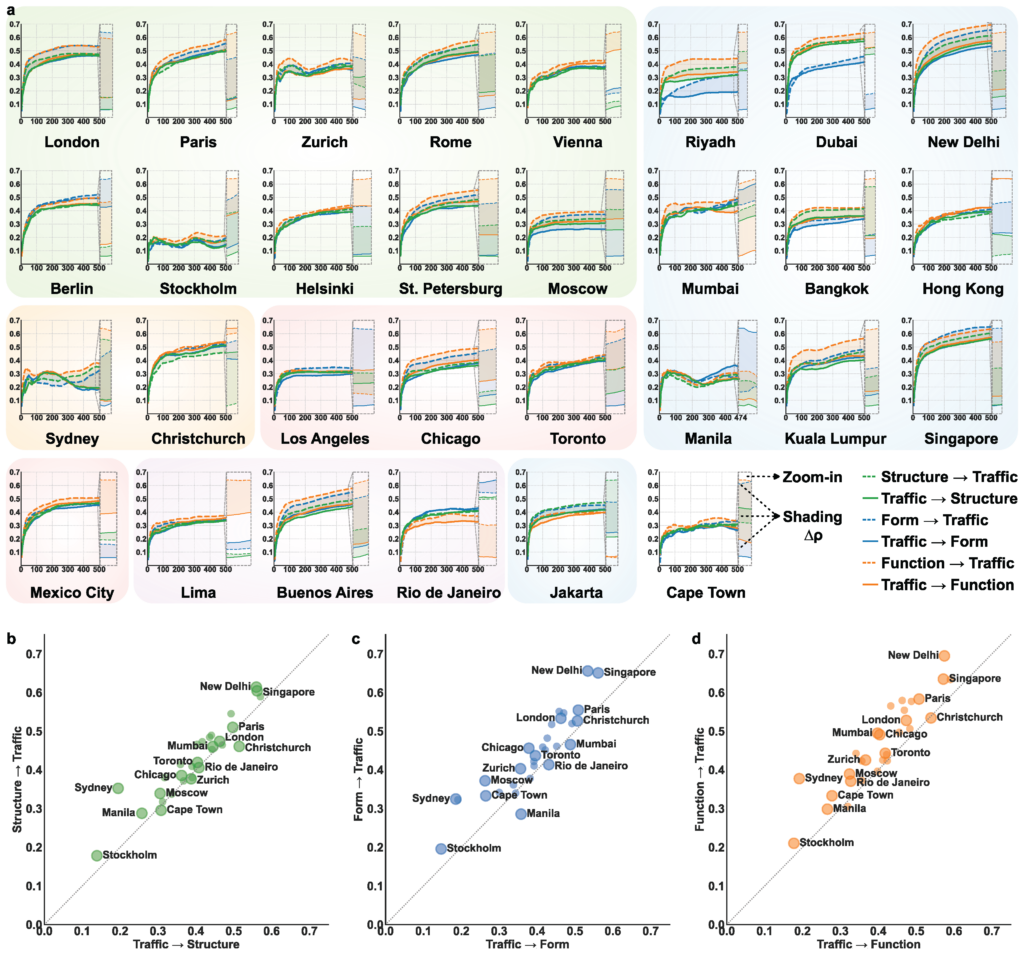
The field of GeoAI is advancing rapidly. New AI models, such as vision foundation models, large language models, and multimodal foundation models, provide new possibilities for developing geospatial solutions. Spatial principles, such as Tobler’s First Law, are being incorporated into AI architectures to create spatially explicit models, while explainable GeoAI methods are being explored to improve the interpretability of results. From an application perspective, GeoAI research continues playing positive roles in addressing societal challenges and helping achieve sustainable development goals. Examples include improving individual and population health, enhancing community resilience to disasters, predicting spatiotemporal traffic flows, forecasting climate change impacts on ecosystems, building smart and connected communities and cities, and supporting humanitarian mapping and policymaking. At the same time, the rapid advancement of GeoAI also carries risks, such as the increased opaqueness of large AI models and the environmental costs of training them. How can we continue leveraging GeoAI for making positive impacts while mitigating potential risks? The 2026 AAG GeoAI Symposium aims to bring together geographers, GIScientists, remote sensing scientists, computer scientists, health researchers, urban planners, transportation professionals, disaster response experts, ecologists, earth system scientists, stakeholders, and others to share recent GeoAI research, discuss challenges, and chart the way forward for the coming years.
GeoAI and Deep Learning Symposium: AI and Machine Learning Applications in Human Mobility Analytics (Paper session; Contact: Pingping Wang, Texas State University (pingpingwang@txstate.edu). Co-organizers: Yihong Yuan, Texas State University, Yi Qiang, University of South Florida, and Somayeh Dodge, University of California Santa Barbara)
GeoAI and Deep Learning Symposium: Social Sensing and GeoAI for Public Health (Paper session; Contact: Mingzheng Yang, Texas A&M University (ymz2020@tamu.edu). Co-organizers: Xiao Huang, Emory University, Lei Zou, Texas A&M University)
GeoAI and Deep Learning Symposium: Advances and Potential Risks in GeoAI Research (Panel session; Contact: Yingjie Hu, University at Buffalo (yhu42@buffalo.edu); Panelists: Kathleen Stewart, University of Maryland College Park; Wenwen Li, Arizona State University; Peter Kedron, University of California Santa Barbara; Song Gao, University of Wisconsin-Madison; Budhu Bhaduri, Oak Ridge National Lab)
GeoAI and Deep Learning Symposium: Geosimulation and Its Emerging Directions with AI (Paper session; Contact: Jeon-Young Kang, Kyung Hee University (geokang@khu.ac.kr); Co-organizers: Boyu Wang, University at Buffalo; Fuzhen Yin, University of Colorado Colorado Springs)
GeoAI and Deep Learning Symposium: AI for Earth Observation (Paper session; Contact: Tang Sui, University of Wisconsin-Madison (tsui5@wisc.edu); Co-organizers: Bo Peng, Amazon; Bandana Kar, National Renewable Energy Laboratory; Qunying Huang, University of Wisconsin-Madison; Zhenlong li, Pennsylvania State University)
GeoAI and Deep Learning Symposium: UrbanAI for Sustainable, Climate-Resilient Environments (Paper session; Contact: Steffen Knoblauch, Heidelberg University (steffen.knoblauch@uni-heidelberg.de) ; Co-organizers: Hao Li, National University of Singapore; Gengchen Mai, The University of Texas at Austin; Yingjie Hu, University at Buffalo; Wenwen Li, Arizona State University)
GeoAI and Deep Learning Symposium: AI Ethics and Spatial Equity (Paper session; Contact: Hongyu Zhang, University of Massachusetts Amherst (honzhang@umass.edu) ; Co-organizers: Yue Lin, University of Illinois Urbana-Champaign; Bing Zhou, University of Tennessee Knoxville; Yuhao Kang The University of Texas at Austin)
GeoAI and Deep Learning Symposium: GeoAI for Disaster Resilience (Paper session; Contact: Bing Zhou, University of Tennessee, Knoxville (bzhou11@tennessee.edu) ; Co-organizers: Lei Zou, Texas A&M University; Yifan Yang, Texas A&M University; Yingjie Hu, University at Buffalo; Qunying Huang, University of Wisconsin-Madison; Marcela Suárez, Penn State University, Yi Qiang, University of South Florida; Manzhu Yu, Penn State University; Morteza Karimzadeh, University of Colorado Boulder)
GeoAI and Deep Learning Symposium: GeoAI for Disaster Resilience II (Paper session; In-person session; Contact: Xiao Chen (xchen414@asu.edu), Arizona State University, Chenyan Lu, Arizona State University; Wenwen Li, Arizona State University)
GeoAI and Deep Learning Symposium: Spatial Representation Learning from Raster and Vector Data (Panel session; Contact: Steffen Knoblauch, Heidelberg University (steffen.knoblauch@uni-heidelberg.de) ; Panelists: Wenwen Li, Arizona State University; Song Gao, University of Wisconsin-Madison; Gengchen Mai, University of Texas at Austin)
GeoAI and Deep Learning Symposium: Advancing Sustainable Geospatial Knowledge through Spatial Reasoning and Open Science (Paper session; Contact: Yanan Wu, University of Central Arkansas (ywu@uca.edu) ; Co-organizers: Chengbin Deng, University of Oklahoma; Tao Hu, Oklahoma State University; Yalin Yang West Virginia University Press)
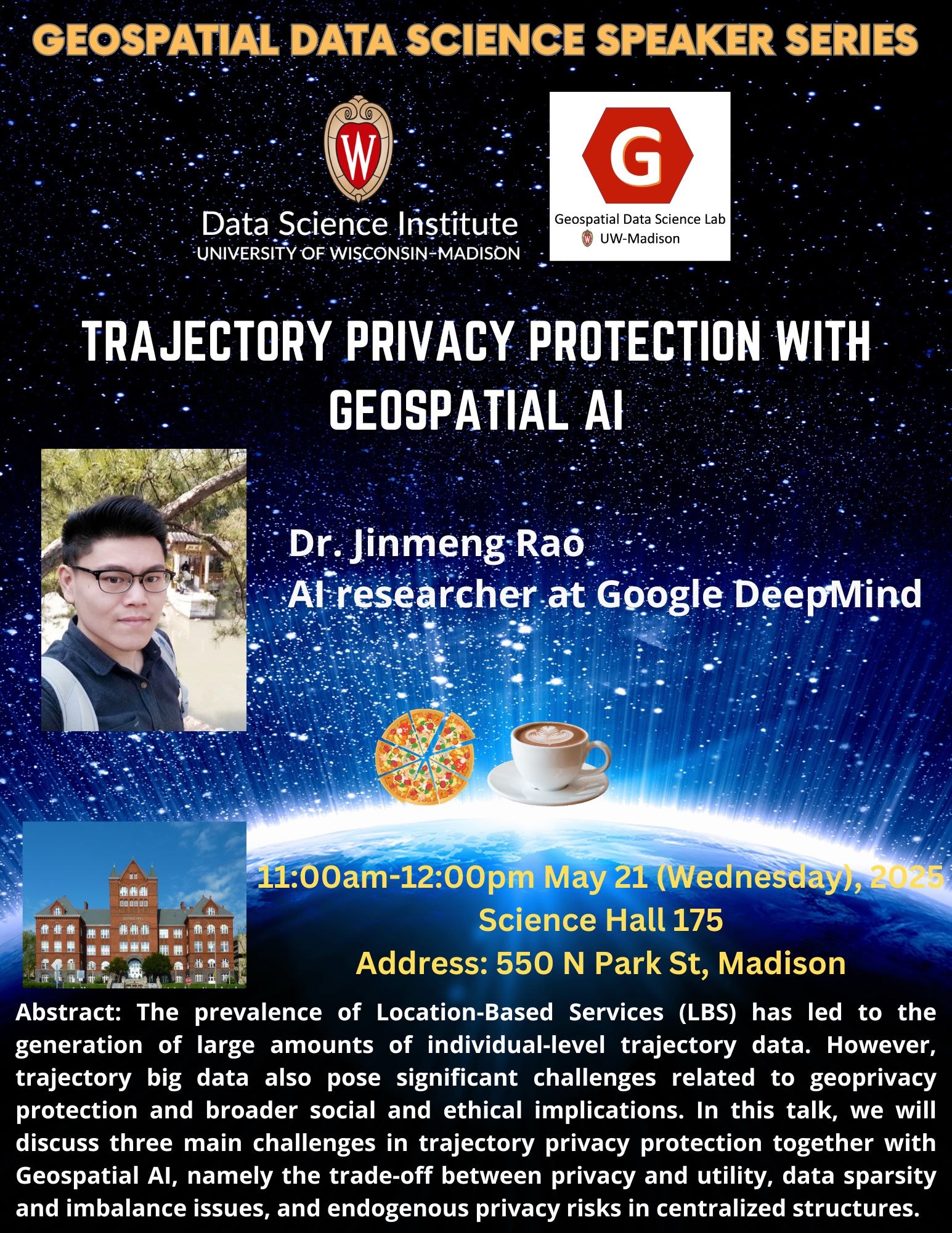
GeoAI and Deep Learning Symposium: The Convergence of Generative AI and GIScience: Challenges and Opportunities (Panel session; Contact: Zhenlong Li, Penn State University (zhenlong@psu.edu); Huan Ning, Emory University; Song Gao, University of Wisconsin-Madison; Arif Masrur, ESRI; Temitope Akinboyewa, Penn State University; Ruixiang Liu, Penn State University; Ali Khosravi Kazazi, Penn State University; Wenwen Li, Arizona State University; Jinmeng Rao, Google DeepMind; Budhendra Bhaduri, Oak Ridge National Laboratory; Samantha T. Arundele, USGS)
GeoAI and Deep Learning Symposium: The Convergence of Generative AI and GIScience: Research Agenda Towards Autonomous GIS (Panel session; Contact: Zhenlong Li, Penn State University (zhenlong@psu.edu); Co-organizers: Huan Ning, Emory University; Song Gao, University of Wisconsin-Madison; Arif Masrur, ESRI; Temitope Akinboyewa, Penn State University; Ruixiang Liu, Penn State University; Ali Khosravi Kazazi, Penn State University; Wenwen Li, Arizona State University; Jinmeng Rao, Google DeepMind; Budhendra Bhaduri, Oak Ridge National Laboratory; Samantha T. Arundele, USGS)
GeoAI and Deep Learning Symposium: The Convergence of Generative AI and GIScience: Autonomous AI Agents Development for Geospatial Tasks (Paper session; Contact: Zhenlong Li, Penn State University (zhenlong@psu.edu); Co-organizers: Huan Ning, Emory University; Song Gao, University of Wisconsin-Madison; Arif Masrur, ESRI; Temitope Akinboyewa, Penn State University; Ruixiang Liu, Penn State University; Ali Khosravi Kazazi, Penn State University; Wenwen Li, Arizona State University; Jinmeng Rao, Google DeepMind; Budhendra Bhaduri, Oak Ridge National Laboratory; Samantha T. Arundele, USGS)
GeoAI and Deep Learning Symposium: The Convergence of Generative AI and GIScience: Framework, Foundation Models, Standards, and Infrastructure (Paper session; Contact: Zhenlong Li, Penn State University (zhenlong@psu.edu); Co-organizers: Huan Ning, Emory University; Song Gao, University of Wisconsin-Madison; Arif Masrur, ESRI; Temitope Akinboyewa, Penn State University; Ruixiang Liu, Penn State University; Ali Khosravi Kazazi, Penn State University; Wenwen Li, Arizona State University; Jinmeng Rao, Google DeepMind; Budhendra Bhaduri, Oak Ridge National Laboratory; Samantha T. Arundele, USGS)
GeoAI and Deep Learning Symposium: The Convergence of Generative AI and GIScience: Society Impacts, Education and Ethical Considerations (Paper session; Contact: Zhenlong Li, Penn State University (zhenlong@psu.edu); Co-organizers: Huan Ning, Emory University; Song Gao, University of Wisconsin-Madison; Arif Masrur, ESRI; Temitope Akinboyewa, Penn State University; Ruixiang Liu, Penn State University; Ali Khosravi Kazazi, Penn State University; Wenwen Li, Arizona State University; Jinmeng Rao, Google DeepMind; Budhendra Bhaduri, Oak Ridge National Laboratory; Samantha T. Arundele, USGS)
GeoAI and Deep Learning Symposium: The Convergence of Generative AI and GIScience: Domain Applications and Use Cases (Paper session; Contact: Zhenlong Li, Penn State University (zhenlong@psu.edu); Co-organizers: Huan Ning, Emory University; Song Gao, University of Wisconsin-Madison; Arif Masrur, ESRI; Temitope Akinboyewa, Penn State University; Ruixiang Liu, Penn State University; Ali Khosravi Kazazi, Penn State University; Wenwen Li, Arizona State University; Jinmeng Rao, Google DeepMind; Budhendra Bhaduri, Oak Ridge National Laboratory; Samantha T. Arundele, USGS)
GeoAI and Deep Learning Symposium: The Convergence of Generative AI and GIScience: Benchmarking, Fine Tuning, and Evaluation (Paper session; Contact: Zhenlong Li, Penn State University (zhenlong@psu.edu); Co-organizers: Huan Ning, Emory University; Song Gao, University of Wisconsin-Madison; Arif Masrur, ESRI; Temitope Akinboyewa, Penn State University; Ruixiang Liu, Penn State University; Ali Khosravi Kazazi, Penn State University; Wenwen Li, Arizona State University; Jinmeng Rao, Google DeepMind; Budhendra Bhaduri, Oak Ridge National Laboratory; Samantha T. Arundele, USGS)
GeoAI and Deep Learning Symposium: GeoAI and the Future of African Urbanism: (Paper session; Contact: Isaac Quaye, Temple University (isaac.quaye@temple.edu), Co-organizers: Oforiwaa Pee Agyei-Boakye, University of Minnesota Twin Cities)
GeoAI and Deep Learning Symposium: Spatially Explicit Machine Learning and Artificial Intelligence: (Paper session; Contact: Gengchen Mai, University of Texas at Austin (gengchen.mai@austin.utexas.edu) ; Co-organizers: Angela Yao, University of Georgia; Zhangyu Wang, University of Maine)
GeoAI and Deep Learning Symposium: Geographic Biases and Transferability in GeoAI (Paper session; Contact: Zhiyong Zhou, University of Wisconsin–Madison, zhiyong.zhou@wisc.edu; Co-organizers: Song Gao, University of Wisconsin–Madison)
GeoAI and Deep Learning Symposium: GeoAI for Spatial Analytics and Modeling (Paper session; Contact: Di Zhu, University of Minnesota (dizhu@umn.edu) ; Co-organizers: Guofeng Cao, University of Colorado, Boulder; Song Gao, University of Wisconsin, Madison; Peng Luo, Massachusetts Institute of Technology)
GeoAI and Deep Learning Symposium: GeoAI for Resilient Urban Design for Natural Hazards and Human-Made Disasters (Paper session; Contact: Orhun Aydin, Saint Louis University (orhun.aydin@slu.edu) ; Co-organizer: Yingjie Hu, University at Buffalo)
This symposium is sponsored by: AAG GISS, SAM, and CISG specialty groups.
Title: A New Era of Spatial Intelligence with GeoAI
Abstract: Drawing on ongoing GeoAI initiatives spanning public health, education, and urban analytics, this talk advances a vision of GeoAI as a next-generation paradigm for intelligent spatial decision-making. Through real-world case studies, including advanced computer vision integrated with urban visual analytics, GeoAI-enabled malaria intervention in East Africa, and Generative AI–supported geography education, the presentation illustrates how high-resolution satellite imagery, street-view data, foundation models, and community-engaged frameworks can transform geospatial information into actionable intelligence. It also critically examines emerging challenges, including data bias and quality, digital divides, geo-hallucinations, and AI–human perceptual mismatches. By coupling theory-aware modeling with responsible cyberinfrastructure and human-in-the-loop design, GeoAI can move beyond automation toward equitable, explainable, and socially grounded spatial decision intelligence in a rapidly evolving world.
Bio: Dr. Xiao Huang is an Assistant Professor in the Department of Environmental Sciences at Emory University. His research spans human–environment interactions, computational social science, urban informatics, GeoAI, and disaster remote sensing, with a strong focus on integrating artificial intelligence and geospatial technologies for societal impact. He has authored more than 240 peer-reviewed journal articles and over 20 book chapters, edited five books, and received more than 7,000 citations on Google Scholar. He is recognized among the World’s Top 2% Scientists by Stanford/Elsevier. Dr. Huang serves as Associate Editor for Computational Urban Science and the Journal of Remote Sensing, and sits on the editorial boards of several leading journals. His work has been featured by Nature News, NASA, NBC, and Fox. He has secured competitive funding from NSF, NASA, the Bill & Melinda Gates Foundation, and the National Academies, and is the recipient of the 2026 AAG Glenda Laws Award.
Title: Learning Earth’s Water Extremes: Geo-Foundation Models for Flood and Cryosphere Monitoring
Abstract: Monitoring floods, glaciers, and glacial lakes is of broad interest to the scientific community due to their direct impact on human lives, infrastructure, and freshwater availability. Recent advances in remote sensing and deep learning have enabled fast, automated, and reliable mapping of these Earth surface processes. However, the widespread application of deep learning remains limited by the scarcity of labeled data across diverse geographic regions. In this context, recent developments in geo-foundation models offer significant potential to generate robust and transferable maps in data-scarce settings by leveraging large-scale pretraining of model encoders. In this talk, I will present case studies on floods, glaciers, and glacial lakes using multi-source remote sensing data and geo-foundation models. Our experiments aim to inform end users about optimal model selection strategies under varying data availability scenarios. Additionally, I will explore the emerging potential of integrating vision models with large language models to further advance Earth observation capabilities. Overall, these examples demonstrate improved monitoring of two critical Earth system components—the cryosphere and the hydrosphere—and contribute to a better understanding of associated hazards and freshwater resources.
Bio: Dr. Saurabh Kaushik received the Ph.D. degree through a bi-national program between the Academy of Scientific and Innovative Research (AcSIR), India, and the German Aerospace Center (DLR), Germany. He is currently a Postdoctoral Research Associate at the University of Wisconsin-Madison, working on NSF and NASA funded flood mapping project. His research lies at the intersection of computer vision, remote sensing, and Earth observation, with a focus on glacial lakes, floods, glaciers, and water-resource risk assessment. His work aims to develop scalable, reliable Earth observation solutions for long-term environmental monitoring. To learn more about his publications and projects see: https://sk-2103.github.io/
Title: Spatio-Temporal Data Mining: From Deep Learning to Foundation Models
Abstract: Spatio-temporal (ST) data, which integrates spatial (location-based) and temporal (time-based) information, is the key to improving many real-world applications with high social impacts, such as transportation, logistics, climate, and energy. This talk presents the evolution of spatio-temporal AI, transiting from task-specific deep learning models to the emerging paradigm of foundation models. I will highlight my research progress in modeling human mobility behavior and logistics, specifically focusing on methodologies such as DeepRoute , Graph2Route , and DRL4Route for route prediction and DiffSTG for probabilistic graph forecasting. Furthermore, I will introduce LaDe, the first comprehensive last-mile delivery dataset from industry. Of particular focus in this talk is the recent progress in Spatio-Temporal Foundation Models (STFMs), including the Taxonomy of current STFM and future research opportunities.
Bio: Haomin Wen is postdoctoral researcher at CMU Data Analytics Techniques Algorithms (DATA) Lab. He was a joint PhD at National University of Singapore, received his Ph.D. from INSIS Lab, Beijing Jiaotong university. Dr. Wen’s research mainly focuses on spatial-temporal data mining, human mobility learning to understand the patterns of human’s movements especially in the logistics system. His articles have been published in top journals and conferences, including TKDE, TITS, KDD, ACM SIGSPATIAL, AAAI, etc. He is the founder of Overleaf Copilot. He serves as a reviewer or for the program committee for various journals and conferences, including KDD, IJCAI, ICML, etc.
Understanding the interaction between complex urban environments and human mobility flow patterns underpins adaptive transport systems, resilient communities, and sustainable urban developments, yet inter-regional origin-destination mobility flow information from traditional surveys are costly to update. The satellite imagery offers up-to-date information on urban sensing and opens avenues to examine urban morphology-mobility dynamics. This study develops a deep learning model, Imagery2Flow for predicting fine-grained human mobility flows in urban areas using 10 to 30-meter medium resolution satellite imagery in a timely and low-cost manner. Extensive experiments demonstrate good performance and flexible spatial-temporal generalizability on the top-10 largest metropolitan statistical areas of the United States. Through exploring the spatial heterogeneous effects, we investigate the urban factors (centrality and compactness) influencing human movement flow distributions, enhancing our comprehension of their interactions. The spatial transferability of Imagery2Flow helps reduce regional inequality by informing decisions in data-poor regions, learning from data-rich ones. Interestingly, the typologies of urban sprawl can help explain the cross-city model generalization capability. The temporal transferability proves that human dynamics of cities and the process of urbanization can be well captured from the observed built environment by remote sensing.
Title: GeoAI-enabled multi-scale cartography: progress and a research agenda
Abstract:
Multi-scale spatial representation is a crucial mechanism for describing facts about the real world and for managing and communicating spatial data efficiently and effectively. To enable such multi-scale spatial representation, map generalization has thus been developed. The advances of GeoAI, which focus on spatially oriented deep learning and process understanding with AI techniques, have brought about a new paradigm for map generalization. In this talk, I will present the latest research progress on GeoAI-enabled map generalization supported by the Swiss National Science Foundation (SNSF). This work spans the full GeoAI workflow: from geospatial problem formulation and spatial data modeling to spatially aware deep learning architectures and explainable AI techniques. Building on these developments, I will also discuss key technical challenges and research opportunities for applying GeoAI to multi-scale cartography, with the aim of informing and inspiring future innovation in the field.
Short bio:
Dr. Zhiyong Zhou is a Swiss postdoctoral research fellow and a visiting scholar at the GeoDS Lab, University of Wisconsin-Madison, which is supported by the SNSF Postdoc.Mobility Fellowship. Prior that, he was a postdoc at the Department of Geography, University of Zurich, Switzerland. He holds a Ph.D. in Geography/Earth System Science from the University of Zurich, as well as an M.E. degree and a B.E. degree with Honors from China University of Geosciences (Wuhan). His research focuses on human-centered geospatial AI. He primarily investigates human–space interactions and develop human-adaptive, spatially explicit techniques for spatial data generalization, smart mobility, and sustainable built environments. Additionally, he serves as vice-chair of the ICA Commission on Location-Based Services.
Enhancing AI’s Geospatial Intelligence: Multimodality, Spatial-Explicitness, and Explainability
Abstract
This talk focuses on three perspectives (i.e., data, methodology, and explainability) to discuss how we can enhance geospatial intelligence of AI models, a core question in the development of GeoAI. First, I will introduce a multimodal learning framework that fuses remote sensing imagery, LiDAR, and text/POIs. The framework consists of CityVerse, a curated geospatial multimodal benchmark, and CLIP4Geo, a geospatial vision-language model that aligns geographic coordinates, textual descriptions, and visual features to support various urban analytical tasks, highlighting the value of dataset quality over sheer scale. Next, I will present the design of spatially explicit graph neural networks that integrate mobility (OD flows) with geographic contiguity, and showcase their performance in epidemic forecasting. Results reveal city-specific regimes where hybrid mobility-contiguity graphs can outperform either alone. Finally, I will present Semantic4Safety, an explainable GeoAI pipeline for urban road safety: zero-shot semantic segmentation constructs interpretable streetscape indicators from street view images, coupled with XGBoost, SHAP, and causal effect estimation on geo-located incidents to yield actionable, type-specific risk factors. By demonstrating these perspectives and case studies, this talk aims to facilitate the roadmap for developing Geo-Foundation Models in the future.
Short Bio
Dr. Meiliu Wu is a Lecturer (Assistant Professor) in Geospatial Data Science at the University of Glasgow (UoG), where she directs the new MSc program in Geospatial Data Science and AI and leads the GIFTS Lab (Geospatial Intelligence for Future Technology and Sustainability Lab). She earned her PhD in Geography from the University of Wisconsin-Madison in May 2024 and joined UoG in August 2024. Dr. Wu’s research interests include GIScience, geospatial AI (GeoAI), debiasing, urban analytics, and environmental sciences, with her work featured in leading journals/conferences and funded by UKRI and the Alan Turing Institution. She is a Fellow of Royal Geographical Society with IBG, serving as a Committee Executive Member of GIScience Research Group.
Congratulations to our lab member Qianheng ZHANG (together with Geography PhD student Yanbing Chen) jointly won the 27th Annual Student Dynamic Map Competition at the North American Cartographic Information Society (NACIS) 2025 annual conference.
NACIS recognizes the importance of digital and dynamic interactive mapping in Cartography by hosting this competition.The winning team project is the Lyriscape of Cantopop (Hong Kong Music Atlas):
GeoDS Lab is excited to welcome two outstanding postdoc research fellows Dr. Ardiantiono and Dr. Zhiyong Zhou joining our group this Fall!
Ardiantiono, University Distinguished Research Fellow, RISE Initiative
I am a conservation scientist focused on advancing evidence-based conservation in tropical ecosystems. I’ve been fortunate to work with incredible species—from tigers and elephants to Komodo dragons and hornbills. My work centers on optimizing biodiversity monitoring in human-dominated landscapes, fostering human–wildlife coexistence, and strengthening community-based conservation. Working with Prof. Zuzana Burivalova from Sound Forest Lab and Prof. Song Gao from Geospatial Data Science Lab, I’m developing an AI-based framework to integrate camera trap, acoustic, and eDNA data for monitoring the biodiversity benefits of Natural Climate Solutions. I currently serve as President of the Society for Conservation Biology Indonesia (2023-2025) and as an Associate Editor for the Journal of Applied Ecology.
I am a postdoctoral research fellow supported by the Swiss National Science Foundation (SNSF) through the Postdoc.Mobility Fellowship. Prior to joining the GeoDS Lab, I was a postdoc at the Department of Geography, University of Zurich, Switzerland. I hold a Ph.D. in Geography/Earth System Science from the University of Zurich, as well as an M.E. degree and a B.E. degree with Honors from China University of Geosciences (Wuhan). My research focuses on human-centered geospatial AI. I primarily investigate human–space interactions and develop human-adaptive, spatially explicit techniques for spatial data generalization, smart mobility, and sustainable built environments. Additionally, I serve as vice-chair of the ICA Commission on Location-Based Services.
Title: Trajectory Privacy Protection with Geospatial AI
Abstract: The prevalence of Location-Based Services (LBS) has led to the generation of large amounts of individual-level trajectory data, which offers opportunities to study human mobility patterns, human-environment interactions, disaster responses, and public health issues. However, trajectory big data also pose significant challenges related to geoprivacy protection and broader social and ethical implications. In this talk, we will discuss three main challenges in trajectory privacy protection, namely the trade-off between privacy and utility, data sparsity and imbalance issues, and endogenous privacy risks in centralized structures. We will also introduce some of our recent work to demonstrate the potential of Geospatial AI in addressing these challenges in trajectory privacy protection.
Bio: Dr. Jinmeng Rao is an AI researcher at Google DeepMind. He was an AI researcher at Google[X]. He got his MS in Computer Sciences and PhD in Geography at UW-Madison supervised by Prof. Song Gao. He holds a M.S. and B.S. in Cartography and GIS from Wuhan University. His main research interest is Geospatial AI and geoprivacy. His articles have been published in top journals and conferences, including IJGIS, TGIS, GIScience, ACM SIGSPATIAL, ACM SIGIR, AAAI, etc. He serves as a reviewer or for the program committee for various journals and conferences, including IJGIS, Annals of GIS, TGIS, JAG, Computers & Geosciences, NeurIPS, ACL, etc. He received the 2024 AAG William L. Garrison Award for Best Dissertation in Computational Geography.
Title: Human-centered GeoAI in the era of Generative AI: Perceptions and Creativity
Abstract: The emergence of Generative AI offers numerous opportunities to benefit geospatial intelligence, enabling novel ways to advance our knowledge of human perceptions and creativity. In Dr. Kang’s talk, he will explore the impact of Generative AI on geospatial analytics through two key perspectives. First, he will discuss how a Soundscape-to-Image model could translate and visualize human perceptions of visual and acoustic environments. Second, he will illustrate how generative AI, through the process of data-style separation, can produce not only accurate but also visually appealing maps that adhere to ethical standards in cartography. His talk will delve into the transformative potential of Generative AI in the development of Human-centered GeoAI.
Bio: Dr. Yuhao Kang is a tenure-track Assistant Professor, directing the GISense Lab at the Department of Geography and the Environment, The University of Texas at Austin. He was a postdoctoral researcher at the MIT SENSEable City Lab, received his Ph.D. from the GeoDS Lab, University of Wisconsin-Madison, and obtained his bachelor’s degree from Wuhan University. Before joining UT-Austin, he had working experience at the University of South Carolina, Google X, and MoBike. He was the founder of the non-profit educational organization GISphere that promotes global GIS education. Dr. Kang’s research mainly focuses on Human-centered Geospatial Data Science to understand human experience at place and develop ethical and responsible geospatial artificial intelligence (GeoAI) approaches. He was the recipient of the Waldo-Tobler Young Researcher Award by the Austrian Academy of Sciences, CaGIS Rising Award, CPGIS Education Excellence Award, etc.
Title: Spatial Representation Learning: What, How, and Why
Abstract: Spatial representation learning (SRL) aims at learning general-purpose neural network representations from various types of spatial data (e.g., points, polylines, polygons, networks, images, etc.) in their native formats. Learning good spatial representations is a fundamental problem for various downstream applications such as species distribution modeling, weather forecasting, trajectory generation, geographic question answering, etc. In this presentation, we will discuss several recent works from UT SEAI Lab about spatial representation, including various location encoding models (Space2Vec and Sphere2Vec), an SRL deep learning framework (TorchSpatial), and a SRL-powered geo-foundation model (GAIR). We will discuss 1) WHAT is location representation learning? 2) HOW to develop location representation learning models? and 3) WHY do we need them?
Bio: Dr. Gengchen Mai is currently a Tenure-Track Assistant Professor at the Department of Geography and the Environment, University of Texas at Austin. He got his Ph.D. in GIScience from UCSB Geography. Before becoming a faculty, he was a Postdoc at Stanford Computer Science. Before joining UT, he was an Assistant Professor at the University of Georgia. Dr. Mai’s research is Spatially Explicit Artificial Intelligence, Geo-Foundation Models, Geographic Knowledge Graphs, etc. Dr. Mai’s work has been published not only in many top geography/GIScience/Remote Sensing journals but also in many ML/AI conferences such as NeurIPS, ICML, ICLR, ACM SIGIR, ACM SIGSPATIAL, etc. He is the recipient of many prestigious awards including AAG 2021 Dissertation Research Grants, AAG 2022 William L. Garrison Award for Best Dissertation in Computational Geography, AAG 2023 J. Warren Nystrom Dissertation Award, Top 10 WGDC 2022 Global Young Scientist Award, the Jack and Laura Dangermond Graduate Fellowship, UT MGCE Fellowship, 2025 Geospatial Rising Star Award, etc. He is currently the registration chair of ACM SIGSPATIAL 2025, vice chair of AAG GISS Specialty Group, and PC member for NeurIPS, ICML, ICLR, WWW, AISTATS, ACM SIGIR, ACM SIGSPATIAL, GIScience, etc.
Professor Song Gao was named the Clarivate’s Top 1% Highly Cited Researchers 2024, which marked his continuous third time (2022-2024) making onto the lists.
There are 15 researchers at UW-Madison to have earned this impressive distinction this year.
FROM CLARIVATE: Each researcher selected has authored multiple ESI Highly Cited Papers™ which rank in the top 1% by citations for their field(s) and publication year in the Web of Science™ over the past decade. However, citation activity is not the sole selection indicator. This list, based on citation activity is then refined using qualitative analysis and expert judgment as we observe for evidence of community-wide recognition from an international and wide-ranging network of citing authors. Of the world’s population of scientists and social scientists, So the Highly Cited Researchers are 1 in 1,000.
The Thirteenth International Conference on Geographic Information Science (GIScience 2025) will be held in Christchurch, New Zealand, on 26-29 August 2025, hosted by the University of Canterbury in collaboration with the GIScience academic research community across New Zealand. GIScience 2025 is the flagship conference in geographic information science and continues the highly successful conference series which started in 2000.
The conference regularly attracts over 250 international participants from academia, industry, and government to discuss and advance the state-of-the-art in geographic information science. August 26 is dedicated to Workshops and Tutorials. The main conference runs from August 27 to 29 and includes a single refereed paper track and an abstract track for posters and demo submissions. GIScience research spans the gamut of interrelated discovery activities related to geographic information from the invention of new computational instruments, the gathering of data via observation or experimentation, and discovery of descriptive generalizations patterns in data through to the creation of explanatory theories and the testing of theories. The GIScience conference series seeks submissions that make fundamental advances to the field through this multifaceted process.
GIScience 2025 welcomes papers, posters and demos covering emerging topics and fundamental research findings across all sectors of geographic information science, including (but not limited to) the role of geographic information in geography, computer science, engineering, information science, linguistics, mathematics, cognitive science, philosophy, psychology, social science, and geostatistics. We welcome participation from community members sharing work at various stages of development, including position pieces, works in progress, as well as full papers for inclusion in the conference proceedings.
Samantha T. Arundel, United States Geological Survey
Gengchen Mai, University of Texas Austin
Krzysztof Janowicz, University of Vienna
The field of GeoAI is advancing at an astonishing speed. We are excited to witness the significant growth of GeoAI in terms of its methods, its diverse geospatial applications, and its increasing societal impacts. For example, GeoAI has been applied to advance our understanding of environmental and climate change on the earth, improve individual and population health, enhance community resilience in natural disasters, strengthen smart and connected communities, more accurately predict spatiotemporal traffic flows, support humanitarian mapping and policymaking, and more. From the perspective of methodological development, we have observed a paradigm shift from using task-specific models with supervised learning to leveraging the power of visual foundation models, large language models (LLMs), and multimodal foundation models to achieve zero-shot to few-shot geospatial learning. We have also seen an increasing body of pioneering research integrating spatial theories and principles into general AI model design to develop “spatialized” AI that best tackles spatial and spatiotemporal problems.
Building on the success of previous AAG GeoAI symposiums and continuing to push the cutting edge of GeoAI research and its societal impact, the 2025 symposium aims to bring together geographers, GI scientists, remote sensing scientists, computer scientists, health researchers, urban planners, transportation professionals, disaster response experts, ecologists, earth system scientists, stakeholders, and many others to share recent research outcomes and discuss challenges for GeoAI research in the following years.
GeoAI and Deep Learning Symposium: Representing Geographic Locations in AI Models (Panel discussion session; In-person session; Contact: Yingjie Hu, yhu42@buffalo.edu, University at Buffalo; Panelists: Gengchen Mai, University of Texas at Austin; Morteza Karimzadeh, University of Colorado Boulder; Yiqun Xie, University of Maryland College Park, Ziqi Li,Florida State University)
GeoAI and Deep Learning Symposium: Generative AI in GIScience: a research agenda towards autonomous GIS (Panel discussion session; In-person session; Contact: Zhenlong Li,zhenlong@psu.edu, Penn State University)
GeoAI and Deep Learning Symposium: GeoAI for Sustainability & Resilience I: Research Advances (Panel discussion session; in-person session; The organizing team)
GeoAI and Deep Learning Symposium: GeoAI for Sustainability & Resilience II:: From Research to Real-World Applications (Panel discussion session; in-person session; The organizing team)
GeoAI and Deep Learning Symposium: Current Developments and Concerns in GeoAI and CartoAI (Panel discussion session; In-person session; Contact: Aileen Buckley, Esri (abuckley@esri.com); Sam Arundel, sarundel@usgs.gov, U.S. Geological Survey)
GeoAI and Deep Learning Symposium: GeoAI for Feature Detection and Recognition (Paper session; In-person session; Contact: Sam Arundel, sarundel@usgs.gov, U.S. Geological Survey; Co-organizers: Wenwen Li, Arizona State University; Kevin McKeehan, HNTB, and Ernie Liu, U.S. Geological Survey )
GeoAI and Deep Learning Symposium: Spatially Explicit Machine Learning and Artificial Intelligence (Paper session; In-person session; Contact: Gengchen Mai, gengchen.mai@austin.utexas.edu, University of Texas at Austin; Co-organizers:Yao-Yi Chiang, University of Minnesota-Twin Cities; Zhangyu Wang, University of California Santa Barbara; Di Zhu, University of Minnesota-Twin Cities; Yiqun Xie, University of Maryland; Hao Yang, University of Georgia)
GeoAI and Deep Learning Symposium: GeoAI for Spatial Analytics and Modeling (Paper session; In-person session; Contact: Di Zhu, dizhu@umn.edu, University of Minnesota; Co-organizers: Guofeng Cao, University of Colorado, Boulder; Song Gao, University of Wisconsin, Madison; Peng Luo, Massachusetts Institute of Technology)
GeoAI and Deep Learning Symposium: UrbanAI for Sustainable, Climate-Resilient Environments (Paper session; In-person session; Contact: Steffen Knoblauch, steffen.knoblauch@uni-heidelberg.de, Heidelberg University; Co-organizers: Hao Li, Technical University Munich; Peng Luo, Massachusetts Institute of Technology; Filip Biljecki, National University of Singapore; Alexander Zipf, Heidelberg University)
GeoAI and Deep Learning Symposium: GeoAI and Urban Mobility Analytics (Paper session; In-person session; Contact: Dan Qiang, dan.qiang@mail.mcgill.ca, McGill University; Co-organizers: Grant McKenzie, McGill University, Xiao Huang, Emory University; Yihong Yuan, Texas State University)
GeoAI and Deep Learning Symposium: GeoAI for Disaster Resilience (Paper session; In-person session; Contact: Bing Zhou, bbz5159@psu.edu, Penn State University. Co-organizers: Zhenqi (Ryan) Zhou, University at Buffalo; Lei Zou, Texas A&M University; Yingjie Hu, University at Buffalo; Qunying Huang, University of Wisconsin-Madison; Marcela Suárez, Penn State University, Yi Qiang, University of South Florida; Manzhu Yu, Penn State University; Morteza Karimzadeh, University of Colorado Boulder)
GeoAI and Deep Learning Symposium: GeoAI for Human Geography (Paper session; In-person session; Contact: Xiao Huang, Emory University, xiao.huang2@emory.edu; Co-organizers: Siqin Wang, University of Southern California; Peter Kedron, University of California, Santa Barbara; John Wilson, University of Southern California)
GeoAI and Deep Learning Symposium: Human-Centered Geospatial Data Science (Paper session; Hybrid session; Contact: Jiaxin Feng, Jiaxin.Feng@dartmouth.edu, Dartmouth College; Co-organizers: Hoeyun Kwon, Lehman College – The City University of New York; Yuhao Kang, UT Austin)
GeoAI and Deep Learning Symposium: Social Sensing and GeoAI for Public Health (Paper session; In-person session; Contact: Binbin Lin, bb2020@tamu.edu, Texas A&MUniversity; Co-organizers: Lei Zou, Texas A&M; Yi Qiang, University of South Florida; Xiao Huang, Emory University)
GeoAI and Deep Learning Symposium: Generative AI – Opportunities and Challenges for GIScience Research (Paper session; in-person session; Contact: Junghwan Kim, Virginia Tech, junghwankim@vt.edu Co-organizer: Kee Moon Jang, MIT; Jinhyung Lee, Western University; Yuhao Kang, UT Austin)
GeoAI and Deep Learning Symposium: Spatial Data Science and GeoAI Ethics: Bridging Research and Education (Paper session; Hybrid session; Contact: Yue Lin, liny2@uchicago.edu, University of Chicago; Co-organizers: Hongyu Zhang, University of Massachusetts Amherst; Bing Zhou, Penn State University)
GeoAI and Deep Learning Symposium: GeoAI for Cartography (Paper session; Contact: Xiran Zhou, China University of Mining and Technology, xrzhou@cumt.edu.cn), Wenwen Li, Arizona State University)
To present your research in one of these sessions, please register and submit your abstract at https://aag.secure-platform.com/aag2025/. When you receive confirmation of your submission, please forward your confirmation email to the session organizers by November 14, 2024.
We are very glad to invite you to mark your calendar for joining the forthcoming Geospatial Data Science Speaker Series 2024-2025 events, which are hosted by the GeoDS lab in Geography and co-sponsored by the Data Science Institute @UW-Madison.
The first event of this semester will be jointly with the Geography Yi-Fu Lectures. We will first have Dr. Kevin Mwenda, an Associate Professor of Population Studies (Research) at the Population Studies and Training Center (PSTC) and the Director of the Spatial Structures in the Social Sciences (S4), visiting UW-Madison and will present “Beyond Maps: Integrating Place and Space for Community Resilience” at 3:30 p.m.-4:30p.m., on October 18, 2024 (Friday), Science Hall 180.
We are very glad to invite you to mark your calendar for joining the forthcoming Geospatial Data Science Speaker Series 2024-2025 events, which are hosted by the GeoDS lab in Geography and co-sponsored by the Data Science Institute @UW-Madison.
The first event of this semester will be jointly with the Geography Yi-Fu Lectures. We will first have Dr. Krzysztof Janowicz, a distinguished University-Named Professor of Geoinformatics at the University of Vienna (Austria), visiting UW-Madison and will present “GeoMachina: What Designing Artificial GIS Analysts Teaches Us About Place Representation” at 3:30 p.m.-4:30p.m., on September 13, 2024 (Friday), Science Hall 180.