Geospatial artificial intelligence (GeoAI) is an interdisciplinary field that has received tremendous attention from both academia and industry in recent years. We recently published an article that reviews the series of GeoAI workshops held at the Association for Computing Machinery (ACM) International Conference on Advances in Geographic Information Systems (SIGSPATIAL) since 2017. These workshops have provided researchers a forum to present GeoAI advances covering a wide range of topics, such as geospatial image processing, transportation modeling, public health, and digital humanities. We provide a summary of these topics and the research articles presented at the 2017, 2018, and 2019 GeoAI workshops. We conclude with a list of open research directions for this rapidly advancing field.
1st ACM SIGSPATIAL International Workshop AI and Deep Learning for Geographic Knowledge Discovery (GeoAI’17). Redondo Beach, CA, USA – November 7, 2017. DOI: 10.1145/3178392.3178408[PDF]
2nd ACM SIGSPATIAL International Workshop AI and Deep Learning for Geographic Knowledge Discovery (GeoAI’18). Seattle, WA, USA – November 6, 2018. DOI: 10.1145/3307599.3307609[PDF]
3rd ACM SIGSPATIAL International Workshop AI and Deep Learning for Geographic Knowledge Discovery (GeoAI’19). Chicago, IL, USA – November 5, 2019. DOI: 10.1145/3356471[PDF]
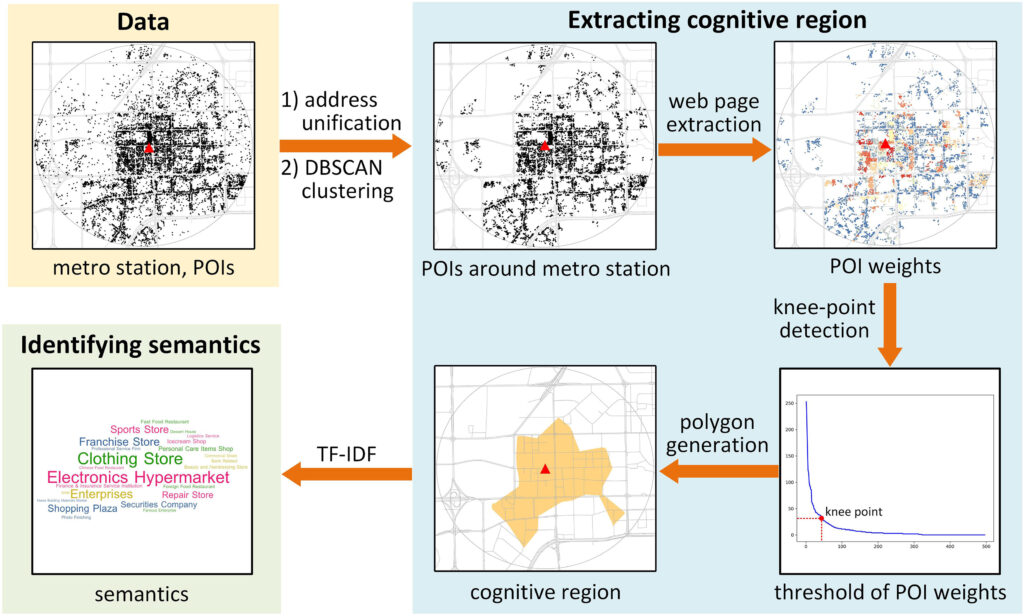
Fig. 1. The proposed framework for extracting and understanding the cognitive regions of urban metro stations.
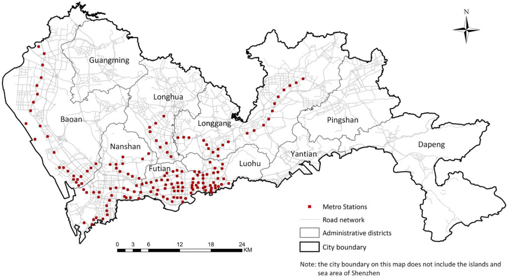
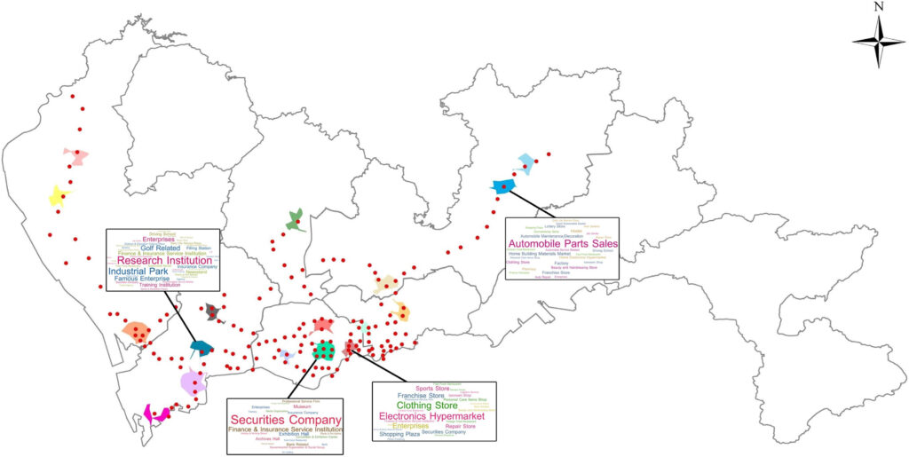
Abstract: The significance of urban metro stations extends beyond their roles as transport nodes in a city. Their surroundings are usually well developed and attract a lot of human activities, which make the metro station areas important cognitive places characterized by vague boundaries and rich semantics. Current studies mainly define metro station areas based on an estimation of walking distance to the stations (e.g., 700 m) and investigate these areas from the perspectives of transportation and land use instead of as cognitive places perceived by the crowd. To fill this gap, this study proposes a novel framework for extracting and understanding the cognitive regions of urban metro stations based on points of interest (POIs). First, we extract the cognitive regions of metro stations based on co-occurrence patterns of the stations and their surrounding POIs on web pages by proposing a cohesive approach combined of spatial clustering, web page extraction, knee-point detection, and polygon generation techniques. Second, we identify the semantics of metro stations based on POI types inside the regions using the term frequency-inverse document frequency (TF-IDF) method. In total 166 metro stations along with more than one million POIs in Shenzhen, China are utilized as data sources of the case study. The results indicate that our proposed framework can well detect the place characteristics of urban metro stations, which enriches the place-based GIS research and provides a human-centric perspective for urban planning and location-based-service (LBS) applications.
Implications for urban planning
As Kevin Lynch stated in The Image of the City (Lynch, 1960), the skeleton of individuals’ mental images is formed by five types of elements in the city: paths, edges, nodes, districts and landmarks, which mediates in the interaction between humans and their environment. The first thing we want to emphasize in this study is that urban metro stations are also one type of such cognitive elements (i.e., landmarks) in cities; their properties as cognitive places should be considered in urban planning and design so as to match people’s cognition. In addition, our extracted cognitive regions of urban metro stations show diverse and irregular shapes, which indicates that unified physical distances frequently used in existing studies and planning practices cannot precisely define TOD precincts perceived by humans. To this end, what we suggest in this study is that urban planning practices should attach importance to “cognitive place” and “cognitive distance”, which load human experiences and perceptions toward the environments (Briggs, 1973; Montello, 1991). This is also coincident with the ultimate goal of urban planning, urban design, and smart-city construction, i.e., making better human societies and improving human lives (Shaw & Sui, 2019).
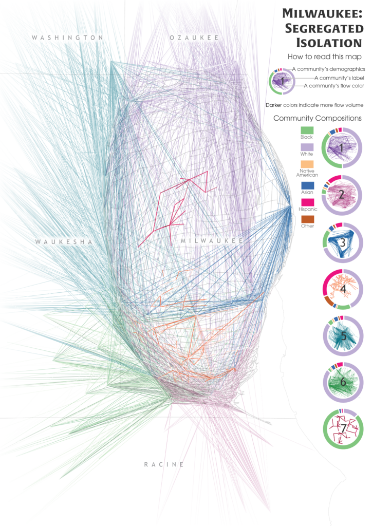
Timothy Prestby, Joseph App, Yuhao Kang, Song Gao. (2019) Understanding Neighborhood Isolation through Spatial Interaction Network Analysis using Location Big Data. Environment and Planning A: Economy and Space. DOI: 10.1177/0308518X19891911
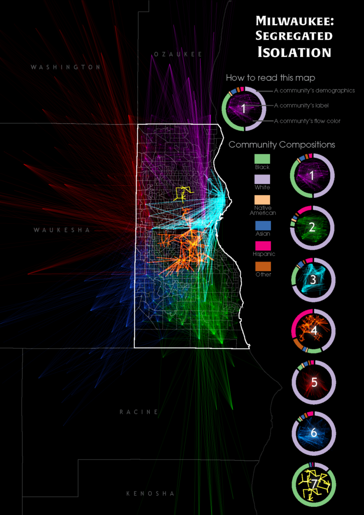
Hidden biases of racial and socioeconomic preferences shape residential neighborhoods throughout the USA. Thereby, these preferences shape neighborhoods composed predominantly of a particular race or income class. However, the assessment of spatial extent and the degree of isolation outside the residential neighborhoods at large scale is challenging, which requires further investigation to understand and identify the magnitude and underlying geospatial processes. With the ubiquitous availability of location-based services, large-scale individual-level location data have been widely collected using numerous mobile phone applications and enable the study of neighborhood isolation at large scale. In this research, we analyze large-scale anonymized smartphone users’ mobility data in Milwaukee, Wisconsin, to understand neighborhood-to-neighborhood spatial interaction patterns of different racial classes. Several isolated neighborhoods are successfully identified through the mobility-based spatial interaction network analysis.
Keywords: Neighborhood isolation, human mobility, big data, spatial interaction
Spatial interactions between Milwaukee communities and their demographic composition. The brighter flows are places where more flows are overlapping/converging together.The community flows are overlaid on top of a cartogram distorted by the percent of the non-white population of the census block groups to promote a more socially just map.
Acknowledgments
The authors would like to thank Safegraph, Inc., for providing the anonymous mobile phone location big data support. T.P. and S.G. thank the UW-Madison Hilldale Undergraduate/Faculty Research Fellowship for their support for this research.