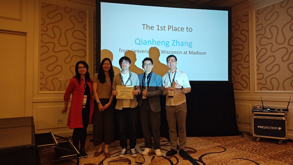
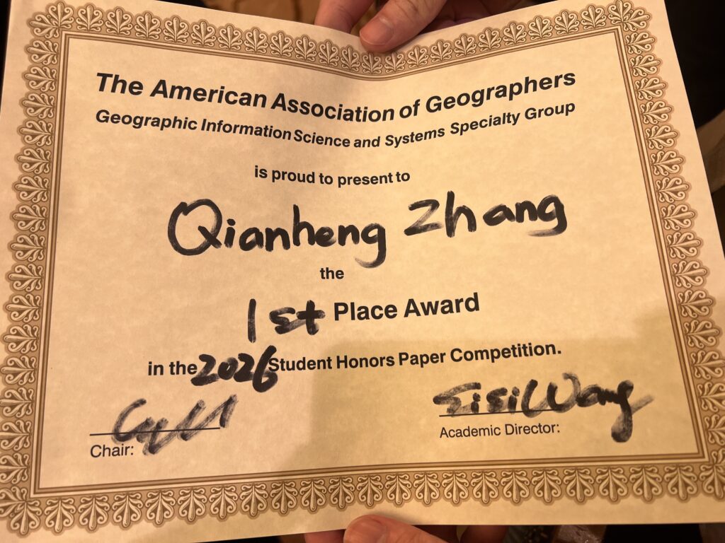
Congratulations to our GeoDS lab PhD student Qianheng Zhang, who just won the 1st place in the “Best Student Honors Paper Competition” of the Geographic Information Science and Systems Specialty Group (GISS-SG) at AAG 2026!
Geospatial Data Science Lab
Congratulations to our GeoDS lab PhD student Qianheng Zhang, who just won the 1st place in the “Best Student Honors Paper Competition” of the Geographic Information Science and Systems Specialty Group (GISS-SG) at AAG 2026!
2026 AAG Annual Meeting, San Francisco, California, March 17-21, 2026
Lead Organizers:
Yingjie Hu, University at Buffalo
Song Gao, University of Wisconsin, Madison
Wenwen Li, Arizona State University
Budhu Bhaduri, Oak Ridge National Laboratory
Orhun Aydin, Saint Louis University
Shawn Newsam, University of California, Merced
Samantha T. Arundel, United States Geological Survey
Gengchen Mai, University of Texas Austin
Krzysztof Janowicz, University of Vienna
The field of GeoAI is advancing rapidly. New AI models, such as vision foundation models, large language models, and multimodal foundation models, provide new possibilities for developing geospatial solutions. Spatial principles, such as Tobler’s First Law, are being incorporated into AI architectures to create spatially explicit models, while explainable GeoAI methods are being explored to improve the interpretability of results. From an application perspective, GeoAI research continues playing positive roles in addressing societal challenges and helping achieve sustainable development goals. Examples include improving individual and population health, enhancing community resilience to disasters, predicting spatiotemporal traffic flows, forecasting climate change impacts on ecosystems, building smart and connected communities and cities, and supporting humanitarian mapping and policymaking. At the same time, the rapid advancement of GeoAI also carries risks, such as the increased opaqueness of large AI models and the environmental costs of training them. How can we continue leveraging GeoAI for making positive impacts while mitigating potential risks? The 2026 AAG GeoAI Symposium aims to bring together geographers, GIScientists, remote sensing scientists, computer scientists, health researchers, urban planners, transportation professionals, disaster response experts, ecologists, earth system scientists, stakeholders, and others to share recent GeoAI research, discuss challenges, and chart the way forward for the coming years.
Sessions at AAG 2026 (the sessions can be accessed at: https://tinyurl.com/333ha64s)
This symposium is sponsored by: AAG GISS, SAM, and CISG specialty groups.

Understanding the interaction between complex urban environments and human mobility flow patterns underpins adaptive transport systems, resilient communities, and sustainable urban developments, yet inter-regional origin-destination mobility flow information from traditional surveys are costly to update. The satellite imagery offers up-to-date information on urban sensing and opens avenues to examine urban morphology-mobility dynamics. This study develops a deep learning model, Imagery2Flow for predicting fine-grained human mobility flows in urban areas using 10 to 30-meter medium resolution satellite imagery in a timely and low-cost manner. Extensive experiments demonstrate good performance and flexible spatial-temporal generalizability on the top-10 largest metropolitan statistical areas of the United States. Through exploring the spatial heterogeneous effects, we investigate the urban factors (centrality and compactness) influencing human movement flow distributions, enhancing our comprehension of their interactions. The spatial transferability of Imagery2Flow helps reduce regional inequality by informing decisions in data-poor regions, learning from data-rich ones. Interestingly, the typologies of urban sprawl can help explain the cross-city model generalization capability. The temporal transferability proves that human dynamics of cities and the process of urbanization can be well captured from the observed built environment by remote sensing.
Xu, Y., Gao, S.*, Huang, Q., Göçmen, A., Zhu, Q., & Zhang, F*. (2025). Predicting human mobility flows in cities using deep learning on satellite imagery. Nature Communications, 16(1), 10372. https://doi.org/10.1038/s41467-025-65373-z
The code of Imagery2Flow is publicly available at GitHub: https://github.com/GeoDS/Imagery2Flow
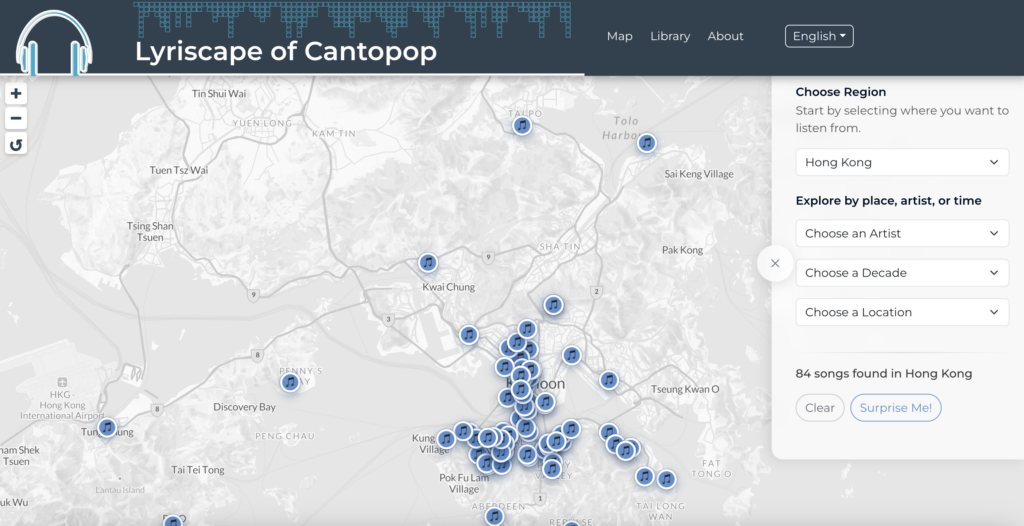
Congratulations to our lab member Qianheng ZHANG (together with Geography PhD student Yanbing Chen) jointly won the 27th Annual Student Dynamic Map Competition at the North American Cartographic Information Society (NACIS) 2025 annual conference.
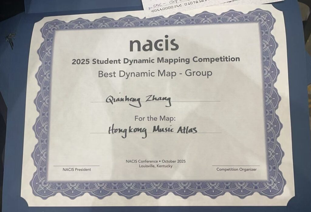
NACIS recognizes the importance of digital and dynamic interactive mapping in Cartography by hosting this competition.The winning team project is the Lyriscape of Cantopop (Hong Kong Music Atlas):
https://qianhengzhang.github.io/HongKongMusicAtlas/#/
GeoDS Lab is excited to welcome two outstanding postdoc research fellows Dr. Ardiantiono and Dr. Zhiyong Zhou joining our group this Fall!
I am a conservation scientist focused on advancing evidence-based conservation in tropical ecosystems. I’ve been fortunate to work with incredible species—from tigers and elephants to Komodo dragons and hornbills. My work centers on optimizing biodiversity monitoring in human-dominated landscapes, fostering human–wildlife coexistence, and strengthening community-based conservation. Working with Prof. Zuzana Burivalova from Sound Forest Lab and Prof. Song Gao from Geospatial Data Science Lab, I’m developing an AI-based framework to integrate camera trap, acoustic, and eDNA data for monitoring the biodiversity benefits of Natural Climate Solutions. I currently serve as President of the Society for Conservation Biology Indonesia (2023-2025) and as an Associate Editor for the Journal of Applied Ecology.
I am a postdoctoral research fellow supported by the Swiss National Science Foundation (SNSF) through the Postdoc.Mobility Fellowship. Prior to joining the GeoDS Lab, I was a postdoc at the Department of Geography, University of Zurich, Switzerland. I hold a Ph.D. in Geography/Earth System Science from the University of Zurich, as well as an M.E. degree and a B.E. degree with Honors from China University of Geosciences (Wuhan). My research focuses on human-centered geospatial AI. I primarily investigate human–space interactions and develop human-adaptive, spatially explicit techniques for spatial data generalization, smart mobility, and sustainable built environments. Additionally, I serve as vice-chair of the ICA Commission on Location-Based Services.
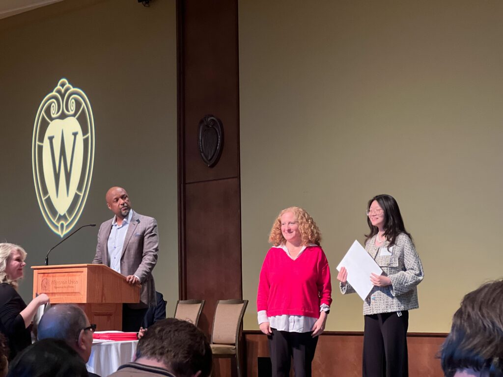
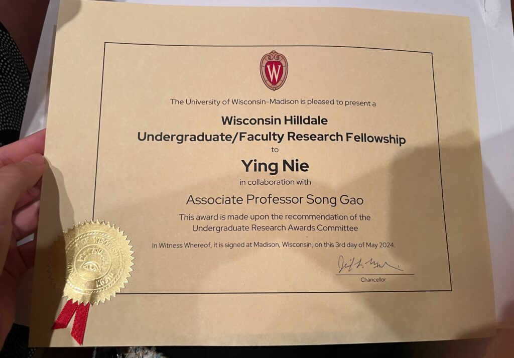
Please join us congratulating our senior student Ying Nie, who is currently an undergraduate majoring in computer science as well as a research assistant in the GeoDS Lab under Prof. Song Gao’s mentorship, just got the UW-Madison “Hilldale Undergraduate/Faculty Research Fellowship” and was awarded in the 2024 Chancellor’s Undergraduate Awards Ceremony!
The awarded research project is: Large Language Model for Intelligent Spatial Analysis Workflow Construction
.

In 2022, our GeoDS Lab’s alumnus Wendy Ye (who is currently a PhD student at USC Compute Science) also got this university fellowship.
In 2019, our GeoDS Lab’s alumnus Timothy Prestby (who is currently a PhD student at PSU Geography) also got this university fellowship.
Other Previous Hilldale Fellows at the University of Wisconsin-Madison:
https://awards.advising.wisc.edu/campus-wide-award-recipients/test-hilldale-fellows/
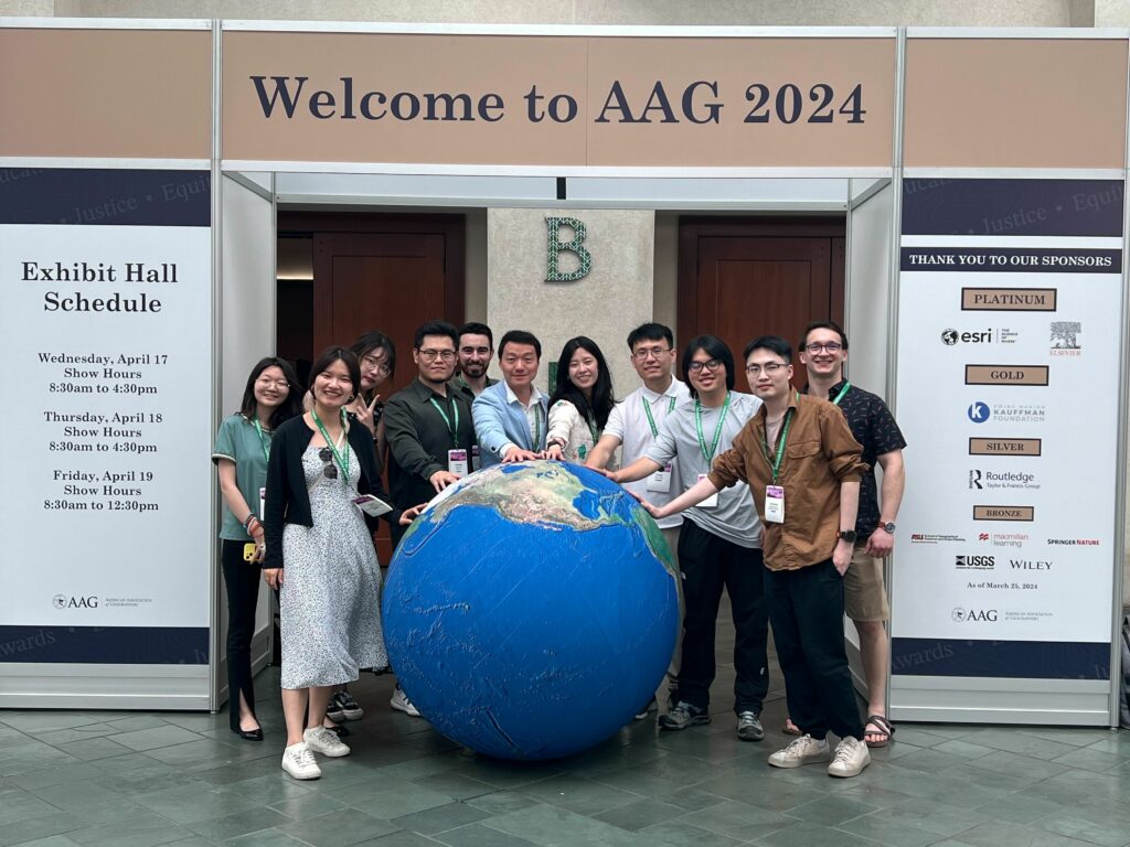
Our GeoDS lab’s students and alumni recently attended the American Association of Geographers (AAG) 2024 Annual Meeting held in Honolulu, HI. It was a great reunion for the GeoDS family at the conference!
Here are the sessions we led and participated:
Type: Panel Date: 4/16/2024
Type: Panel Date: 4/17/2024
Type: Panel Date: 4/17/2024
Type: Panel Date: 4/18/2024
Type: Paper Date: 4/16/2024
Presenter: Yuhan Ji
Type: Paper Date: 4/18/2024
Type: Paper Date: 4/18/2024
Presenter: Qianheng Zhang
Type: Paper Date: 4/18/2024
Presenter: Jake Krue
Type: Paper Date: 4/18/2024
Primary Organizer: Jinmeng Rao, Google DeepMind
Type: Paper Date: 4/19/2024
Primary Organizer: Yuhao Kang, University of South Carolina
Type: Paper Date: 4/19/2024
Presenter: Yichen Xu
Type: Paper Date: 4/20/2024
Presenter: Yunlei Liang
The International Telecommunication Union (ITU) of the United Nations is organizing the webinar series on AI for Good. You are cordially invited to join the forthcoming one is about GeoAI Discovery.
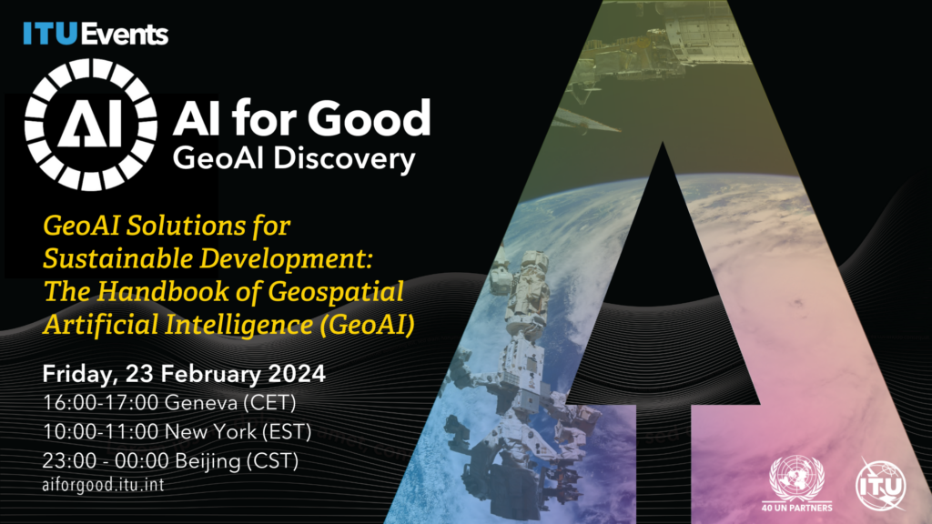
Topic: GeoAI Solutions for Sustainable Development: The Handbook of Geospatial Artificial Intelligence (GeoAI)
Date and Time: 23 February 2024, Friday, at 16:00 CET Geneva | 10:00-11:00 EST, New York | 23:00-00:00 CST, Beijing
Recording link: https://www.youtube.com/live/QHSl4uvioMk?feature=shared
Geospatial Artificial Intelligence (GeoAI) is a rapidly evolving interdisciplinary field that integrates geospatial studies with AI advancements. In this webinar editors and authors of the recently published GeoAI Handbook discuss the fundamental concepts, methods, applications, and perspectives of GeoAI. The GeoAI Handbook is an excellent resource for educators, students, practitioners and decision-makers who are interested in utilizing AI technologies in a geospatial context.
Schedule:
20 mins: Round-table Q&A about the GeoAI Handbook: Maria Antonia Brovelli, Andrea Manara, and Song Gao
10 mins: Chapter 5: GeoAI for Spatial Image Processing: Wenwen Li and Samantha Arundel
10 mins: Chapter 7: Intelligent Spatial Prediction and Interpolation Methods: Di Zhu
10 mins: Chapter 10: Spatial Cross-Validation for GeoAI: Yingjie Hu
10 mins: Wrap-up
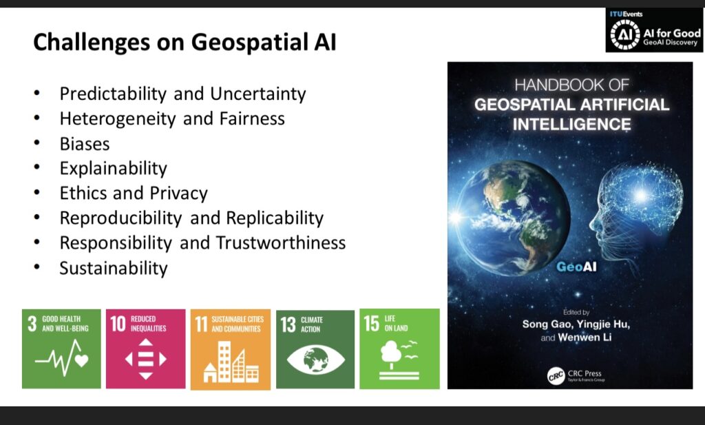
The GeoAI advancements provide promising solutions to address some of the United Nations SDGs but also pose concerns. For example, Chapter 3 presents some of the fundamental assumptions and principles that could form the philosophical foundation of GeoAI and spatial data science. It highlights the sustainability issue for training GeoAI and foundation models that could cause substantial electricity energy and resource consumptions and generate equivalent carbon emissions. Therefore, we need to call for Green AI for achieving the SDG-13: Climate Action. Chapters 13 and 14 discuss existing and prospective GeoAI tools to support humanitarian assistance practices and disaster responses using geospatial big data and machine learning methods, aiming to address the SDG-10: Reduce Inequality and SDG-11: Sustainable Cities and Communities. Chapter 15 focuses on using GeoAI for infectious disease spread prediction to address the SDG-3: Good Health and Well-Being.
AI technologies are advancing rapidly, and new methods and use cases in GeoAI are constantly emerging. As GeoAI researchers, we should not purely hunt for latest AI technologies but should focus on addressing geographic problems and solving grand challenges facing our society as well as achieving sustainable development goals. We also need research effort toward the development of responsible, unbiased, explainable and interpretable GeoAI models to support geographic knowledge discovery and beyond. This GeoAI Handbook was completed in the middle of 2023. While it cannot summarize all GeoAI research in this one handbook, it provides a snapshot of current GeoAI research landscape and helps stimulate future studies in the coming years.
Dear colleagues,
We cannot wait to take our AAG 2024 GeoAI Symposium to Hawaii next year! Collaborating with 40+ colleagues across multiple continents, we have put together a series of paper and panel sessions. In the past year, we have been so excited to witness the rapid and continued growth of GeoAI, the advances in its methods and cross-domain applications. This year’s symposium will highlight these advances and will also include critical discussions on the issues of GeoAI and the societal challenges in its use in science and everyday life.
We welcome you to join us to present your papers, co-organize sessions, and serve as a panelist in our symposium. Your participation is key to helping us expand this exciting research community! If you have any questions, please feel free to reach out to the symposium’s lead organizers. The CFP can be found in the attachment.
AAG 2024 GeoAI Symposium organizing team
Lead Organizers:
Wenwen Li, Arizona State University
Yingjie Hu, University at Buffalo
Song Gao, University of Wisconsin, Madison
Budhu Bhaduri, Oak Ridge National Laboratory
Orhun Aydin, Saint Louis University
Shawn Newsam, University of California, Merced
Samantha T. Arundel, United States Geological Survey
Gengchen Mai, University of Georgia
Krzysztof Janowicz, University of Vienna & University of California, Santa Barbara
Sessions (all sessions can be accessed at: https://bit.ly/aag2024geoai):
To present your research in one of these sessions, please register and submit your abstract at https://aag.secure-platform.com/aag2024/. When you receive confirmation of your submission, please forward your confirmation email to the session organizers by Nov. 16, 2023.
The 31st ACM SIGSPATIAL International Conference on Advances in Geographic Information Systems (ACM SIGSPATIAL 2023) will be held in Hamburg, Germany, Monday November 13 – Thursday November 16, 2023. This is the flagship international conference organized by the special interest group of SPATIAL at ACM.
GeoDS lab members have two vision papers about GeoAI Foundation Models (Geo-Foundation Models) accepted as oral presentations.
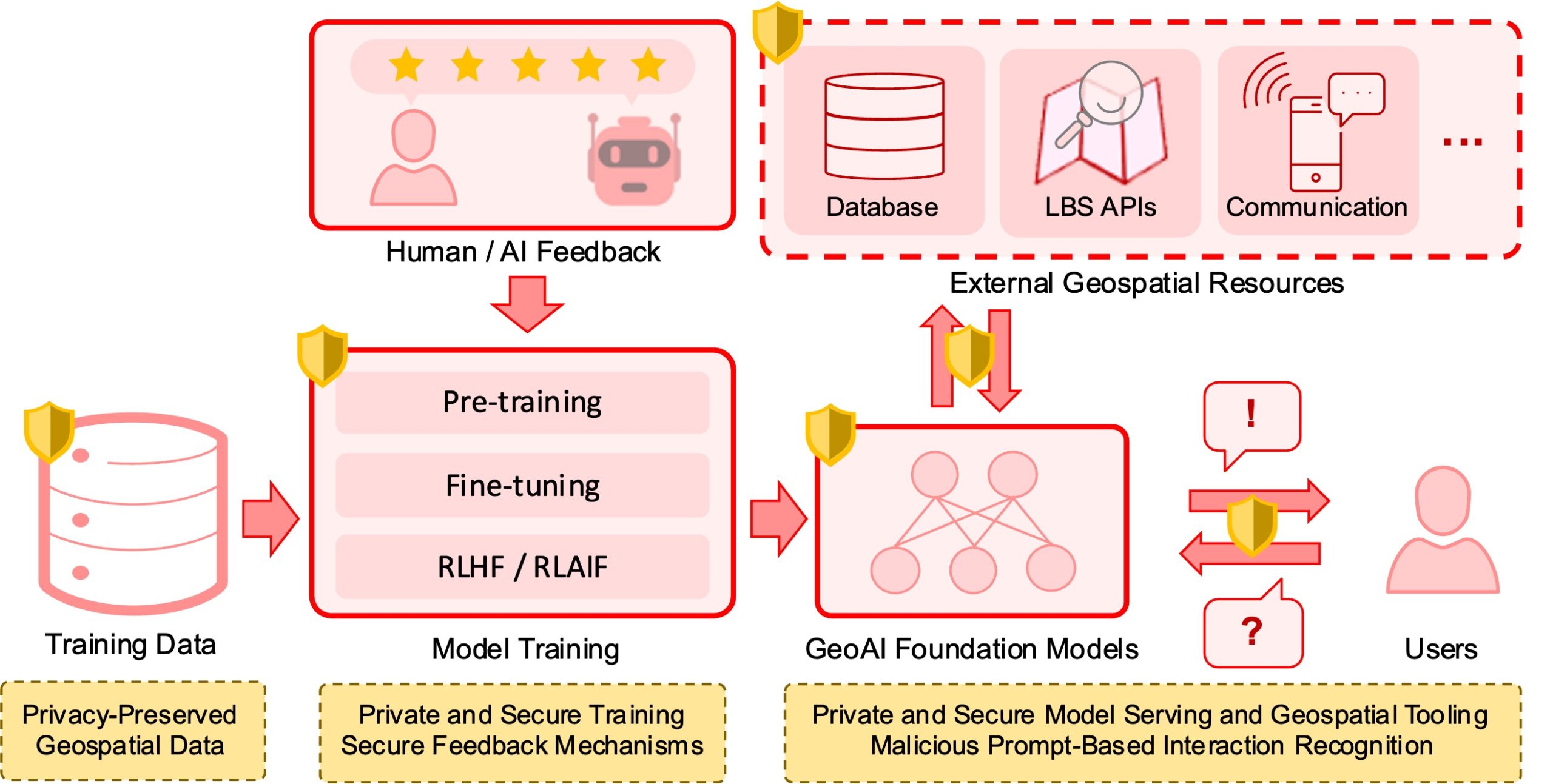
Jinmeng Rao, Song Gao, Gengchen Mai, Krzysztof Janowicz. (2023) Building Privacy-Preserving and Secure Geospatial Artificial Intelligence Foundation Models (Vision Paper).
Abstract: In recent years we have seen substantial advances in foundation models for artificial intelligence, including language, vision, and multimodal models. Recent studies have highlighted the potential of using foundation models in geospatial artificial intelligence, known as GeoAI Foundation Models or Geo-Foundation Models, for geographic question answering, remote sensing image understanding, map generation, and location-based services, among others. However, the development and application of GeoAI foundation models can pose serious privacy and security risks, which have not been fully discussed or addressed to date. This paper introduces the potential privacy and security risks throughout the lifecycle of GeoAI foundation models and proposes a comprehensive blueprint for preventative and control strategies. Through this vision paper, we hope to draw the attention of researchers and policymakers in geospatial domains to these privacy and security risks inherent in GeoAI foundation models and advocate for the development of privacy-preserving and secure GeoAI foundation models.
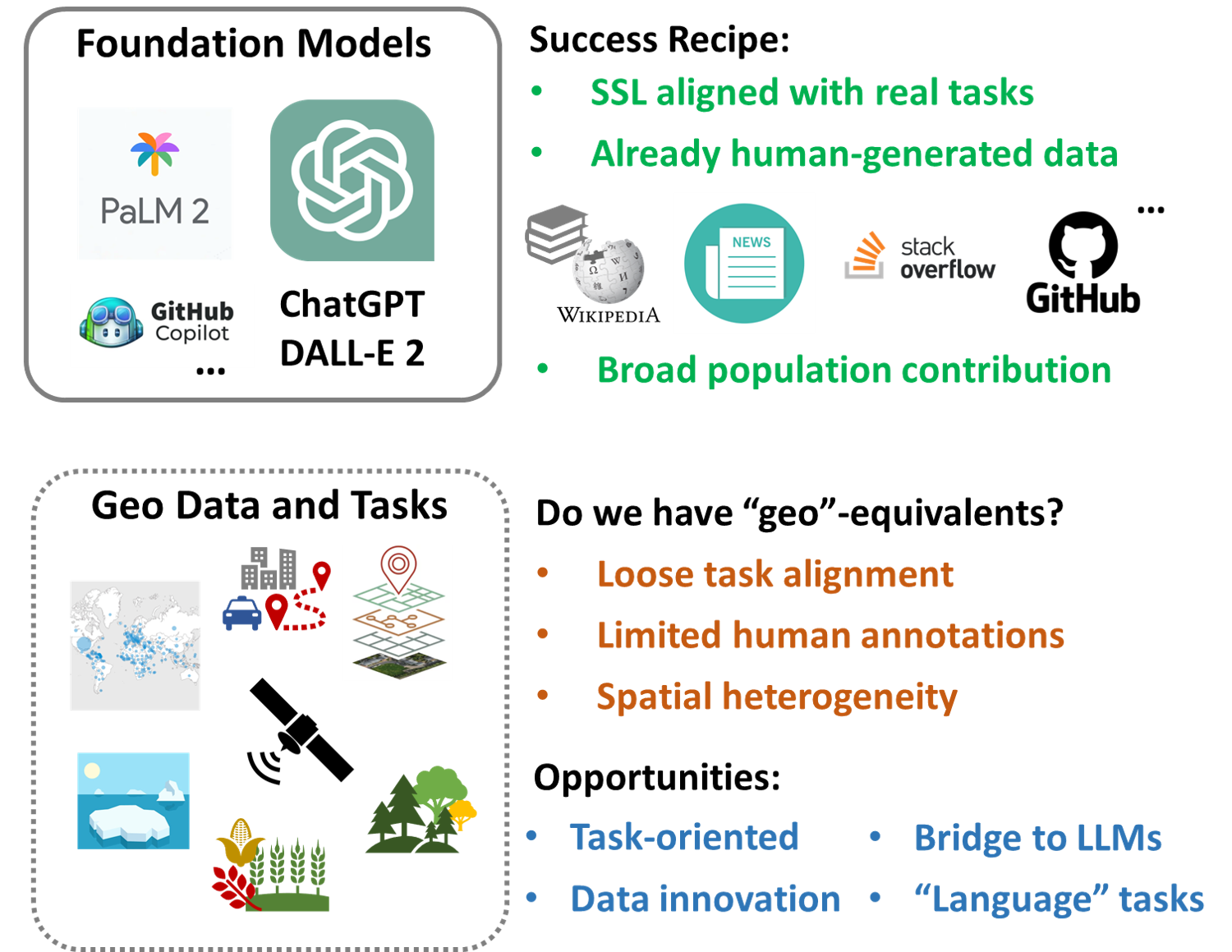
Yiqun Xie, Zhaonan Wang, Gengchen Mai, Yanhua Li, Xiaowei Jia, Song Gao and Shaowen Wang. (2023) “Geo”-Foundation Models: Reality, Gaps and Opportunities (Vision Paper).
Abstract: With the recent rapid advances of revolutionary AI models such as ChatGPT, foundation models have become a main topic for the discussion of future AI. Despite the excitement, the success is still limited to specific types of tasks. Particularly, ChatGPT and similar foundation models have unique characteristics that are difficult to replicate for most geospatial tasks. This paper envisions several major challenges and opportunities in the creation of geospatial foundation (geo-foundation) models, as well as potential future adoption scenarios. We also expect that a major success story is necessary for geo-foundation models to take off in the long term.
Please join us in congratulating our GeoDS lab’s PhD students and undergraduate students’ recent awards and achievements!
Yuhao Kang:
2023 Waldo-Tobler Young Researcher Award in GIScience, by the Austrian Academy of Sciences (ÖAW) Commission for GIScience to encourage scientific advancement in the disciplines of Geoinformatics and/or Geographic Information Science.
2023 CaGIS PhD Student Scholarship Award and 2023 CaGIS RISING research grant, by U.S. Cartography and Geographic Information Society (CaGIS)
Jake Kruse:
2023 Invited Presentation at the UW-Madison Day at the State Capitol of Wisconsin
Yichen Xin (Undergraduate):
2023 Undergraduate Student Winner of the Peter Gould Best Paper Award, by the AAG Health and Medical Geography Specialty Group (HMGSG)
Wen Ye (Undergraduate):
2023 Undergraduate Fellows Seminar, Hilldale Undergraduate/Faculty Research Fellowships by UW-Madison
Sessions at the 2023 AAG GeoAI Symposium (PDF download)
Symposium Lead Organizers:
Yingjie Hu, University at Buffalo
Song Gao, University of Wisconsin, Madison
Wenwen Li, Arizona State University
Dalton Lunga, Oak Ridge National Laboratory
Orhun Aydin, Saint Louis University
Shawn Newsam, University of California, Merced
3/23/2023, Thursday
GeoAI and Deep Learning Symposium: GeoAI for Feature Detection and Recognition
GeoAI and Deep Learning Symposium: Deploying AI for Geospatial Data and Remote Sensing: Advances, Challenges and Obstacles
GeoAI and Deep Learning Symposium: A 5-year Milestone: Advances and Limitations in GeoAI Research So Far
GeoAI and Deep Learning Symposium: Emerging Geo-Data Applications in Human Mobility Analysis
GeoAI and Deep Learning Symposium: GeoAI for Cartography and Mapping
3/24/2023, Friday
GeoAI and Deep Learning Symposium: Spatial Data Science for Ecosystem Conservation and Biodiversity
GeoAI and Deep Learning Symposium: Spatially Explicit Machine Learning and Artificial Intelligence I
GeoAI and Deep Learning Symposium: Spatially Explicit Machine Learning and Artificial Intelligence II
GeoAI and Deep Learning Symposium: Spatially Explicit Machine Learning and Artificial Intelligence III
3/25/2023, Saturday
GeoAI and Deep Learning Symposium: Intelligent Geospatial Analytics
GeoAI and Deep Learning Symposium: GeoAI for Disaster Resilience
3/26/2023, Sunday
GeoAI and Deep Learning Symposium: Urban Visual Intelligence
GeoAI and Deep Learning Symposium: Geoprivacy and Ethics in Geospatial Data and GeoAI
Program Committee:
Sean C. Ahearn, Hunter College — CUNY
Samantha T. Arundel, US Geological Survey
Orhun Aydin, Saint Louis University
Andrea Ballatore, King’s College London
Budhendra Bhaduri, Oak Ridge National Lab
Ling Bian, University at Buffalo
Kai Cao, East China Normal University
Guofeng Cao, University of Colorado, Boulder
Yao-Yi Chiang, University of Minnesota-Twin Cities
Somayeh Dodge, University of California Santa Barbara
Chen-Chieh Feng, National University of Singapore
Amy Frazier, Arizona State University
Michael F. Goodchild, University of California, Santa Barbara
Majid Hojati, Wilfrid Laurier University
Yingjie Hu, University at Buffalo
Xiao Huang, University of Arkansas
Qunying Huang, University of Wisconsin, Madison
Jamon Van Den Hoek, Oregon State University
Krzysztof Janowicz, University of Vienna & University of California, Santa Barbara
Chaogui Kang, China University of Geosciences
Yuhao Kang, University of Wisconsin, Madison
Carsten Keßler, Aalborg University Copenhagen
Morteza Karimzadeh, University of Colorado Boulder
Jina Kim, University of Minnesota
Junghwan Kim, Virginia Tech
Nina Lam, Louisiana State University
Xiaojiang Li, Temple University
Wenwen Li, Arizona State University
Xiao Li, University of Oxford
Yu Liu, Peking University, China
Tao Liu, Michigan Technological University
Grant McKenzie, McGill University
Antonio Medrano, Texas A&M University Corpus Christi
Gengchen Mai, University of Georgia
Yi Qiang, University of South Florida
Alex Sorokine, Oak Ridge National Lab
Avipsa Roy, University of California, Irvine
Kathleen Stewart, University of Maryland, College Park
Marcela Suárez, Penn State University
Wenwu Tang, University of North Carolina at Charlotte
Daoqin Tong, Arizona State University
Ming-Hsiang Tsou, San Diego State University
Mingshu Wang, University of Glasgow
Shaohua Wang, Chinese Academy of Sciences
Shaowen Wang, University of Illinois, Urbana-Champaign
Zhangyu Wang, University of California Santa Barbara
Dawn Wright, Esri Inc.
Hsiuhan (Lexie) Yang, Oak Ridge National Laboratory
Haowen Xu, Oak Ridge National Laboratory
Angela Yao, University of Georgia
Xinyue Ye, Texas A&M University
Eun-Hye Enki Yoo, University at Buffalo
Manzhu Yu, Penn State University
May Yuan, University of Texas at Dallas
Fan Zhang, Hong Kong University of Science and Technology
Hongyu Zhang, McGill University
Bo Zhao, University of Washington
A-Xing Zhu, University of Wisconsin, Madison
Di Zhu, University of Minnesota, Twin Cities
Lei Zou, Texas A&M University
This symposium is sponsored by: AAG GISS, CI and SAM specialty groups
Recently, Prof. Song Gao was invited to join the Associate Editors team of International Journal of Geographical Information Science (IJGIS), which is a flagship international journal for publishing geographic information systems/science related research. Dr. Gao’s service term starts from January 1st, 2023.
Aims and Scope
The aim of International Journal of Geographical Information Science is to provide a forum for the exchange of original ideas, approaches, methods and experiences in the field of GIScience.
International Journal of Geographical Information Science covers the following topics:
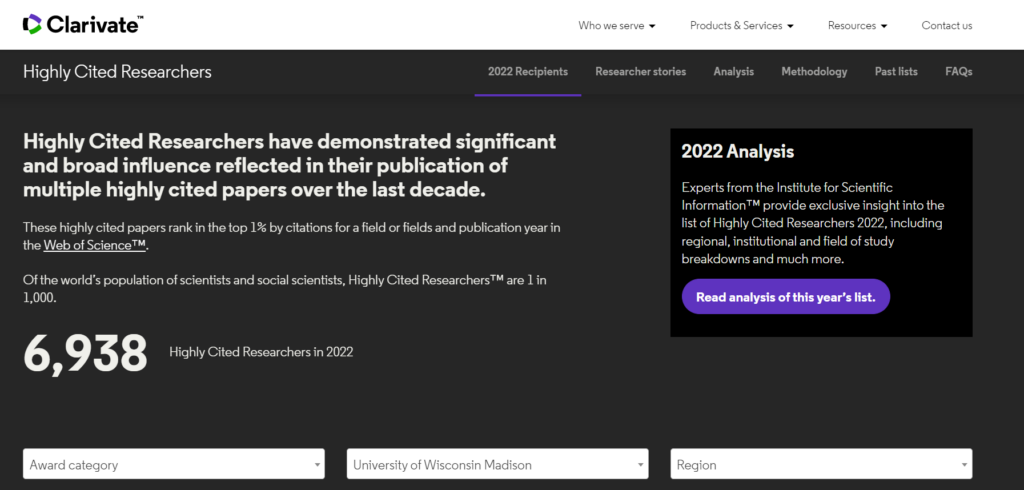
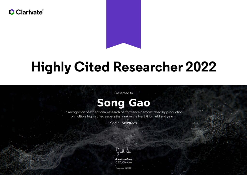
Prof. Song Gao is on this year’s list of Global Highly Cited Researchers List of 2022 and the only scholar from UW-Madison listed in the category of Social Sciences. Kudos to his colleagues, students, and mentors!
On November 15 2022, Clarivate revealed its 2022 list of Highly Cited Researchers™ – individuals at universities, research institutes and commercial organizations who have demonstrated a disproportionate level of significant and broad influence in their field or fields of research. The methodology draws on data from the Web of Science™ citation index, together with analysis performed by bibliometric experts and data scientists at the Institute for Scientific Information (ISI)™ at Clarivate. ISI analysts have awarded Highly Cited Researcher 2022 designations to 6,938 researchers from across the globe who demonstrated significant influence in their chosen field or fields over the last decade. ISI analyzed all papers published and cited between 2011 and 2021, determining which authors ranked in the top 1% of cited papers in each field. The list is truly global, spanning 69 countries or regions and spread across a diverse range of research fields in the sciences and social sciences.
Prof. Gao is also on the list of top 2% highly cited scientists based on Stanford University’s analysis of Scopus data provided by Elsevier.
UW-Madison Research News: https://research.wisc.edu/uncategorized/2022/11/22/uw-madison-faculty-make-strong-showing-on-global-highly-cited-researchers-list/