New Research Chapter about Store Visit Patterns during COVID-19 Published

Yunlei Liang, Kyle W. McNair, Song Gao, Aslıgül Göçmen. (2021). Exploring Store Visit Changes During the COVID-19 Pandemic Using Mobile Phone Location Data. In Shih-Lung Shaw and Daniel Sui (Eds): Mapping COVID-19 in Space and Time: Understanding the Spatial and Temporal Dynamics of a Global Pandemic (Chapter 13). pp. 253-275, Springer.

Abstract:

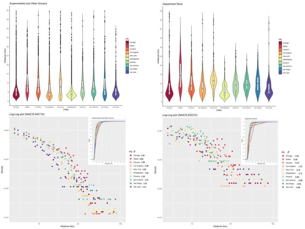
When the World Health Organization (WHO) announced the pandemic of COVID-19, people around the globe scattered to stores for groceries, supplies, and other miscellaneous items in preparation for quarantine. The dynamics of retail visits changed dramatically due to the pandemic outbreak. The study intends to analyze how the store visit patterns have changed due to the lockdown policies during the COVID-19 pandemic. Using mobile phone location data, we build a time-aware Huff model to estimate and compare the visiting probability of different brands of stores over different time periods. We are able to identify certain retail and grocery stores that have more or fewer visits due to the pandemic outbreak, and we detect whether there are any trends in visiting certain retail establishments (e.g., department stores, grocery stores, fast-food restaurants, and cafes) and how the visiting patterns have adjusted with lockdowns. We also make comparisons among brands across three highly populated U.S. cities to identify potential regional variability. It has been found that people in large metropolitan areas with a well-developed transit system tend to show less sensitivity to long-distance visits. In addition, Target, which is a department store, is found to be more negatively affected by longer-distance trips than other grocery stores after the lockdown. The findings can be further applied to support policymaking related to public health, urban planning, transportation, and business in post-pandemic cities.

Highlighted results:

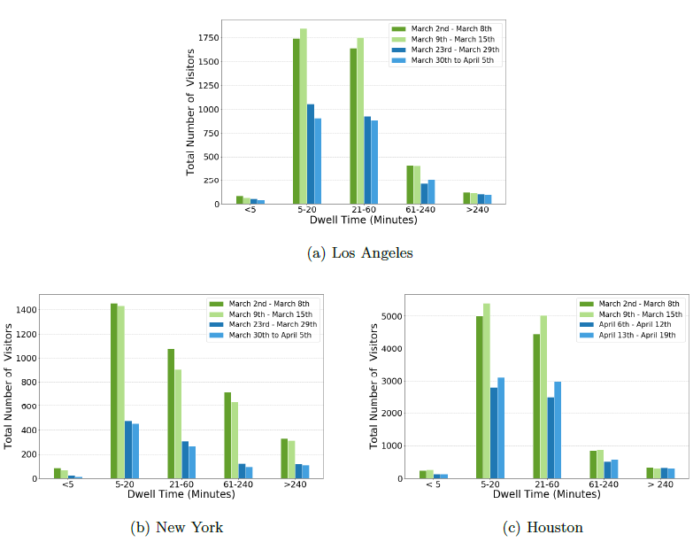
  • The dwell time distribution of visitors in Target.
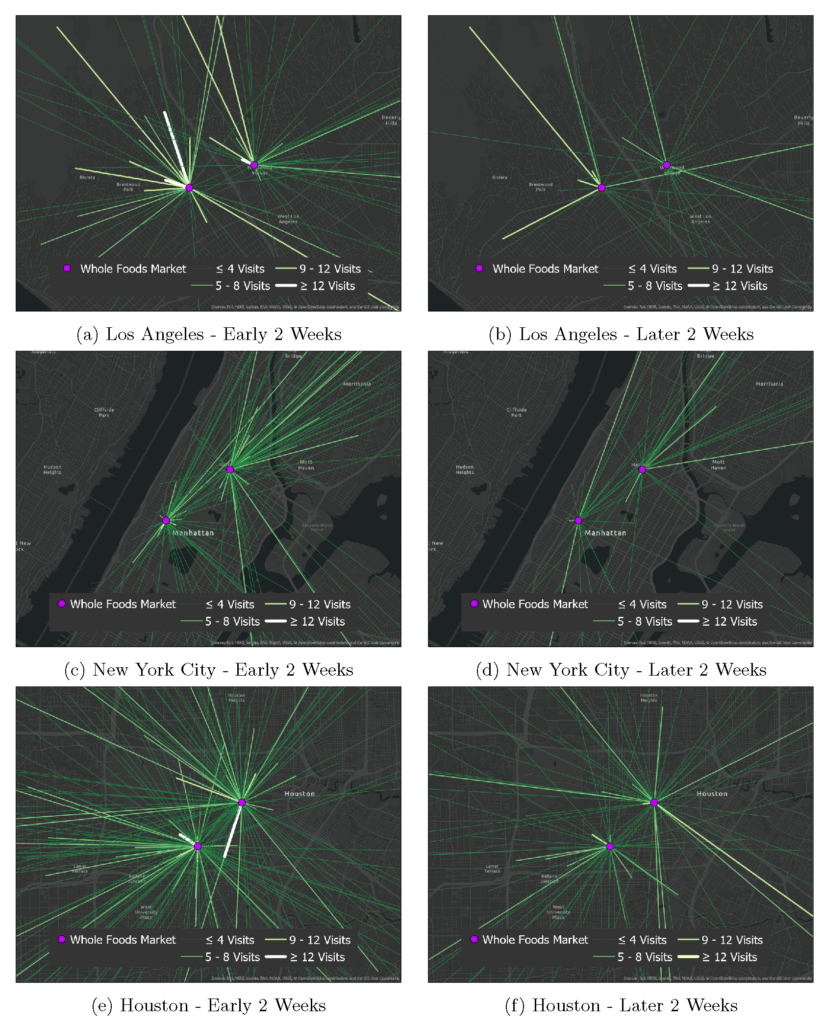
  • Frequency of Visits from home Census Block Groups to Whole Foods Markets.

GeoDS Lab students’ industry internship experience

Besides schoolwork, students in the GeoDS lab also have the opportunity to work as interns in geospatial industries over the summer. They are able to apply their Cartography/GIS/Spatial Data Science knowledge & skills learned at school to solve some real-world problems and build a better understanding of what are key knowledge & skills that can make a difference! Two students Yunlei Liang and Jinmeng Rao are sharing their summer internship experience in summer 2020 in this post.

In addition, please join us to congratulate lab members and alumni: Yuhao Kang (Google X), Jake Kruse (Arity, Allstate), Jinmeng Rao (Google X), and Timothy Prestby (Apple Maps) will take their 2021 summer internships .

Yunlei Liang :

Last summer, I worked as a Data Science Intern at Arity, a mobility data and analytics company under Allstate. I was very lucky to work on two teams. In the first team, I worked on understanding the impact of COVID-19 on the user trajectories and analyzing how the model and statistics have changed because of the reduced travel. In the second team, I was responsible for evaluating Points of Interest (POIs) from different vendors. I matched their classification and locations, identified the coverage quality, assigned scores to each vendor and produced a recommendation report to the team.

Through this 12-week internship, I learned a lot of technical skills, which also helps me realize what are important knowledge I should improve back to school. The cross-team experience made me learn how to work in a team. It was very different than what I did in school. In a company, I am expected to communicate with different people: my mentor, my teammates, and people from other teams. Understanding what others are doing is extremely important as collaboration is fairly common, and people always help each other by discussing solutions to various problems. Being active and always reaching out to others are my main takeaways from this internship. I also learned a lot of such experience from my previous internship in the Data Science team at Wework Inc.

Jinmeng Rao:

Last summer, I worked as a Geospatial Vision Intern at Sturfee Inc., a spatial intelligence company focusing on Visual Positioning Service (VPS), to design and implement computer vision algorithms and toolkits on geospatial data (e.g., street/satellite view images, GPS traces) to improve city-scale AR experience.

During my 3-month internship at Sturfee, our team developed a cross-view Perspective-n-Point (PnP) aligner tool for estimating and refining camera pose based on satellite images and street view images. My main tasks were to design an efficient algorithm to synthesize aerial view images from street view images and to integrate the algorithm into the tool. After the integration, the camera pose estimation accuracy is significantly improved, and the PnP aligner tool becomes much easier to use. I also worked on designing a grid-based keypoint matching algorithm to automatically find matching points between two different views and search for the best camera pose accordingly.

My internship experience at Sturfee is great and fruitful. As an intern, I had a chance to learn state-of-the-art industrial solutions, and I got a general picture of what the industry cares about more. The biggest takeaway for me is that I learned how to apply our skills to solve some real-world problems in the industry. I believe my experience at Sturfee will help me do better in research or work in the future.

Location Big Data for Business Analytics

Reference: Yunlei Liang, Song Gao, Yuxin Cai, Natasha Z. Foutz, Lei Wu. (2020) Calibrating the dynamic Huff model for business analysis using location big data. Transactions in GIS, 24(3), 681-703.

Abstract: The Huff model has been widely used in location‐based business analysis to delineate a trade area containing a store’s potential customers. Calibrating the Huff model and its extensions requires empirical location visit data. Many studies rely on labor‐intensive surveys. With the increasing availability of mobile devices, users in location‐based platforms share rich multimedia information about their locations at a fine spatio‐temporal resolution, which offers opportunities for business intelligence. In this research, we present a time‐aware dynamic Huff model (T‐Huff) for location‐based market share analysis and calibrate this model using large‐scale store visit patterns based on mobile phone location data across the 10 most populated US cities. By comparing the hourly visit patterns of two types of stores, we demonstrate that the calibrated T‐Huff model is more accurate than the original Huff model in predicting the market share of different types of business (e.g., supermarkets versus department stores) over time. We also identify the regional variability where people in large metropolitan areas with a well‐developed transit system show less sensitivity to long‐distance visits. In addition, several socioeconomic and demographic factors (e.g., median household income) that potentially affect people’s visit decisions are examined and summarized.

The Whole Foods Markets in Los Angeles with their temporal visit probability.
The spatial distributions of CBGs that have visit flows to five Whole Foods Markets.
The probability density distribution, empirical cumulative distribution, and log-log plots of visitors’ distance from home to supermarkets and grocery stores (NACIS: 445110) and to department stores (NACIS: 452210) in the top 10 most populated cities in US.
(a) Estimated market share of five Whole Foods Market stores in Los Angeles using the original Huff model; and (b) Actual market share derived from the SafeGraph visit database.

Prof. Michael F. Goodchild visited UW-Madison

Recently, Prof. Mike Goodchild was invited to visit our lab and the Department of Geography at the University of Wisconsin-Madison. Prof. Goodchild is the Emeritus Professor of Geography at the University of California, Santa Barbara. He was elected member of the National Academy of Sciences and the American Academy of Arts and Sciences, etc. He gave a talk titled “Geography and GIScience: An Evolving Relationship” in the department Yi-Fu Tuan Lecture series on Friday, April 19th, shared his view of how GIScience and Geography evolved together during the past decades.

The GeoDS lab also invited Prof. Goodchild to join our research group meeting. Four lab members presented their recent works and received insightful suggestions and comments from Prof. Goodchild.

GeoDS Lab at the 2019 AAG Annual Meeting

During the last week (April 3-7), six GeoDS lab members have actively participated in the 2019 AAG Annual meeting and successfully presented their work. Especially congratulations to Yuhao Kang who won the first place in the Robert Raskin Student best paper competition!

Yuhao Kang presented his work titled “Human Emotions at Different Places: A Ranking of Happiest Tourist Attractions around the World Based on Facial Expressions and Spatial Clustering Analysis” in the Cyberinfrastructure Specialty Group Student paper competition Session. [Abstract]. Robert Raskin Student Competition 2019: http://gis.cas.sc.edu/cisg/?page_id=126

Yunlei Liang presented her work titled “Optimizing Bus Stop Spacing Using a Spatial Interaction Coverage Model and the Maximal Covering Location Problem Model” in the Spatial Analysis and Modeling Specialty Group Student paper competition Session. [Abstract]

Mingxiao Li presented his work titled “Reconstruction of human movement trajectories from large-scale low-frequency mobile phone data” in the GeoAI and Deep Learning Symposium. [Abstract]

Yuqi Gao presented her work named “Analyzing Regional Economic Indicators from Transportation Network Analytics” in the Automated GISci for Network-based Decisions Session. [Abstract]

Timothy Prestby presented his work titled “Linking Traffic Volume to Economic Development Index Using Big Data and Gravity Models” in the Urban Geography Poster Session. [Poster]

Professor Song Gao co-organized The 2nd AAG Symposium on GeoAI and Deep Learning for Geospatial Research and was invited to the panel discussions of “Urban Data Science”.

Congrats to all of them! Go Badgers!

Group Photo