Reference: Rao, J., Gao, S., Kang, Y., & Huang, Q. (2020). LSTM-TrajGAN: A Deep Learning Approach to Trajectory Privacy Protection. In the Proceedings of the 11th International Conference on Geographic Information Science (GIScience 2021), No. 12; pp. 12:1–12:17. DOI: 10.4230/LIPIcs.GIScience.2021.12 [PDF]
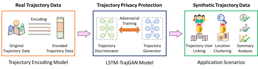
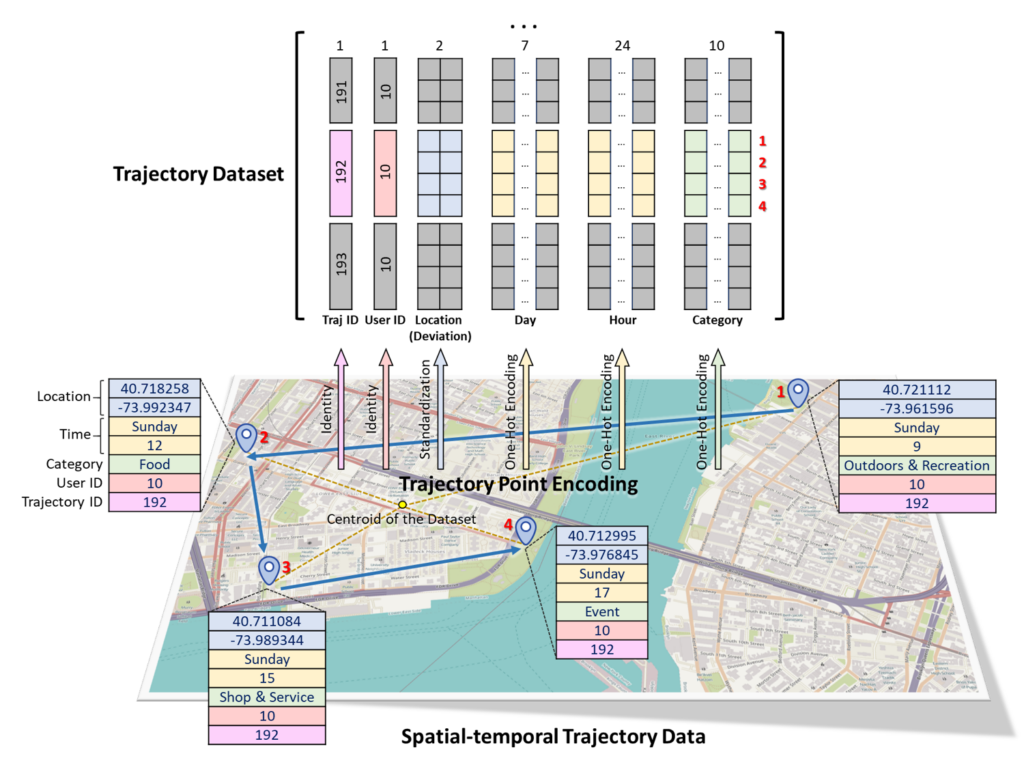
Abstract: The prevalence of location-based services contributes to the explosive growth of individual-level trajectory data and raises public concerns about privacy issues. In this research, we propose a novel LSTM-TrajGAN approach, which is an end-to-end deep learning model to generate privacy-preserving synthetic trajectory data for data sharing and publication. We design a loss metric function TrajLoss to measure the trajectory similarity losses for model training and optimization. The model is evaluated on the trajectory-user-linking task on a real-world semantic trajectory dataset. Compared with other common geomasking methods, our model can better prevent users from being re-identified, and it also preserves essential spatial, temporal, and thematic characteristics of the real trajectory data. The model better balances the effectiveness of trajectory privacy protection and the utility for spatial and temporal analyses, which offers new insights into the GeoAI-powered privacy protection.
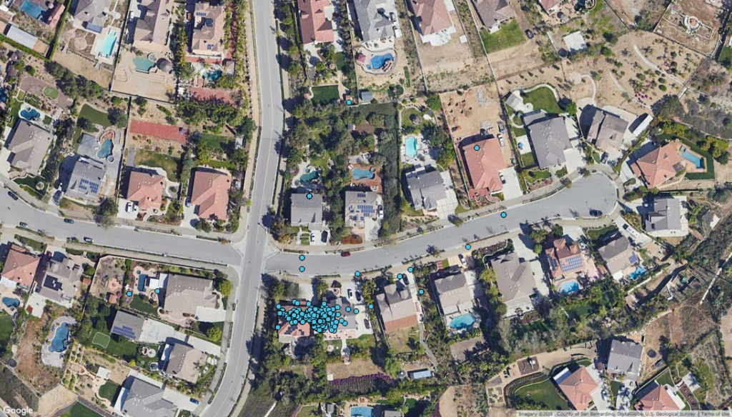
Figure 1: The spatial distribution of geotagged tweets around a Twitter user’s home.
Reference: Song Gao, Jinmeng Rao, Xinyi Liu, Yuhao Kang, Qunying Huang, Joseph App. (2019) Exploring the effectiveness of geomasking techniques for protecting the geoprivacy of Twitter users.Journal of Spatial Information Science. 19, 105-129. DOI: 10.5311/JOSIS.2019.19.510[PDF]
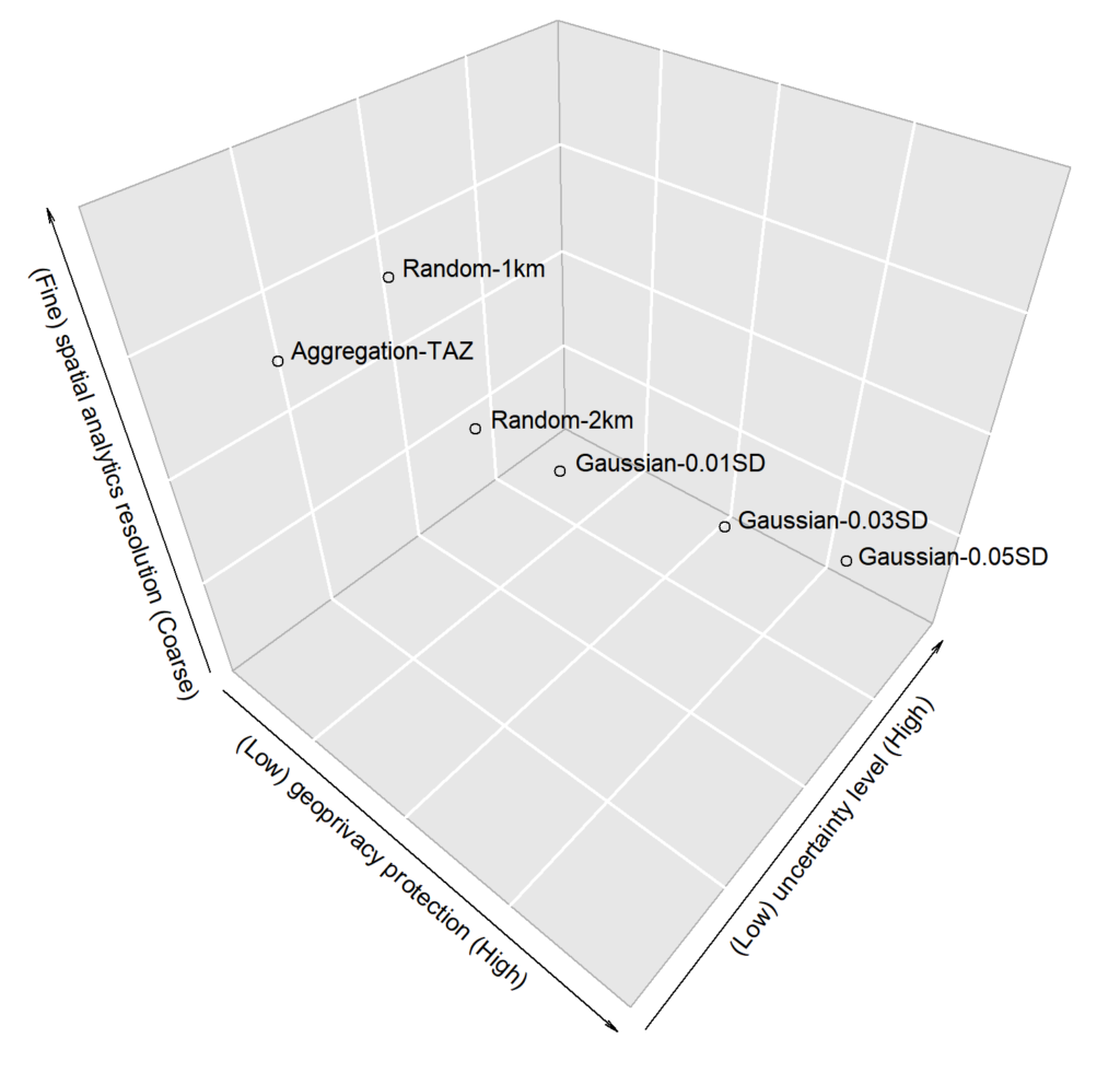
Abstract: With the ubiquitous use of location-based services, large-scale individual-level location data has been widely collected through location-awareness devices. Geoprivacy concerns arise on the issues of user identity de-anonymization and location exposure. In this work, we investigate the effectiveness of geomasking techniques for protecting the geoprivacy of active Twitter users who frequently share geotagged tweets in their home and work locations. By analyzing over 38,000 geotagged tweets of 93 active Twitter users in three U.S. cities (Los Angeles, Madison, and Washington D.C.), the two-dimensional Gaussian masking technique with proper standard deviation settings is found to be more effective to protect user’s location privacy while sacrificing geospatial analytical resolution than the random perturbation masking method and the aggregation on traffic analysis zones. Furthermore, a three-dimensional theoretical framework considering privacy, spatialanalytics, and uncertainty factors simultaneously is proposed to assess geomasking techniques. Our research offers insights into geoprivacy concerns of social media users’ georeferenced data sharing for future development of location-based applications and services.
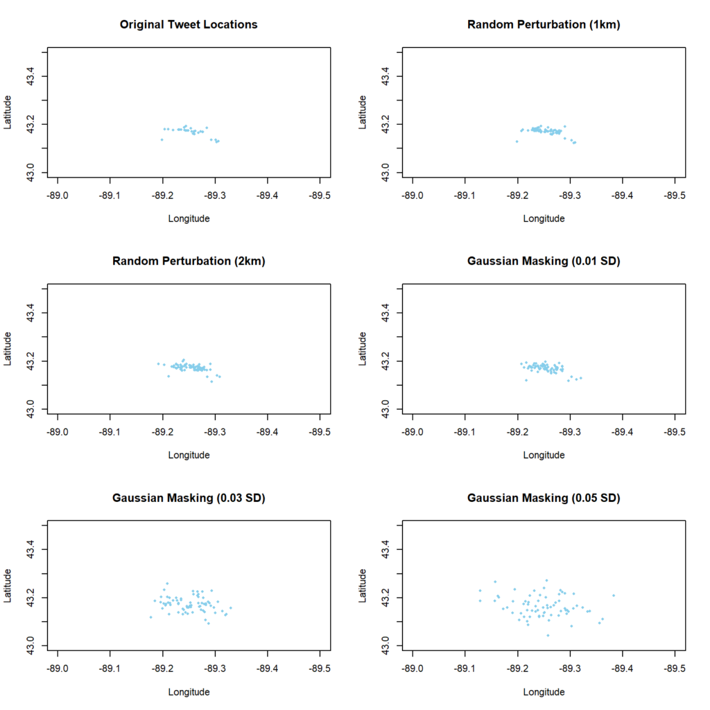
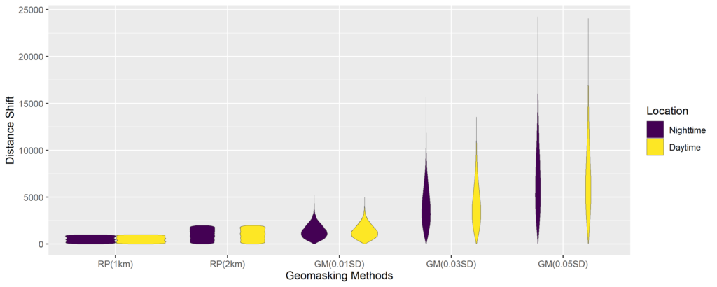
Figure 2: The Gaussian geomasking with different standard deviations (SD) and the random perturbation with 1km and 2km threshold of a user’s geotagged tweets.Figure 10: The violin plot of distance shifts of tweet locations after geomasking.Figure 11: A 3D-cube framework for assessing different geomasking techniques; the position of each method is estimated from the results of our case study.
Broader Impacts: In fact, Twitter removes support for precise geotagging since June, 2019. However, the metadata of historical tweets prior to the policy change may still reveal precise GPS coordinates. In addition, when a user deletes a geotagged tweet , Twitter does not guarantee the information will be completely removed from all copies of the data on third-party applications or in external search results. Even if the precise GPS location is not available anymore, Twitter users are still able to add place tags (e.g., a city, office building, apartment, landmark, and many other types of places) to their geotagged tweets, which can be converted to the GPS coordinates (often using the centroid as a representation location). This is similar to the aforementioned aggregation-based masking approach, thus we may still be able to get users’ sensitive locations based on fine-scale place tags. People should be aware that sharing or publishing such kind of location data involve geoprivacy issues and the geomasking technique provides a way to help mitigate the problem not only for Twitter users but also for other telematics and social media platforms such as Facebook, Flickr, Weibo, and Instagram where geotagging or place-tagging is accessible, as well as for mobile applications that track individual locations.