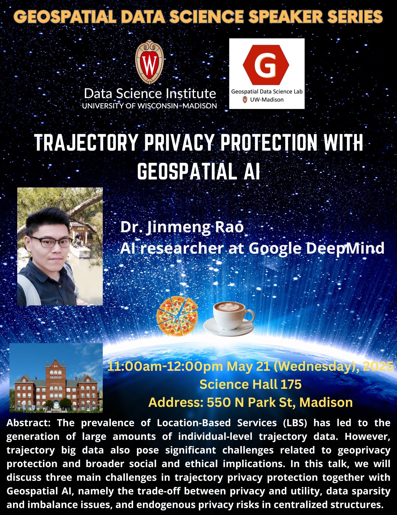
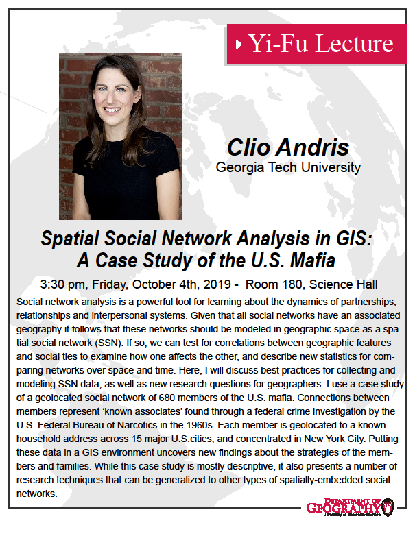
Geospatial Data Science Seminar with Dr. Di Zhu

Title: Spatial Networks and AI for Social Sensing

Abstract: Cities pulse with life. People, information, and resources move through streets and neighborhoods, weaving the spatial structures of human-environment interactions in cities. While the proliferation of spatiotemporal data and advances in computational methods have significantly enhanced our ability to sense human activities and characterize geographic places, the power of spatial networks that organize our urban systems is still underutilized. Focusing on three missing pieces in contemporary urban social sensing: connected places, invisible flows, and unknown mechanisms, Di’s talk will discuss how GeoAI and network-informed spatial analytics and modeling can reveal the structural relationships among people, places, and environments that give rise to complex spatiotemporal phenomena in cities.

Bio: Dr. Di Zhu is an Assistant Professor of GIScience in the Department of Geography, Environment, and Society at the University of Minnesota, Twin Cities (UMN) and the director of Geospatial Data Intelligence (GeoDI) Lab. He holds a Ph.D. in Cartology and GIScience, a B.S. in GIS, and a dual B.Ec. in Economics all from Peking University. Di’s research bridges Spatial Statistics, Geospatial Artificial Intelligence (GeoAI), and Spatiotemporal Social Sensing, focusing on the human-environment systems within urban socioeconomics, human mobility, transportation, population, etc. Beyond the main appointment at UMN, Dr. Zhu is a faculty member of the Minnesota Population Center, a CTS scholar at the Center for Transportation Studies, an executive committee member of the MGIS program, and an affiliated faculty at the Data Science Initiatives of UMN. Di was a visiting lecturer at SpaceTimeLab, University College London before joining UMN. He has published in top venues such as IJGIS, AAAG, TGIS, GeoInformatica, EPB, Scientific Data, ISPRS JPRS, TPAMI, ACM SIGKDD. He served as a panelist or reviewer for NSF CISE, HEGS, MMS and ES programs. He was the BOD member of CPGIS during 2023-2025. He served as a chair, local chair, or PC member for conferences, workshops, and sessions such as ACM SIGSPATIAL, AAG, GISRUK, GeoInformatics. He has won academic accolades such as the Rising Star Award of College GIS Forum in China, Top 20 WGDC 2022 Global Young Scientist Award, Early Career Award of GIS Research of the United Kingdom, Distinction of Doctoral Thesis of Peking University, etc. Di teaches in GIScience, spatial analysis, GeoAI, and spatial networks.

Calendar: https://today.wisc.edu/events/view/220038

Geospatial Data Science Seminar with Dr. Xiao Huang

Title: A New Era of Spatial Intelligence with GeoAI

Abstract: Drawing on ongoing GeoAI initiatives spanning public health, education, and urban analytics, this talk advances a vision of GeoAI as a next-generation paradigm for intelligent spatial decision-making. Through real-world case studies, including advanced computer vision integrated with urban visual analytics, GeoAI-enabled malaria intervention in East Africa, and Generative AI–supported geography education, the presentation illustrates how high-resolution satellite imagery, street-view data, foundation models, and community-engaged frameworks can transform geospatial information into actionable intelligence. It also critically examines emerging challenges, including data bias and quality, digital divides, geo-hallucinations, and AI–human perceptual mismatches. By coupling theory-aware modeling with responsible cyberinfrastructure and human-in-the-loop design, GeoAI can move beyond automation toward equitable, explainable, and socially grounded spatial decision intelligence in a rapidly evolving world.

Bio: Dr. Xiao Huang is an Assistant Professor in the Department of Environmental Sciences at Emory University. His research spans human–environment interactions, computational social science, urban informatics, GeoAI, and disaster remote sensing, with a strong focus on integrating artificial intelligence and geospatial technologies for societal impact. He has authored more than 240 peer-reviewed journal articles and over 20 book chapters, edited five books, and received more than 7,000 citations on Google Scholar. He is recognized among the World’s Top 2% Scientists by Stanford/Elsevier. Dr. Huang serves as Associate Editor for Computational Urban Science and the Journal of Remote Sensing, and sits on the editorial boards of several leading journals. His work has been featured by Nature News, NASA, NBC, and Fox. He has secured competitive funding from NSF, NASA, the Bill & Melinda Gates Foundation, and the National Academies, and is the recipient of the 2026 AAG Glenda Laws Award.

Calendar link: https://today.wisc.edu/events/view/219143

Personal website: https://envs.emory.edu/people/bios/huang-xiao.html

Geospatial Data Science Seminar with Dr. Saurabh Kaushik

Title: Learning Earth’s Water Extremes: Geo-Foundation Models for Flood and Cryosphere Monitoring

Abstract: Monitoring floods, glaciers, and glacial lakes is of broad interest to the scientific community due to their direct impact on human lives, infrastructure, and freshwater availability. Recent advances in remote sensing and deep learning have enabled fast, automated, and reliable mapping of these Earth surface processes. However, the widespread application of deep learning remains limited by the scarcity of labeled data across diverse geographic regions. In this context, recent developments in geo-foundation models offer significant potential to generate robust and transferable maps in data-scarce settings by leveraging large-scale pretraining of model encoders. In this talk, I will present case studies on floods, glaciers, and glacial lakes using multi-source remote sensing data and geo-foundation models. Our experiments aim to inform end users about optimal model selection strategies under varying data availability scenarios. Additionally, I will explore the emerging potential of integrating vision models with large language models to further advance Earth observation capabilities. Overall, these examples demonstrate improved monitoring of two critical Earth system components—the cryosphere and the hydrosphere—and contribute to a better understanding of associated hazards and freshwater resources.

Bio: Dr. Saurabh Kaushik received the Ph.D. degree through a bi-national program between the Academy of Scientific and Innovative Research (AcSIR), India, and the German Aerospace Center (DLR), Germany. He is currently a Postdoctoral Research Associate at the University of Wisconsin-Madison, working on NSF and NASA funded flood mapping project. His research lies at the intersection of computer vision, remote sensing, and Earth observation, with a focus on glacial lakes, floods, glaciers, and water-resource risk assessment. His work aims to develop scalable, reliable Earth observation solutions for long-term environmental monitoring. To learn more about his publications and projects see: https://sk-2103.github.io/  

Geospatial Data Science Seminar with Dr. Haomin Wen

Title: Spatio-Temporal Data Mining: From Deep Learning to Foundation Models

Abstract: Spatio-temporal (ST) data, which integrates spatial (location-based) and temporal (time-based) information, is the key to improving many real-world applications with high social impacts, such as transportation, logistics, climate, and energy. This talk presents the evolution of spatio-temporal AI, transiting from task-specific deep learning models to the emerging paradigm of foundation models. I will highlight my research progress in modeling human mobility behavior and logistics, specifically focusing on methodologies such as DeepRoute , Graph2Route , and DRL4Route for route prediction and DiffSTG for probabilistic graph forecasting. Furthermore, I will introduce LaDe, the first comprehensive last-mile delivery dataset from industry. Of particular focus in this talk is the recent progress in Spatio-Temporal Foundation Models (STFMs), including the Taxonomy of current STFM and future research opportunities.

Bio: Haomin Wen is postdoctoral researcher  at CMU Data Analytics Techniques Algorithms (DATA) Lab. He was a joint PhD at National University of Singapore, received his Ph.D. from INSIS Lab,  Beijing Jiaotong university.  Dr. Wen’s research mainly focuses on spatial-temporal data mining, human mobility learning to understand the patterns of human’s movements especially in the logistics system. His articles have been published in top journals and conferences, including TKDE, TITS, KDD, ACM SIGSPATIAL, AAAI, etc. He is the founder of Overleaf Copilot.  He serves as a reviewer or for the program committee for various journals and conferences, including KDD, IJCAI, ICML, etc.

Calendar link: https://today.wisc.edu/events/view/217566

Personal websitehttps://wenhaomin.github.io/

Geospatial Data Science Seminar with Dr. Zhiyong Zhou

Title: GeoAI-enabled multi-scale cartography: progress and a research agenda

Abstract:

Multi-scale spatial representation is a crucial mechanism for describing facts about the real world and for managing and communicating spatial data efficiently and effectively. To enable such multi-scale spatial representation, map generalization has thus been developed. The advances of GeoAI, which focus on spatially oriented deep learning and process understanding with AI techniques, have brought about a new paradigm for map generalization. In this talk, I will present the latest research progress on GeoAI-enabled map generalization supported by the Swiss National Science Foundation (SNSF). This work spans the full GeoAI workflow: from geospatial problem formulation and spatial data modeling to spatially aware deep learning architectures and explainable AI techniques. Building on these developments, I will also discuss key technical challenges and research opportunities for applying GeoAI to multi-scale cartography, with the aim of informing and inspiring future innovation in the field.

Short bio:

Dr. Zhiyong Zhou is a Swiss postdoctoral research fellow and a visiting scholar at the GeoDS Lab, University of Wisconsin-Madison, which is supported by the SNSF Postdoc.Mobility Fellowship. Prior that, he was a postdoc at the Department of Geography, University of Zurich, Switzerland. He holds a Ph.D. in Geography/Earth System Science from the University of Zurich, as well as an M.E. degree and a B.E. degree with Honors from China University of Geosciences (Wuhan). His research focuses on human-centered geospatial AI. He primarily investigates human–space interactions and develop human-adaptive, spatially explicit techniques for spatial data generalization, smart mobility, and sustainable built environments. Additionally, he serves as vice-chair of the ICA Commission on Location-Based Services.

Personal website: https://www.zhouzhiyong.com/

Geospatial Data Science Seminar with Dr. Meiliu Wu

Title

Enhancing AI’s Geospatial Intelligence: Multimodality, Spatial-Explicitness, and Explainability

Abstract

This talk focuses on three perspectives (i.e., data, methodology, and explainability) to discuss how we can enhance geospatial intelligence of AI models, a core question in the development of GeoAI. First, I will introduce a multimodal learning framework that fuses remote sensing imagery, LiDAR, and text/POIs. The framework consists of CityVerse, a curated geospatial multimodal benchmark, and CLIP4Geo, a geospatial vision-language model that aligns geographic coordinates, textual descriptions, and visual features to support various urban analytical tasks, highlighting the value of dataset quality over sheer scale. Next, I will present the design of spatially explicit graph neural networks that integrate mobility (OD flows) with geographic contiguity, and showcase their performance in epidemic forecasting. Results reveal city-specific regimes where hybrid mobility-contiguity graphs can outperform either alone. Finally, I will present Semantic4Safety, an explainable GeoAI pipeline for urban road safety: zero-shot semantic segmentation constructs interpretable streetscape indicators from street view images, coupled with XGBoost, SHAP, and causal effect estimation on geo-located incidents to yield actionable, type-specific risk factors. By demonstrating these perspectives and case studies, this talk aims to facilitate the roadmap for developing Geo-Foundation Models in the future. 

Short Bio

Dr. Meiliu Wu is a Lecturer (Assistant Professor) in Geospatial Data Science at the University of Glasgow (UoG), where she directs the new MSc program in Geospatial Data Science and AI and leads the GIFTS Lab (Geospatial Intelligence for Future Technology and Sustainability Lab). She earned her PhD in Geography from the University of Wisconsin-Madison in May 2024 and joined UoG in August 2024. Dr. Wu’s research interests include GIScience, geospatial AI (GeoAI), debiasing, urban analytics, and environmental sciences, with her work featured in leading journals/conferences and funded by UKRI and the Alan Turing Institution. She is a Fellow of Royal Geographical Society with IBG, serving as a Committee Executive Member of GIScience Research Group.

Profile webpage: https://www.gla.ac.uk/schools/ges/staff/meiliuwu/

Personal webpage: https://meiliuwu.github.io/

Geospatial Data Science Seminar with Dr. Jinmeng Rao

Title: Trajectory Privacy Protection with Geospatial AI

Abstract: The prevalence of Location-Based Services (LBS) has led to the generation of large amounts of individual-level trajectory data, which offers opportunities to study human mobility patterns, human-environment interactions, disaster responses, and public health issues. However, trajectory big data also pose significant challenges related to geoprivacy protection and broader social and ethical implications. In this talk, we will discuss three main challenges in trajectory privacy protection, namely the trade-off between privacy and utility, data sparsity and imbalance issues, and endogenous privacy risks in centralized structures. We will also introduce some of our recent work to demonstrate the potential of Geospatial AI in addressing these challenges in trajectory privacy protection.

Bio: Dr. Jinmeng Rao is an AI researcher at Google DeepMind. He was an AI researcher at Google[X]. He got his MS in Computer Sciences and PhD in Geography at UW-Madison supervised by Prof. Song Gao. He holds a M.S. and B.S. in Cartography and GIS from Wuhan University. His main research interest is Geospatial AI and geoprivacy. His articles have been published in top journals and conferences, including IJGIS, TGIS, GIScience, ACM SIGSPATIAL, ACM SIGIR, AAAI, etc. He serves as a reviewer or for the program committee for various journals and conferences, including IJGIS, Annals of GIS, TGIS, JAG, Computers & Geosciences, NeurIPS, ACL, etc. He received the 2024 AAG William L. Garrison Award for Best Dissertation in Computational Geography.