Funded Project: Geo-mapping antimicrobial resistance in E. coli from humans & animals in Wisconsin

Recently, Dr. Laurel Legenza (PI) from the UW School of Pharmacy, Dr. Thomas R. Fritsche (Co-PI) from the Marshfield Medical Center and Professor Song Gao participating as a geospatial analysis scientist along with the State Cartographer’s Office (SCO) and other multidisciplinary collaborators, have been awarded a pilot grant from the UW Institute for Clinical and Translational Research (ICTR) and the Marshfield Clinic Research Institute for a research proposal titled “Geo-mapping antimicrobial resistance in E. coli from humans & animals” in Wisconsin.

The AMR Tracker tool, shown in the screenshot above, provides a map showing an array of antibiotics that might be prescribed to treat an infection (in this case, E.coli), and which one can be expected to work best in a specific geographic location. This could help doctors choose the right drug for their patients.

When a patient arrives at a hospital with an infection, his/her doctor must decide which antibiotic might have the best chance of curing him/her — no easy feat when disease-causing pathogens are increasingly resistant to multiple antibiotics. To make this data more accessible, a team of researchers at the University of Wisconsin–Madison School of Pharmacy and the State Cartographer’s Office have developed a prototype system that maps out trends in antibiotic resistance across the State of Wisconsin, which provides guidance at a glance of the likelihood a pathogen will respond to a particular drug.

More details: [Link]

Full Paper about “Human Emotions at Places” accepted at Transactions in GIS

Our full paper entitled Extracting human emotions at different places based on facial expressions and spatial clustering analysis” has been accepted for publishing in the journal of Transactions in GIS, which is also part of the special issue on GIScience Research Sessions for the 2019 Esri User Conference.

Authorship: Yuhao Kang, Qingyuan Jia, Song Gao, Xiaohuan Zeng, Yueyao Wang, Stephan Angsuesser, Yu Liu, Xinyue Ye, Teng Fei.

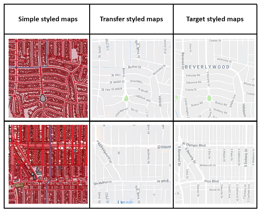
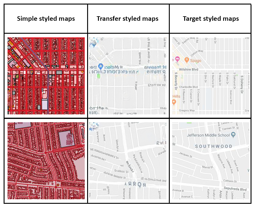
This paper proposes a methodology framework to measure human emotions at places with advanced artificial intelligence technologies and explore the relationship between human emotions and environmental factors. And a ranking list of tourist attractions around the world is created based on human happiness measured using over 2 million facial expressions.

Human happiness scores at world tourist attractions.

Related to this work, Yuhao Kang won the first place in the 2019 AAG Robert Raskin Student best paper competition. Link: http://gis.cas.sc.edu/cisg/?page_id=126

Here is the abstract:
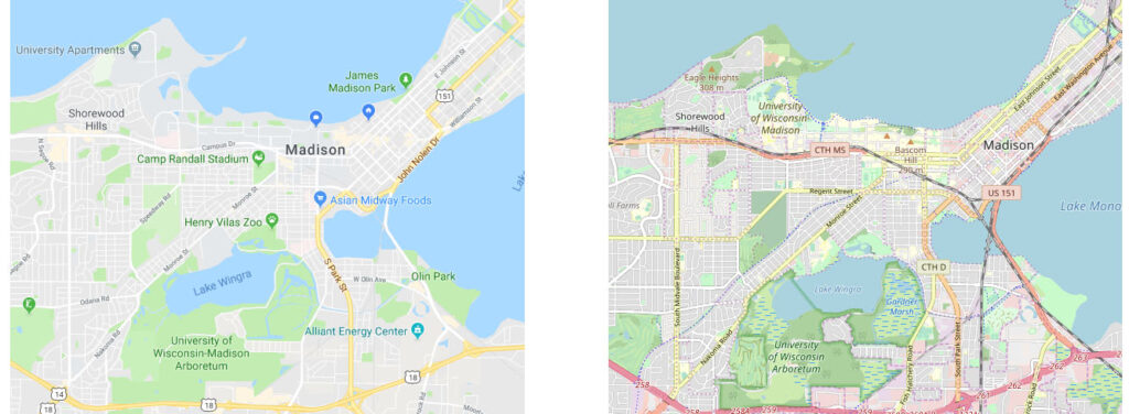
 The emergence of big data enables us to evaluate the various human emotions at places from a statistic perspective by applying affective computing. In this study, a novel framework for extracting human emotions from large-scale georeferenced photos at different places is proposed. After the construction of places based on spatial clustering of user generated footprints collected in social media websites, online cognitive services are utilized to extract human emotions from facial expressions using state-of-the-art computer vision techniques. And two happiness metrics are defined for measuring the human emotions at different places. To validate the feasibility of the framework, we take 80 tourist attractions around the world as an example and a happiness ranking list of places is generated based on human emotions calculated over 2 million faces detected out from over 6 million photos. Different kinds of geographical contexts are taken into consideration to find out the relationship between human emotions and environmental factors. Results show that much of the emotional variation at different places can be explained by a few factors such as openness. The research may offer insights on integrating human emotions to enrich the understanding of sense of place in geography and in place-based GIS.

Tourist attraction ranking based on the average happiness index using facial expressions.

Prof. Michael F. Goodchild visited UW-Madison

Recently, Prof. Mike Goodchild was invited to visit our lab and the Department of Geography at the University of Wisconsin-Madison. Prof. Goodchild is the Emeritus Professor of Geography at the University of California, Santa Barbara. He was elected member of the National Academy of Sciences and the American Academy of Arts and Sciences, etc. He gave a talk titled “Geography and GIScience: An Evolving Relationship” in the department Yi-Fu Tuan Lecture series on Friday, April 19th, shared his view of how GIScience and Geography evolved together during the past decades.

The GeoDS lab also invited Prof. Goodchild to join our research group meeting. Four lab members presented their recent works and received insightful suggestions and comments from Prof. Goodchild.

Timothy Prestby Received the HILLDALE FELLOW Award

Please join us congratulating our junior student Timothy Prestby, who is currently an undergraduate research assistant in the GeoDS Lab under Prof. Song Gao’s mentorship, just got the university “Hilldale Undergraduate/Faculty Research Fellowships” and was awarded  in the 2019 Chancellor’s Undergraduate Awards Ceremony! 

The awarded research project title is: Understanding Neighborhood Isolation through Big-Data Human Mobility Analytics”. 

Previous Hilldale Fellows at the University of Wisconsin-Madison:

https://awards.advising.wisc.edu/campus-wide-award-recipients/test-hilldale-fellows/

GeoDS Lab at the 2019 AAG Annual Meeting

During the last week (April 3-7), six GeoDS lab members have actively participated in the 2019 AAG Annual meeting and successfully presented their work. Especially congratulations to Yuhao Kang who won the first place in the Robert Raskin Student best paper competition!

Yuhao Kang presented his work titled “Human Emotions at Different Places: A Ranking of Happiest Tourist Attractions around the World Based on Facial Expressions and Spatial Clustering Analysis” in the Cyberinfrastructure Specialty Group Student paper competition Session. [Abstract]. Robert Raskin Student Competition 2019: http://gis.cas.sc.edu/cisg/?page_id=126

Yunlei Liang presented her work titled “Optimizing Bus Stop Spacing Using a Spatial Interaction Coverage Model and the Maximal Covering Location Problem Model” in the Spatial Analysis and Modeling Specialty Group Student paper competition Session. [Abstract]

Mingxiao Li presented his work titled “Reconstruction of human movement trajectories from large-scale low-frequency mobile phone data” in the GeoAI and Deep Learning Symposium. [Abstract]

Yuqi Gao presented her work named “Analyzing Regional Economic Indicators from Transportation Network Analytics” in the Automated GISci for Network-based Decisions Session. [Abstract]

Timothy Prestby presented his work titled “Linking Traffic Volume to Economic Development Index Using Big Data and Gravity Models” in the Urban Geography Poster Session. [Poster]

Professor Song Gao co-organized The 2nd AAG Symposium on GeoAI and Deep Learning for Geospatial Research and was invited to the panel discussions of “Urban Data Science”.

Congrats to all of them! Go Badgers!

Group Photo

Professor Gao was appointed as the Associated Editor of Annals of GIS

Professor Song Gao was invited and appointed as the Associated Editor for the CPGIS flagship journal: Annals of GIS  published by Taylor & Francis.

Annals of GIS is an international peer-reviewed journal that encourages the interdisciplinary exchange of original ideas on theory, methods, development and applications in the fields of geo-information science. Research papers are invited to cover the latest development in the following areas:

  • remote sensing and data acquisition
  • geographic information systems
  • geo-visualization and virtual geographic environments (VGE)
  • spatial analysis and modeling
  • uncertainty modeling

and their applications in natural resource, ecosystem, urban management, and other humanities and social science areas.

Funded Project: A Data-Synthesis-Driven Approach to Place-Based Social Sensing

PI: Prof. Dr. Song Gao

Funded by UW-Madison Office of the Vice Chancellor for Research and Graduate Education (VCRGE) and the Wisconsin Alumni Research Foundation (WARF).

Abstract:

Place names and the semantics of places described in natural languages rather than coordinates (i.e., longitude and latitude) are pervasive in human discourse, documents, and social media while location needs to be specified for mapping or interlinking other information. However, there is still a gap between the informal or vague cognition expressions of place (e.g., downtown, neighborhood, up north Wisconsin) and the formal computational representations of place in computerized information systems. Cognitive regions and places are notoriously difficult to represent in geographic information science and systems. They arise from the complex interactions of individuals, society, and the environment.

The emergence of big data brings new opportunities to better understand our geographic and socioeconomic environments. In this research, we will synthesize multi-source datasets from census, location-based social networks, news media, Wikipedia, travel blogs, and other open data websites, and utilizing the theory of place, natural language processing, machine learning, and visualization techniques for extracting and representing vague cognitive places. The research will also help better understand individuals’ observations, experiences, and exposures to different types of places and ambient social environments.

References:

Gao, S., Janowicz, K., Montello, D. R., Hu, Y., Yang, J. A., McKenzie, G., Ju, Y., Gong, L., Adams, B., & Yan, B. (2017). A data-synthesis-driven method for detecting and extracting vague cognitive regionsInternational Journal of Geographical Information Science31(6), 1245-1271.

Gao, S., Li, L., Li, W., Janowicz, K., & Zhang, Y. (2017). Constructing gazetteers from volunteered big geo-data based on Hadoop. Computers, Environment and Urban Systems61, 172-186.

Gao, S., Janowicz, K., & Couclelis, H. (2017). Extracting urban functional regions from points of interest and human activities on location‐based social networks. Transactions in GIS21(3), 446-467.

Gao, S., Janowicz, K., McKenzie, G., & Li, L. (2013, November). Towards Platial Joins and Buffers in Place-Based GIS. In Proceedings of The First ACM SIGSPATIAL International Workshop on Computational Models of Place (pp. 42-49).

Prestby, T., App, J., Kang, Y., & Gao, S. (2019). Understanding Neighborhood Isolation through Spatial Interaction Network Analysis using Location Big Data. Environment and Planning A: Economy and Space.

Papadakis, E., Gao, S., & Baryannis, G. (2019). Combining Design Patterns and Topic Modeling to Discover Regions Supporting Particular Functionality. ISPRS International Journal of Geo-Information. 8(9), 385.

Liu, Y., Yuan, Y., & Gao, S. (2019). Modeling the Vagueness of Areal Geographic Objects: A Categorization SystemISPRS International Journal of Geo-Information8(7), 306. DOI:https://doi.org/10.3390/ijgi8070306

Blaschke, T., Merschdorf, H., Cabrera-Barona, P., Gao, S., Papadakis, E., & Kovacs-Györi, A. (2018). Place versus Space: From Points, Lines and Polygons in GIS to Place-Based Representations Reflecting Language and Culture. ISPRS International Journal of Geo-Information7(11), 452.

Yan, B., Janowicz, K., Mai, G., & Gao, S. (2017, November). From ITDL to Place2Vec: Reasoning About Place Type Similarity and Relatedness by Learning Embeddings From Augmented Spatial Contexts. In Proceedings of the 25th ACM SIGSPATIAL International Conference on Advances in Geographic Information Systems (p. 35). ACM.

Hu, Y., Gao, S., Janowicz, K., Yu, B., Li, W., & Prasad, S. (2015). Extracting and understanding urban areas of interest using geotagged photos. Computers, Environment and Urban Systems, 54, 240-254.

Liu, Y., Liu, X., Gao, S., Gong, L., Kang, C., Zhi, Y., Chi, G., & Shi, L. (2015). Social sensing: A new approach to understanding our socioeconomic environments. Annals of the Association of American Geographers105(3), 512-530.

McKenzie, G., Janowicz, K., Gao, S., & Gong, L. (2015). How where is when? On the regional variability and resolution of geosocial temporal signatures for points of interest. Computers, Environment and Urban Systems54, 336-346.

McKenzie, G., Janowicz, K., Gao, S., Yang, J. A., & Hu, Y. (2015). POI pulse: A multi-granular, semantic signature–based information observatory for the interactive visualization of big geosocial dataCartographica: The International Journal for Geographic Information and Geovisualization50(2), 71-85.

Two Papers Accepted at ACM SIGSPATIAL 2018

Congratulations to Yuhao Kang and Yunlei Liang for their paper acceptance! Check “Publication” for more details.

“Utilizing Reverse Viewshed Analysis in Image Geo-Localization” by Yuhao Kang, Song Gao, and Yunlei Liang, has been accepted at the 2nd ACM SIGSPATIAL International Workshop on Recommendations for Location-based Services and Social Networks (LocalRec 2018).

Optimizing Bus Stop Spacing Using the Simulated Annealing Algorithm with Spatial Interaction Coverage Model“, by Yunlei Liang, Song Gao, Tianyu Wu, Sujing Wang and Yuhao Wu, has been accepted for presentation at the 11th ACM SIGSPATIAL International Workshop on Computational Transportation Science (IWCTS 2018).